Download
1 / 57
570 likes | 845 Views
Green Mountain National Forest Wilderness : An Enduring Resource. What We Will Do :. Lay out the locations and some of the highlights of the eight Green Mountain National Forest Wilderness areas.

E N D
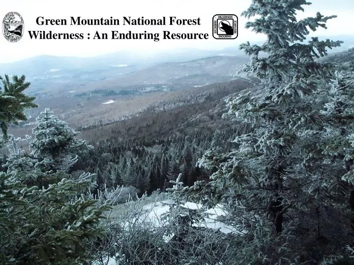
Green Mountain National Forest Wilderness : An Enduring Resource
What We Will Do : • Lay out the locations and some of the highlights of the eight Green Mountain National Forest Wilderness areas. • See how the Wilderness Acts including the latest New England Wilderness Act of 2006 added acres to the Green Mountain National Forest. • Discover the public purposes of wilderness. • Explore the role of Wilderness Rangers on the Greens and how they work to monitor and protect wilderness from threats to an enduring resource.
Why preserve wilderness? Pioneers had cleared the land in Vermont: 75% cleared to 25% forested. In the late 1800’s, people in America began to realize wilderness as a limited resource that needed protection. George Perkins Marsh
An Evolution of Conservation and Preservation Ideas Gifford Pinchot: The first Chief of the Forest Service in 1905.
The Multiple Use Management Area Concept in the US Forest Service
Doing the Math: • 400,000 plus acres exist on the Green Mountain National Forest. • 101,000 acres has been designated as Wilderness. • 25% of the Green Mountain National Forest is Wilderness.
Wilderness Legislation • Wilderness Act of 1964 • Established the National Wilderness Preservation System. • “Eastern Areas” Wilderness Act of 1975 • Created Lye Brook and Bristol Cliffs Wilderness. • PL 94-268 (1976) • Adjustment of Bristol Cliffs Wilderness boundary to accommodate private lands. • Vermont Wilderness Act of 1984 • Created George D. Aiken, Big Branch, Peru Peak, and Breadloaf. It made additions to Lye Brook.
Wilderness Legislation (cont.) • New England Wilderness Act signed by President Bush December 1 of 2006. • Established the Glastenbury and Joseph Battell Wilderness areas. It made additions to Lye Brook, Big Branch, Peru Peak, and Breadloaf Wilderness areas. • Established the Moosalamoo National Recreation Area.
The Glastenbury Wilderness has the Appalachian and Long Trail traverse its slopes for eight miles or so. • There are no shelters inside this wilderness but a lookout tower and shelter are nearby. • The Glastenbury/West Ridge Loop Trail offers a 21.8 mile hike through a good part of the Wilderness. • Snowmobile trail systems sometimes border this new wilderness. The New England Wilderness Act of 2006 adds Glastenbury as an entirely new wilderness at 22,425 acres.
The Joseph Battell Wilderness area traverses about 9.9 miles of the Long Tail. • Monastery Mountain is an untrailed peak at 3,224 feet. • The spur trail from the Mount Horrid Cliff is closed from March 15 to August 1 so that Peregrine Falcons can nest undisturbed. The New England Wilderness Act of 2006 adds Joseph Battell Wilderness as an entirely new wilderness at 12,333 acres.
New issues in the new Wilderness: Rock climbing, ice climbing, caving, bat protection and the disturbance of fragile plants in a Resource Natural Area on the MT Horrid Cliffs in the Joseph Battell Wilderness will likely need upper management recognition to sort how to best legally protect the resources.
The Breadloaf Wilderness is named after Bread Loaf Mountain at 3,835 feet. • Climb Vermont's Presidential Range: Mounts Wilson, Roosevelt, Cleveland, and Grant. • Moose and black bears live here in considerable numbers. • Contains 17.4 miles of the Long Trail, four shelters and five major side trails. The New England Wilderness Act of 2006 adds 3,757 acres.
The Big Branch Wilderness is named after Big Branch Stream. • Located just west of the Peru Peak Wilderness. • Separated by snowmobile Corridor 7. • Contains about 6 miles of the AT/LT. • Big Branch shelter is on AT/LT. The New England Wilderness Act of 2006 adds 47 acres.
The Peru Peak Wilderness is named after the highest mountain in the area. • Contains 4 miles of the Appalachian/ Long Trail. • Styles Peak has a view and Peru Peak is wooded. • Pete Parent Peak, a 3,000-footer that, unlike most in Vermont, has no marked path to the top. • There are no shelters or platforms in this Wilderness but there are some near Griffith Lake. The New England Wilderness Act of 2006 adds 752 acres.
Lye Brook Wilderness ranges from 900 feet to 2900 feet above sea level. • The western section is extremely steep, facing west-northwest towards U.S. Route 7 and Manchester. • The Appalachian/Long Trail skirts the northeast corner for about 3 miles. • South Bourn Pond shelter was removed in 2005. • Remnants of railroad grades and old logging roads remain. The New England Wilderness Act of 2006 adds 2,338 acres.
The George D. Aiken Wilderness was named after the late senator who helped secure the Eastern Wilderness Act of 1975. • Sits on a plateau rising as high as 2,300 feet. • Land of ponds, meadows, hills and brushy forest. • Popular for cross country skiing and snow shoeing in the winter. • Like Bristol Cliffs, is managed without designated trails.
The Bristol Cliffs Wilderness was named for unique cliffs on west side. • Like the Aiken, is managed without designated trails. • North Pond and Gilmore Ponds. • Home to bears, moose, grouse, peregrine falcons and the tallest hobblebush in the state!
The Moosalamoo National Recreation Area (NRA) was established under the New England Wilderness Act of 2006. • A main objective is to showcase National Forest multiple use management. • The Joseph Battell Wilderness is outside this NRA. The New England Wilderness Act of 2006 created an entirely new NRA at 15,800 acres.
Some Initial Administrative Steps Involving the Implementation of the New England Wilderness Act of 2006 • Establish a communication link between five property owners who have inholdings. • Identify roads for closure that maybe obliterated after an appropriate environmental analysis is complete. • Request funding for 30 miles of boundary to be completed by surveyors to Forest Service standard. • Continue to fund Wilderness Rangers and a wilderness work force dedicated to completion of national goals .
Some Initial Field Steps Involving the Implementation of the New England Wilderness Act of 2006 • Move nine, existing wilderness boundary portal signs and associated new wilderness maps and information. • Paint, carry and install eight, new wilderness boundary portal signs, wilderness maps and information. • Inventory all new boundaries and remote sections for nonconforming uses. • Post wilderness boundary license plates at locations where motorized and mechanized use is occurring or could occur with a GPS device. • Travelways Management: Move rocks and debris onto illegal trails that lead into wilderness to keep motorized and mechanized equipment out. • Hire a hand crew to remove some road culverts in the new wilderness.
The 1964 Wilderness Act – Sec. 4(b) … wilderness areas shall be devoted to the public purposes of recreational, scenic, scientific, educational, conservation, and historical use.
…”devoted to the public purposes of recreational, scenic, scientific, educational, conservation, and historical use”
…”devoted to the public purposes of recreational,scenic, scientific, educational, conservation, and historical use”
…”devoted to the public purposes of recreational, scenic, scientific, educational, conservation, and historical use”
…”devoted to the public purposes of recreational, scenic, scientific, educational, conservation, and historical use” Leave No Trace Puppet Show and Hands-on Activity Station
…”devoted to the public purposes of recreational, scenic, scientific, educational, conservation, and historical use”
…”devoted to the public purposes of recreational, scenic, scientific, educational, conservation, and historical use”
Why Monitor Threats to Wilderness? A loss of naturalness and wildness is incremental. Ultimately, in the long run, if monitoring is not consciously done, “degradation creep” builds up to dramatic levels and it is often difficult to reverse. Joseph Battell Wilderness: An old, abandoned human shelter remaining as trash and an unidentifiable, research study plot marker (one of many here).
Some Wilderness Ranger Activities to Protect Wilderness as an Enduring Resource • Abandoned Property , Human-made Structures and Trash Removal. • Campsite Condition Inventory and Monitoring. • Wilderness Boundary Monitoring and Signing. • Monitoring Motorized and Mechanical Equipment Trespass. • Advanced Technology : Following Geocaching. • Monitoring Pre-existing Special Use Authorizations, Recreation and Non-recreation Special Use Permits. • Finding and Documenting Illegal Trail Cutting. • Invasive Species Inventory and Removal. • Reports, Records and Data Entry.
Human-made Structure Removal: From Native Materials to Processed Wood Construction
Campsite Condition Inventory and Monitoring • Digital Pictures • GPS Locations • Site Mapping, Measuring and Reference Points • Inventory of Area Damages
Monitoring Motorized and Mechanical Equipment Trespass: Motorcycles and ATV’S
Monitoring Motorized and Mechanical Equipment Trespass: Snowmobiles
Monitoring Pre-existing Special Use Authorizations Non- Recreation Special Use Permits Recreation Special Use Permits
< A sign has been placed stating no cutting or maintaining of new trails is allowed without permission on an illegally cut trail. Repeated glade skiing by groups does undocumented damage on vegetation too. > Photo by Jeff Harvey 1/27/2008
The Chief’s Ten Year Wilderness Stewardship Challenge Goal : To have all the Forest Service wilderness areas managed to a “minimum stewardship level” by 2014 coinciding with the 50th anniversary of Wilderness Act.
Invasive Species Identification and Removal Bush Honey Suckle Japanese Barberry Garlic Mustard Japanese Knotweed