Download

1 / 26
260 likes | 405 Views
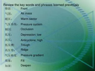
Review the key words and phrases learned previously. 锋面 : 气团: 暖区: 气压系统: 锢囚 : 低压: 高压: 低压槽 : 高压脊: 气压梯度 : 填塞: 加深 :. Front. Air mass. Warm sector. Pressure system. Occlusion. Depression; low. Anticyclone; high. Trough. Ridge. Pressure gradient. Fill. Deepen.

E N D
Review the key words and phrases learned previously 锋面 : 气团: 暖区: 气压系统: 锢囚: 低压: 高压: 低压槽: 高压脊: 气压梯度: 填塞: 加深: Front Air mass Warm sector Pressure system Occlusion Depression; low Anticyclone; high Trough Ridge Pressure gradient Fill Deepen
Try to answer the following questions 1. What is the difference between backing and veering? Backing means a change in the direction of wind in an anti-clockwise direction, while veering, clockwise direction. 2. Under what condition will occlusion happen? The cold front moves faster than the warm front and gradually overtakes it, causing the warm to be lifted up from the surface. When this happens the depression is said to be occluded, known as occlusion. 3. What type of weather will a steep pressure gradient and a weak gradient respectively indicate? Weather in strong or steep pressure gradients is normally subject to sudden changes with varying wind force and direction while weak gradient indicates that the weather changes are gradual and predictable. 4. What type of barometer is most commonly used aboard ship? Aneroid barometer.
Radio Weather Messages Warnings Synopses Forecasts direction and speed of wind, the weather, temperature, visibility and state of the sky and sea over a period 12 or 24 hours Gale Warnings 8-9 Storm Warnings 10-11 General Situation, Synoptic Situation, Synopsis, Summary Hurricane Warnings 12 or above pressure systems and fronts, their direction, speed of movement pressure systems and fronts, their direction, speed of movement Low, high, front
Gale Warning • 大风警报: • 暴风警报: • 飓风警报: • 紧急的: • 大势: • 阴: • 晴: • 零星阵雨: • 局部阵雨: • 雷暴雨: • 轻浪/中浪/大浪: • 能见度不良/中等/良好: Storm Warning Hurricane Warning Imminent Synopsis, General situation, Synoptic situation, Summary Overcast Clear, fine, fair Scattered shower Isolated shower thunderstorm slight, moderate, rough poor, moderate, good
Vocabulary study imminent [5iminEnt] adj. 紧急的(自原发报时间起4小时之内) soon [`su:n] adj.不久(约4小时以后和12小时以前) later [5leitE] adj.以后(约12小时以后) synopsis [si5nCpsis] n. (pl. synopses)大势 barometric [7bArEu5metrik] adj.大气的,气压的 tendency [5tendEnsi] n.趋势 summary [5sQmEri] n. 大势,总结,摘要 issue [5isju:] vt. 发布 issuance [5iFu(:)Ens] n. persist [pE(:)5sist] vi.持续 swell [swel] n. 涌 patch [pAtF] n.片,小块地 rain patches 小片地区有雨 on behalf of 代表 coastguard n.海岸警卫队 UTC= universal coordinated time 协调世界时 valid [5vAlid] adj. 有效的 tend [tend] vi.趋向 outlook [5autluk] n. 气象预报(当天24小时以后的预报) persist in the study of English 坚持学习英语 On the top of very high montains snow persists thronghout the year. 高山顶上, 积雪终年不化。
e – east 东 w – west 西 s – south 南 n – north 北 ely – easterly 偏东 sly – southerly 偏南 wly – westerly 偏西 nly – northerly 偏北 ne – northeast 东北 nw – northwest 西北 se – southeast 东南 sw – southwest 西南 ene – east-north-east 东北东 wsw – west-south-west 西南西 nm – nautical mile 海里 km – kilometer 公里 ml – mile 海里 mb – millibar 毫巴 kt – knot 节 vis – visibility 能见度 temp – temperature 温度 C – degrees Celsius 摄氏度 vrb – variable 风向不定 slw – slow 缓慢的 frq – frequent 经常的 stnr – stationary 静止的 qstnr– quasi-stationary 准静止
tempo – temporary 临时的 press – pressure 压力 baro – barometer 气压表 deg – degree 度 ft – foot/feet 英尺 mod – moderate 适中 max – maximum 最大 min – minimum 最小 sit – situation 形式 wx – weather 天气 gmt–Greenwich Mean Time 世界时 z – zulu time 世界时 wrng – warnings 警告 msg – message 电文 obsy – observatory 气象台 pd – period 句点 para – paragraph 段 cma – comma 逗号 pt – point 点 wkn – weaken 减弱 lgt – light 轻 isol – isolated 局部的 sct – scattered 零星的 ocnl – occasional 偶尔 cld – cloudy 多云 dz – drizzle 毛毛雨 ts – thunderstorm 雷阵雨 nc – no change 趋势少变
Beaufort wind scale ripple [5ripl] n.涟漪,波纹,微波 wavelet [5weivlit] n.微波,子波,小波 crest [krest] n.波峰 whitecap [5(h)waitkAp] n.(海面)翻白花,白浪花 white horse 白涌头,白浪花 spray [sprei] n. 水花,浪花 foam [fEum] n.泡沫, 水沫 airborne [5ZEbC:n] adj.空中的,空气传播的
Beaufort wind scale streak [stri:k] n.条痕,小沟 spindrift [5spindrift] n.海浪的飞沫,浪花 overhang [5EuvE5hAN] vi.悬于……之上, 悬垂 tumbling [5tQmbliN] n.翻跟头,翻筋斗
Wave scale furrow [5fQrEu] vt. 犁,耕,弄绉 precipitous [pri5sipitEs] adj.陡峭的,急躁的
Visibility scale 注意公里和海里的换算。1 mile ≈ 1.852 km
Part Two Marine Weather Introduction 关于,至于 [hju:5miditi] n. 湿气,湿度 Weather is the state of the earth's atmosphere with respect to temperature, humidity, precipitation, visibility, cloudiness, and other factors. All weather may be traced to the effect of the sun on the earth. Most changes in weather involve large-scale horizontalmotion of air. Weather is of vital importance to the mariners. The wind and state of the sea affect dead reckoning and reduced visibility limits piloting. The state of the atmosphere affects electronic navigation and radio communication. If the skies are overcast, celestial observations are not available; and under certain conditions refraction and dip are disturbed. When wind is the primary motive power, knowledge of the areas of favorable winds is of great importance. Modern vessels are still affected considerably by wind and sea. 航迹推算,船位积算 The process of calculating one‘s position, esp. at sea, by estimating the direction and distance traveled rather than by using landmarks, astronomical observations, or electronic navigationmethods 利用航向和航速,并计算风流因素得到的船位。 [treis] vt. 回溯,探索 水平 运动 celestial[si5lestjEl, si5lestFEl] adj. 天文的,天体的 [ri5frAkFEn] n. 折光,折射 [dip] n. 眼高差 水平线和视平线夹角 [kEn5sIdErEbElI] adv. 相当地
Passage One Tropical Cyclones Vocabulary study • equator [i5kweitE] n. 赤道 • baffle [5bAfl] vt. 困惑, 阻碍 baffling wind 不定向风 • doldrums [5dCldrEmz] n. 赤道无风带 • willy-willy [5wili5wili] n.畏来风,(澳大利亚的)强热带气旋 • baguio [bB:^i:5Eu] n.碧瑶风(菲律宾的强烈热带气旋) • circular [5sE:kjulE] adj.圆形的,环形的 • elliptical [i5liptikEl] adj. 椭圆的 • whirling [(h)wE:liN] adj. 旋转的 • eddy [5edi] n.旋转, 漩涡 • calm [kB:m] n.静风 • horse latitudes 副热带无风带 • precede [pri(:)5si:d] vt.在……之前, 先于 • cirrus [5sirEs] n.卷云 • bearing [5bZEriN] n.方位
reliably [ri5laiEbli] adv. 可靠地 distinct [dis5tiNkt] adj.明显的, 截然不同的 diurnal [dai5E:nl] adj. 全日的,每日的, 白天的 signify [5si^nifai] vt. 表示, 意味 cirrostratus [5sirEu5strB:tEs] n.卷层云 bank [bANk] n. (云)层 horizon [hE5raizn] n.地平线 gusty [5^Qsti] adj.阵风的 portion [5pC:FEn] n.一部分 semicircle [5semi5sE:kl] n. 半圆 dangerous semicircle 危险半圆 navigable [5nAvi^Ebl] adj. 适于航行的,可航的 navigable semicircle 可航半圆 add to 增加 subtract [sEb5trAkt] vt. (~ from) 减去, 减 peak [pi:k] vt. 到达最高点 n. 山顶,最高峰 statistical [stE5tistikEl] adj. 统计的,统计学的 encompass [in5kQmpEs] vt.包围,环绕,包含
Tropical Cyclones Near the equator lies a low-pressure belt where winds are either light and variable or nonexistent. There are frequent thunderstorms and squalls.This belt of baffling winds and rain is called the doldrums and is the breeding place of the most violent of all storms— tropical cyclones. In the Atlantic, tropical cyclones are known as hurricanes; in the Pacific, as typhoons; in Australia, as willy-willies; and in the Philippines, as baguios. All are alike in character. The use of the term "hurricane" will apply to all of these systems. Hurricanes are circular or elliptical whirling eddies of air up to 400 miles in diameter. Wind speeds reach as high as 150 or more knots near the center, but decrease toward the edges. In the Northern Hemisphere, the wind blows in a counterclockwise direction; in the Southern Hemisphere, it blows in a clockwise direction. Typical of these storms is a calm at the center or eye, which may be 5 to 40 miles in diameter. When the eye of a storm passes over an area, wind that has been violent decreases to a much lower speed and at times becomes calm and precipitation stops. When the eye has passed, the winds come from the opposite direction. 赤道附近的低压带中刮风向不定的清风,或者无风,常有雷暴雨和狂风。这个风向不定的低压带被称为赤道无风带,是最猛烈的一种暴风 — 热带气旋的孳生地。 这种暴风的典型特征是在直径为5到40海里的暴风中心或风眼处平静无风,当暴风风眼到达一个地区上空时,原本猛烈的风明显减速,有时还会风平浪静,降水停止。当暴风风眼经过后,风从相反方向吹来。
The actual cause of the formation of hurricanes is unknown. Soon after they form, they begin to move at speeds from 5 to 20 miles per hour. In the Northern Hemisphere, they generally follow a slightly curving path to the north and west until reaching the horse latitudes. The hurricanes then re-curve to the northeast, pick up speed over the surface, become less violent, and finally blow themselves out. In the Southern Hemisphere, the general path of hurricanes is first to the southwest and then they re-curve to the southeast. The life of a hurricane is about 10 days. Hurricanes are usually preceded by a day of good visibility. Temperature and pressure are slightly higher than normal. Cirrus clouds appear. Wind changes direction and increases in force; sea swells increase their period. At night, the temperature is generally lower than normal. During the summer and fall in the Gulf of Mexico and the Caribbean Sea, the bearing of the storm is reliably indicated by the direction from which the swells come. In any other area this sign is unreliable. . 在北半球,热带气旋通常沿着稍弯的路径向北向西前进直到抵达副热带无风带,然后重新折回东北,加速、减弱并最终消散。
A vessel in the navigable semicircle would probably be blown to a position behind the storm. It is also clear that speed of the wind in the right semicircle would be greater as the speed of the storm over the surface would be added to the speed of the wind. In the left semicircle, speed of the storm would be subtracted from speed of the wind; therefore, wind and sea would be less violent. In the Northern Atlantic Ocean, a distinct hurricane season occurs from June 1 to November 30, sharply peaking from late August through September. The statistical peak of the Atlantic hurricane season is 10 September. The Northeast Pacific Ocean has a broader period of activity, but in a similar time frame to the Atlantic. The Northwest Pacific sees tropical cyclones year-round, with a minimum in February and March and a peak in early September. In the North Indian basin, storms are most common from April to December, with peaks in May and November. In the Southern Hemisphere, the tropical cyclone year begins on July 1 and runs all year round and encompasses the tropical cyclone seasons which run from November 1 until the end of April with peaks in mid-February to early March.
Passage Two Prevailing Winds and Fogs Vocabulary study prevailing [pri5veiliN] adj. 主要的, 流行的,盛行的 prevailing westerlies 盛行西风带 expand [iks5pAnd] vi.膨胀,扩张 contract [5kCntrAkt] vt.缩短,收缩 equatorial [7ekwE5tC:riEl, i:k-] adj.近赤道的, 赤道的 polar [5pEulE] adj.两极的, 极地的 poleward [5pEJlwEd] adj.向南(或北)极的,向极的 excess [ik5ses, 5ekses] n. 过度,过剩 definite [5definit] adj. 明确的, 一定的 extend [iks5tend] vi.延伸,伸展 in the vicinity of 在……附近 shift [Fift] vi. 转换,移动 characterize [5kArIktEraIz] vt. 表现……的特色 trade wind 信风 permanent [5pE:mEnEnt] adj.永久的, 持久的
duration [djuE5reiFEn] n.持续时间, 为期 due [dju:] adj. 正向着的 due west 正西 land mass 大陆块 land breeze 向海风,陆风 sea breeze 向陆风,海风(从海上吹来的和风) alternating [C:l5tE:nitiN] adj. 交互的 adjoining [E5dVCiniN] adj.邻接的 penetrate [5penitreit] vi.穿透,渗透,弥漫 onshore [5Cn5FC:] adv. 向着海岸,在陆上 offshore [5C(:)fFC:] adv.向海面吹地,离岸地,近海地 monsoon [mCn5su:n] n.季风 torrential [tC5renFEl] adj.猛烈的,奔流的 suspend [sEs5pend] vi. 悬浮 radiation fog 辐射雾 advection fog 海面雾,平流雾 steam fog 蒸汽雾 evaporation [i7vApE5reiFEn] n.蒸发(作用) saturate [5sAtFEreit] vt., vi.(使)饱和 frontal fog 锋面雾
Prevailing Winds Doldrums: The low pressure belt extending around the earth in the vicinity of the geographical equator. They shift slightly north or south with the seasons. They are characterized by light winds, cloudiness, afternoon thunderstorms and showers, and a depressing humidity. 赤道无风带是在地理赤道附近围绕地球延伸的低压带,随着季节的变化会稍微向北或向南移动。其特征为轻风、多云、午后雷暴雨和阵雨、湿度高、闷热。 Trade winds: The relatively permanent winds on each side of the equatorial doldrums that blow from the northeast in the Northern Hemisphere and from the southeast in the Southern Hemisphere. 副热带无风带是南北半球分别位于信风带向极地方向的高压区,静风和不定向风盛行。与赤道无风带不同,在赤道无风带,空气清新,天气晴朗,静风持续时间不长。 Horse latitudes: These are zones of high atmospheric pressure on the poleward side of each trade wind where calms and variable winds prevail. The conditions are unlike those in the doldrums where the air is fresh and clear and calms are not of long duration.
Prevailing westerlies: The prevailing westerly winds (winds blowing from the west) are those on the poleward sides of the horse latitudes. Land and sea breeze: The cause of land and sea breezes is the alternating heating and cooling of coastal land and sea areas. The land, particularly in summer, is warmer than the sea by day and cooler than the sea by night. Therefore, there is a variation in atmospheric pressure over adjoining land and sea areas. This causes a system of littoral breezes which blow landward during the day and seaward during the night. These land and sea breezes usually penetrate to a distance of about 30 miles onshore and offshore, and extend to a height of a few hundred feet.
Fog Radiation fog: Radiation fog occurs at night. It only forms when the land cools; which in turn, cools the air above. Advection fog: Advection fog is the most widespread type likely to be encountered at sea and occurs when warm air flows over a cool surface. Advection fog can form only in regions where marked temperature contrasts exist within a short distance of each other and only when the wind blows from the warm area toward the cold area.
Steam fog: Steam fog is a type of advection fog. It occurs when cool air blows over a warm surface. Evaporation from the warm surface easily saturates the cool air, causing fog, which rises from the surface like smoke. Frontal fog: Frontal fog occurs in the cold air mass of a front. As warm rain falls into the cold air, it evaporates, saturating the cool air and causing the fog. Although the cool air already is saturated, evaporation from the rain continues as long as the temperature of the raindrops is higher than the temperature of the air. Frontal fogs are rarely caused by cold fronts because they usually move so rapidly and have such narrow bands of precipitation. Warm fronts, on the other hand, cause deep and long-lasting fogs that are considered the worst type to encounter.
Review the passages learned today and memorize the key words and expressions. Preview passage three and part three and pay attention to the following points: How many types of clouds are there in those three different cloud families and what are they? What type of weather does each cloud indicate? Familiarize yourself with the basic knowledge of weather routing. Homework