Download
1 / 32
320 likes | 451 Views
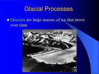
Glacial Cycles. There’s evidence that high latitudes have been ice-covered periodically throughout geologic history. When did these ice periods occur?. Why did these ice periods occur?. How much land was ice covered?. Pleistocene Continental Glaciation.

E N D
There’s evidence that high latitudes have been ice-covered periodically throughout geologic history. When did these ice periods occur? Why did these ice periods occur? How much land was ice covered?
Pleistocene Continental Glaciation • Recall: Pleistocene Epoch 1.8 to 0.15 Ma (Holocene Epoch since 0.15 Ma) • Great ice sheets extended into temperate regions multiple times: • Wisconsin0.20 – 0.018 Ma 0.20 m.y. interglacial • Illinoian0.55 – 0.40 Ma 0.40 m.y. interglacial • Kansan1.40 – 0.95 Ma 0.35 m.y. interglacial • Nebraskan2.00 – 1.75 Ma
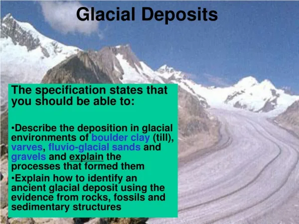
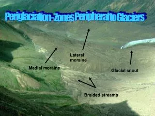
How do we know where glaciers were? • Ancient glacial deposits (till, dropstones). • Moraines in prairie country. • Glacial geomorphology (kettle lakes, striations, grooves). • Glaciations had to occur relatively recently because drift is soft (freshly deposited sediment). • Glacial deposits dated with carbon-14.
August 18,000 B.P. Fig. 16.26
Advance and retreat of continental glaciers • World-wide • Nearly instantaneous
Sea level changes • Also world-wide. • During glacial periods:More ice, lower sea level. • Lots of water in glaciers. During last ice age sea level lowered by ~130 m. • Shoreline 100 km from NYC. • If all ice in glaciers today would melt, sea level would rise 65 m: Florida, Egypt, Hong Kong, London, Houston.
So what causes ice ages? • Variations in Earth's orbit • Changes in the atmosphere • Changing position of the continents • Changes in circulation of sea water
Variations in Earth’s Orbit • Affects the amount of heat that the Earth receives from the sun. • Three components: • Eccentricity • Tilt • Precession
Eccentricity • The shape of Earth’s orbit around the Sun. • Varies from more circular to more elliptical. • Eccentricity: Circular = low, elliptical = high. • Period of time from low to high eccentricity = 100,000 years. Fig. 16.27
Tilt • How much the Earth’s rotational axis is tilted. • Varies from 21.5° to 23.5°. • Period = 41,000 years. Fig. 16.27
Precession • Earth wobbles on its axis of rotation (like a top). • Period = 23,000 years. Fig. 16.27
Milankovitch Cycles • Milankovitch: Yugoslavian geophysicist. • 1920s/1930s. • Glacial and interglacial cycles correspond to variations in Earth’s orbit. • Longer-term glaciations every 100,000 years; shorter-term glaciations every 20,000 and 40,000 years.
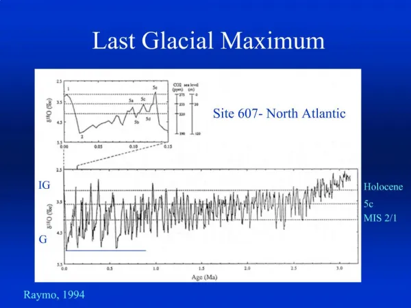
Orbit and ice ages How can we determine there were previous ice ages? • Continental sediment record: recognition and dating of glacial sediment on land • Oceanic sediment record: rock released by icebergs • Ocean surface temperature recorded by fossils • Ice volume changes recorded in the oxygen isotope record of fossils.
Oxygen isotopes • Involves two oxygen isotopes: 16O and 18O • Lighter isotope (16O) better able to go into the vapor phase. • Atmospheric water 16O/18O > ocean 16O/18O. • Precipitation out of the atmosphere will thus have higher 16O/18O (lighter) than the ocean. • Ice caps store lighter water. • Increase in ice caps makes water in the ocean heavier because of snow and ice build up in ice caps. • Marine organisms record the oxygen isotope composition of the seawater.
Oxygen Isotopes During ice age, More water in ice Water in oceans heavier in 18O (greater 18O/16O ratio)
Forams Foraminifera (forams): Small, single-celled marine organisms. Secrete shells of CaCO3. Shells record 16O/18O ratio of seawater where they live. Forams die, reign down on seafloor, forming sediment layer that can be cored.
Drilling into the ocean floor • Ocean Drilling Program (ODP). • International partnership of universities and research institutions. • Drill ship is Joides Resolution. 6 cruises per year, each 2 months in length and with 30 shipboard scientists. • Climate history, creation of oceanic crust.
ODP drill ship -- JOIDES Resolution • 469 feet long, 69 feet wide • Drilling derrick 200 feet tall • During drilling, ship is kept stationary by 12 computer-controlled thrusters • Rig can suspend over 9 km of drill pipe • Operates 24 hours per day. Lowering drill bit takes 12 hours in 5.5 km of water • Deepest hole penetrated 2.1 km (Hole 504B in East Pacific) • So far, drilled a total of 1555 holes
Oxygen Isotope Record of Forams Fig. 16.25 Glacial: less 16O in the ocean
Vostok Ice Core • Vostok is in Antarctic. • Russians have been drilling ice since 1960s.
Vostok Ice Core • Have now drilled to ~2.8 km (160,000 years). A couple of glacial periods. • Ice layers like tree rings. Can count number of years by counting ice layers. • Can also measure ratio of 16O to 18O in ice. • Can also measure CO2 and methane.
Vostok Ice Core 1. There is a decline in temperature and greenhouse gases during the onset of glacial periods 2. Rapid rise during deglaciation 3. Climate has been relatively warm during the last 10,000 years- the Holocene interglacial
GRIP and GISP2 Ice Cores • Greenland. • GRIP: Greenland Ice Core Project. Early 1990s. European scientists. 235,000 years. • GISP2: U.S. Greenland Ice Sheet Project 2. • GRIP and GISP2 correlate well with Vostok.
Glaciations aren’t gradual • Fast warming about 14,500 years ago. • Cooling 1,000 years later. • 12,500 years ago another period of glaciation started. Younger Dryas Event. Lasted about 1,000 years. • Temperature increased 11,700 years ago by about 6°C. Proceeded toward current interglacial period.
Glaciations aren’t gradual • These events happened quickly! • How quickly? As fast as 10 years. • Changes aren’t gradual. Like flipping a switch.
Ocean circulation • At end of glacial period, glacial melting and iceberg calving increases freshwater input to ocean. • For example, North Atlantic Ocean more fresh than usual. • This disrupts global ocean circulation patterns.
Ocean circulation: Interglacial • Warm surface water delivered to N. Atl. • Water cools, becomes more saline, sinks. • Cold, saline deep current flows south. • Thermohaline circulation (temperature and salt-driven). Fig. 16.28
Ocean circulation: Glacial • More fresh water enters oceans at high latitudes (from glacier melting, iceberg calving) • Thermohaline circulation disrupted, may even stop. • Correlated with cooling events in northern Europe and elsewhere.