Download
1 / 12
120 likes | 248 Views
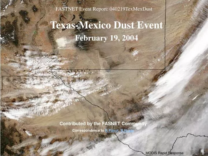
FASTNET Event Report: 040219TexMexDust. Texas-Mexico Dust Event February 19, 2004. Contributed by the FASNET Community Correspondence to R Poirot , R Husar. MODIS Rapid Response. The MODIS sensor on AQUA and Terra provides 250m resolution image s of the dust storm

E N D
FASTNET Event Report: 040219TexMexDust Texas-Mexico Dust Event February 19, 2004 Contributed by the FASNET Community Correspondence to R Poirot, R Husar MODIS Rapid Response
The MODIS sensor on AQUA and Terra provides 250m resolution images of the dust storm Visual inspection reveals the dust sources at the beginning of dust streaks. Satellites detect dust most storms in near real time The NOAA AVHRR sensor highlights the dust by its IR sensors In the TOMS satellite image, the dust signal is conspicuously absent – too close to the ground
Media and Other Accounts SOUTHLAND, Texas (AP) -- Thick, reddish-brown dust swirled over parts of West Texas, contributing to a series of traffic accidents that killed two people and injured dozens of others. As many as 30 vehicles crashed Thursday (2/19) on U.S. Highway 84 between Southland and Post, about 20 miles southeast of Lubbock, said Cpl. John Gonzalez with the Department of Public Safety. KBIM television reporter Abby Roedel films a vehicle accident during a dust storm Thursday (2/19/04) in New Mexico.
PM2.5 from EPA AIRNOW & RH-adjusted bscat: 2/18-20/04 Note Separate areas of high PM concentration and haze in both Northeast and Southwest Border Regions on 2/19/04.
Surface met data from the 1200 station network documents the strong winds that cause the windblown dust and resulting low-visibility regions
High Wind Speed – Dust Spatially Correspond The spatial/temporal correspondence suggests that most visibility loss is due to locally suspended dust, rather than transported dust Alternatively, suspended dust and ‘high winds’ travel forward at the same speed Wind speed animation; Bext animation. (material for model validation?)
The passage of the dust cloud from west to east is recorded by the high-resolution ASOS_STI Dry Bext data
PM10 > 10 x PM25During the passage of the dust cloud over El Paso, the PM10 concentration was more than 10 times higher than the PM2.5 AIRNOW PM10 and Pm25 data Schematic Link to dust modelers for faster collective learning?
The Mother of dust models, NAAPS, simulates the event well Green, dust surface concentration and optical thickness
Monte Carlo simulation of dust transport using surface winds (just a toy, 3D winds are essential!) See animation Note, how sensitive the transport direction is to the source location (according to this toy)
Did the dust travel to the Northeast and Quebec? Bob Vet reports high concentrations of dust in deposition samples from Chicago & southern Ontario with suspected origin from Tex/Mex dust storm. Michel Bisson reports “beige/orange snow” on Mt. Tremblent, Quebec and VT has multiple reports of “brown” or “reddish-brown” snow on 2/21/04.
WRF Research Model – No Dust SourceDo any of the HiRes models have dust sources a la NAAPS?