Download

1 / 18
180 likes | 188 Views
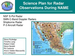
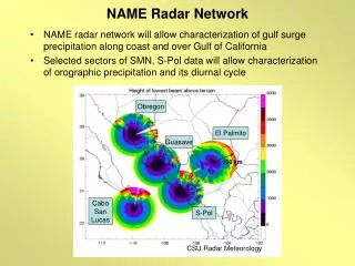
NAME Radar Network. NAME radar network will allow characterization of gulf surge precipitation along coast and over Gulf of California Selected sectors of SMN, S-Pol data will allow characterization of orographic precipitation and its diurnal cycle. Obregon. El Palmito. Guasave. 150 km.

E N D
NAME Radar Network • NAME radar network will allow characterization of gulf surge precipitation along coast and over Gulf of California • Selected sectors of SMN, S-Pol data will allow characterization of orographic precipitation and its diurnal cycle Obregon El Palmito Guasave 150 km Cabo San Lucas S-Pol CSU Radar Meteorology
Science Objectives of Radar Observations • Horizontal distribution of rainfall amount and intensity • Storm morphology • Diurnal cycle of rainfall and convection • Identify 2-D airflow features such as gust fronts, sea breezes, etc. • Hydrometeor identification to aid verification of models • Questions to be addressed by Radar Network • What are the (thermo)dynamical and microphysical characteristics of convection? • What is the diurnal behavior of convection within the monsoon regime? • What are the physical processes controlling the diurnal cycle over land and ocean? • How well do models simulate convection in complex terrain? • What is the connection between synoptic variability and Gulf surges? • What are the characteristics of Gulf surges? • What are the links between monsoon strength and precipitation over the central US?
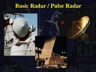
Platform Descriptions • NCAR/NSF S-Pol Radar • S-Band, Dual-Linearly Polarized, Doppler • Provides superior rain estimates to conventional radars • Can distinguish between hydrometeor types • SMN C-Band Doppler Radars • Four locations extend coverage region over much of Tier I • Run automatically, data saved via digitization upgrades • S-Pol radar, gauges can be used to help improve rain estimates
NSF/NCAR S-pol radar Used in TRMM/LBA, MAP and other projects. • NCAR S-POL (portable) • Polarimetric, Doppler • S-band, 10.7 cm • Zh, Vr, Zdr, Kdp,LDR
Measurement Protocols • S-Pol • 24-hour/day ops for 6 weeks starting 1 July • 15-minute cycle w/ 360 deg vol, PPI, and RHI sectors • Staffed by NCAR and CSU • SMN Radars • 24-hour/15-minute cycle matched w/ S-Pol • Pre-programmed 360-deg volumes w/ 7.5-min period • Oversight by Arturo Valdez-Manzanilla & NCAR
Data Dissemination Data will be disseminated in a delayed fashion due to high QC requirements of radar data – Need to remove blockage, clutter, and attenuation Raw data can be provided in standard formats quickly Combine QC’d S-Pol and SMN radar data into a merged regional product Gridded 2-D rain maps Gridded 3-D reflectivity/velocity fields Combined radar-raingage precipitation maps
Other Radar Products Gridded S-Pol hydrometeor identification, for model verification Available for most radar volumes In addition, S-Pol will be used to help correct attenuation and to improve Z-R estimates from SMN radars, through the polarimetric analysis of rain DSDs (“pol-tuning”) Gauge data will be used to assist this process Anticipate quick delivery of raw data (DORADE, UF) for individual radars, but creation of regional composites could take several months for full dataset Can fasttrack high-priority cases!
REAL-TIME AVAILABILITY • Will have TITAN system at one SMN radar – probably Cabo due to potential wireless connection (LOS to city) • Other radars will not have real-time availability – save data to removable hard drives that will be swapped out ~weekly during regular site visits • Data will be brought to S-Pol for storage • S-Pol will have satellite Internet – can post real-time data
Field Coordination Requirements • S-Pol will be base of radar observations – can provide guidance for P-3 ops if desirable; VHF radio needed • SMN radars cannot be adjusted for individual events; scan strategy will be set prior to project • Limited to 1-deg steps starting at 0-deg elevation • Dependent on spin rate of radars • Will do 7.5-min volumes if 20 deg/s • 10-min volumes if slower • S-Pol will adjust PPI and RHI sectors depending on evolving situation; However, there will be 360 deg volumes available every 15-min for rain maps, etc.
NCAR S-Pol Site • Steep coastal topography in the area 25-50 km north of Mazatlán limited the survey to the area near La Cruz, Sinaloa • Site was selected ~5 km west of La Cruz, 3 km from the GofC, 3 km from federal toll highway 15D CSU Radar Meteorology
S-Pol Beam Blockage Simulations • A simple model of beam propagation and a digital elevation model estimates good low level S-Pol coverage over the ocean, coastal plain, with mountain blockage in the NE quadrant DEM terrain 0.5° blockage 0.9° blockage CSU Radar Meteorology
NAME Observing System CSU Radar Meteorology
CURRENT STATUS • S-Pol nearly ready to be shipped. Ka-band component may be available starting sometime during project – low rain rates • Provided blockage maps to rain gauge scientists for placement of final gauges • SMN radar upgrade boards completed, Jon Lutz leading upgrade with visits to Cabo & Guasave very soon • Palmito radar struck by lightning – repair schedule uncertain; likely to miss 1 July start, but come online later • Obregon is different system, some uncertainty about upgrade – know more in 1 month after site visit • Upgrade finished at all radars save Palmito in June • Can do solar gain calibration on SMN for ~1-2 dB accuracy
MORE RADAR INFO http://radarmet.atmos.colostate.edu/name/