Download
1 / 28

E N D
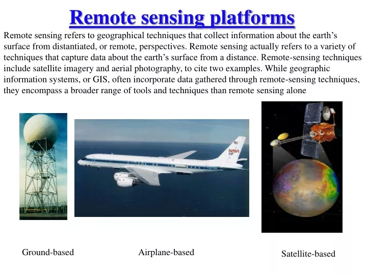
Remote sensing platforms Remote sensing refers to geographical techniques that collect information about the earth’s surface from distantiated, or remote, perspectives. Remote sensing actually refers to a variety of techniques that capture data about the earth’s surface from a distance. Remote-sensing techniques include satellite imagery and aerial photography, to cite two examples. While geographic information systems, or GIS, often incorporate data gathered through remote-sensing techniques, they encompass a broader range of tools and techniques than remote sensing alone Ground-based Airplane-based Satellite-based
Geographic Information Systems (GIS) are a new and blossoming concept, and continue to grow in complexity and utility thanks in large part to the proceeding and continual development of Remote Sensing. Remote Sensing plays a large role in the enhancement of any GIS, and in most cases, allows data to become much more relatable and useful for anyone. A GIS receives much of the data for its built-in layers from Remote Sensing platforms such as satellites, radars and airplanes. Passive sensors contribute to imagery and data for land cover mapping, change detection, snow monitoring, thermal changes and terrain modeling. Active sensors contribute heavily to data for extremely accurate terrain models known as Digital Elevation Models (DEMs). These large quantities of data can be geo-referenced and integrated into one large GIS, allowing a user to access a powerful amount of information at one time with relative ease. And as remote sensing technology continues to increase in resolution and power, the data base will enlarge and increase the potential power of users of a Geographic Information System.
Satellite Based • Sun-synchronous polar orbits • Most earth imaging satellites is polar-orbiting, meaning that they circle the planet in a roughly north-south ellipse while the earth revolves beneath them. Therefore, unless the satellite has some sort of "pointing" capability, there are only certain times when a particular place on the ground will be imaged • global coverage, fixed crossing, repeat sampling • typical altitude 500-1,500 km • example: Terra/Aqua, Landsat • Non-Sun-synchronous orbits • Tropics, mid-latitudes, or high latitude coverage, varying sampling • typical altitude 200-2,000 km • example: TRMM, ICESat • Geostationary orbits • regional coverage, continuous sampling • over low-middle latitudes, altitude 35,000 km • example: GOES. http://www.nesdis.noaa.gov/SatInformation.html
Passive: source of energy is either the Sun or Earth/atmosphere Sun - wavelengths: 0.4-5 µm Earth or its atmosphere - wavelengths: 3 µm -30 cm Active: source of energy is part of the remote sensor system Radar - wavelengths: mm-m Lidar - wavelengths: UV, Visible, and near infrared Types of remote sensing Camera takes photo as example, no flash and flash
αs αv elevation angle ( α) = 90-θ, some time, elevation angle is also called altitude
Solar incidence angle is the angle between the Sun and a line perpendicular to a surface. solar zenith angle is the solar incidence angle for a horizontal surface. For a slope surface, they are different. Azimuth angle definition difference: starts from north or from south
Spatial resolution and coverage • Spatial resolution • Instantaneous field-of-view (IFOV) • Pixel: smallest unit of an image • Pixel size • Spatial coverage • Field of view (FOV), or • Area of coverage, such as MODIS: 2300km or global coverage, weather radar (NEXRAD): a circle with 230 km as radius
1 meter, spatial resolution UTSA campus, red polygon is the Science Building 30 meter, spatial resolution Northwest San Antonio
Spatial Resolution Jensen, 2000
In cognitive space, perceived boundaries such as frontiers, horizons, borders, and shorelines are known as edges. Edges typically signify the outer limits of a particular place or region that distinguish it as finite and distinctive
GIS Basics • Geographic Information System • Allows the viewing and analysis of multiple layers of spatially related information associated with a geographic region/location • Both spatial and attribute (tabular) data are integrated • The widespread collection and integration of imagery into GIS has been made possible through remote sensing • With the increasing technological development of remote sensing, the development of GIS has simultaneously accelerated
Spectral resolution (Dl ) and coverage (lmin to lmax) • Spectral resolution describes the ability of a sensor to define fine wavelength intervals • The finer the spectral resolution, the narrower the wavelength range for a particular channel or band
Radiometric resolution and coverage • Sensor’s sensitivity to the magnitude of the electromagnetic energy, • Sensor’s ability to discriminate very slight differences in (reflected or emitted) energy, • The finer the radiometric resolution of a sensor, the more sensitive it is to detecting small differences in energy
Basics of Bit • Computer store everything in 0 or 1 (2bits) Bit no. 0 256 8 bits as an example Resolution: 12 bits Coverage: 0 - 4095
Temporal resolution and coverage • Temporal resolution is the revisit period, and is the length of time for a satellite to complete one entire orbit cycle, i.e. start and back to the exact same area at the same viewing angle. For example, Landsat needs 16 days, MODIS needs one day, NEXRAD needs 6 minutes for rain mode and 10 minutes for clear sky mode. • Temporal coverage is the time period of sensor from starting to ending. For example, • MODIS/Terra: 2/24/2000 through present • Landsat 5: 1/3/1984 through present • ICESat: 2/20/2003 to 10/11/2009
Remote Sensing Raster (Matrix) Data Format Y axis Jensen, 2000
Remote Sensing Scanning System Sabin, 1997 Pushbroom Wiskbroom Field of View (FOV), Instantaneous Field of View (IFOV) Dwell time is the time required for the detector IFOV to sweep across a ground cell. The longer dwell time allows more energy to impinge on the detector, which creates a stronger signal.
IFOV and FOV lens FOV= 2 tag-1 (D / 2f) (degree) IFOV= 2 tag-1 (d / 2f) ≈ d / f (radians). (d is the detector size, f is the focal length). The general unit of IFOV is milliradians (10-3 radians). 1º = (2π/360) = 0.01745 radians = 17.45 milliradians 1 milliradian = 0.057 º
Detector configurations: breaking up the spectrum • Discrete Detectors and scanning mirrors - MSS, TM, ETM+, GOES, AVHRR, SeaWiFS, AMS, ATLAS • Linear Arrays - SPOT, IRS, IKONOS, ORBIMAGE, Quickbird, ASTER, MISR • Liner and area arrays - AVIRIS, CASI, MODIS, ALI, Hyperion, LAC