Download
1 / 36
360 likes | 679 Views
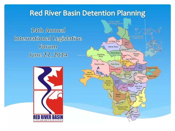
Red River Basin Detention Planning. 14th Annual International Legislative Forum June 27, 2014. Agenda. Basin wide Flow Reduction Strategy. A plan developed by the Red River Basin Commission to reduce future flood damages by reducing flows

E N D
Red River Basin Detention Planning 14th Annual International Legislative Forum June 27, 2014
Basin wide Flow Reduction Strategy A plan developed by the Red River Basin Commission to reduce future flood damages by reducing flows Accomplished primarily by detaining/retaining water upstream Requires construction of multiple storage facilities (impoundments) distributed throughout the basin
Adopting a Goal • Primary Criteria • Set a goal high enough to significantly reduce flood damages • Set it low enough to be considered doable and reasonably foreseeable • Initial Goal of 20% peak flow reduction along the entire length of the River • Would likely have prevented the 1997 disaster in Grand Forks / East Grand Forks • Considered doable by the committee, which included engineers representing tributary watersheds • Not a “Make or Break” goal • Lesser reductions will provide incremental benefits • Greater reductions will increase benefits
MainstemHydraulicModel • How much storage would be required?? • No suitable hydraulic model of the entire Red River Mainstem existed in 2005 to answer that question • RRBC FDR Committee, with assistance from consultants on contract, set out to develop a model… • That could dynamically account for both flow and storage across the broad valley as the flood wave moves north
Identifying Storage Potential The Basin Commission next encouraged each water district to identify storage it could build to meet its flow reduction allocation Existing hydrologic models (where available) were used by local water management engineers to prepare revised tributary hydrographs to the Red River that would result from the planned storage
BOIS DE SIOUX WATERSHED2010 Flow Reduction Strategy • 26 storage sites were identified to meet the 20% reduction goal at Wahpeton including one (North Ottawa) that has been constructed since 1997 and one hypothetical site in South Dakota. • The constructed storage volume would be 125,000 ac-ft of which 101,000 ac-ft would be gate controlled. • This compares to a flow reduction allocation of 98,000 ac-ft. • This suggests that total constructed storage may need to be about 25% greater than the flow reduction allocation or about equal to the gate controlled portion as expected.
Improved Hydrologic Models Completing and refining the tributary flow reduction plans clearly required new and improved hydrologic models for many tributary areas. Recently collected LIDAR data greatly improves potential model accuracy and detail. New HEC-HMS models are nearly completed using consistent and coordinated methodologies for all US tributaries. New HEC-HMS models are being developed north to the border and beyond as LIDAR data becomes available.
Refined Tributary flow Reduction Plans Using the new models, watershed are identifying sites that would meet their allocated flow reductions.
Tributary Distributed Detention Planning • Background Information • RRBMI LiDARMultiple Partners, Led by IWI • Phase 1 - HEC-HMS Existing ConditionsCommunities of Fargo and Moorhead • Site Identification Process and Level of Detail • Minnesota Tributary Expanded Distributed Detention Strategies • Funded By: Red River Watershed Management Board (Minnesota) • Red River Basin Commission • Buffalo-Red River Watershed District • North Dakota Tributary Comprehensive Detention Plans • Funded By: Red River Joint Water Resource District (ND) • Local Water Resource Districts • North Dakota State Water Commission
Detention Site Examples – On-Channel and Off-Channel Options Maple River Dam Maple River Water Resource District (North Dakota) Controls 815 square miles 60,000(+) Ac-Ft of un-gated storage North Ottawa Impoundment Project Bois de Sioux Watershed District (Minnesota) Controls 75 square miles 16,000 Ac-Ft of gated storage
Approximately 25 Locations • 300K A-F Total • 157K A-F Gated • 143K A-F Ungated Red River Basin Commission Basinwide Flow Reduction Strategy Peak Flow Goal: 35% Reduction Peak Flow Obtained: 29% Reduction
Red River Basin Commission Basinwide Flow Reduction Strategy Peak Flow Goal: 35% Reduction Peak Flow Obtained: 36% Reduction
Minnesota Funding • IWI Project Planning Tool Development - $180,000 • Distributed Detention Plan Development - $480,000 • Total - $660,000 • Funded By:Red River Watershed Management Board$617,000 • Buffalo-Red River Watershed District$21,600 • Red River Basin Commission (FMDA)$21,600
ND Watershed Detention Study Funding • TOTAL COST$1,700,000 • NDSWC (50%)$850,000 • RRJWRD (32.5% - 50%)$710,000 • Local (0% - 17.5%)$140,000 RRJWRD Sponsored Locally Sponsored
ND Comprehensive Detention Plan Methodology – • Site Identification Criteria • Control minimum of 20 square miles • Avoid impacts to residential structures / infrastructure • Store a minimum of 3 inches of runoff • Avoid mainstem locations in lower 2/3 of watershed • Primarily select off-channel & stream locations • Reasonable levee heights & inundation impacts • Modeling Assumptions • Gated with E.S. 5 feet below top of levee • Dry storage, no conservation pools
ND Comprehensive Detention Plan – Upstream Watersheds • Elm River Traill Co. WRD Cass Co. Joint WRD • Rush River Cass Co. Joint WRD • Maple River Maple River WRD • Lower Sheyenne Cass Co. Joint WRD • Wild Rice River Richland Co. WRD Cass Co. Joint WRD
ND Comprehensive Detention Plan – Upstream Watersheds • 100 ND Detention Site Options Identified • 7 Elm River • 3 Rush River • 40 Maple River • 20 Lower Sheyenne • 30 Wild Rice • Summary of Results for 100-yr Snowmelt • Tributary peak reductions in excess of 35% possible • Flood volume reductions in excess of 20% possible • LTFS tributary goals can be achieved • Off-channel sites needed to control peaks in many cases
Halstad Upstream Retention Study ND Comprehensive Detention Plans MN Expanded Distributed Detention Strategy HEC-RAS Red River Mainstem Hydraulic Model HEC-RAS Red River Mainstem Hydraulic Model Develop Halstad Upstream Retention Strategy
Halstad Upstream Retention Study Scope • To provide information to advance the Red River Basin Commission’s Long Term Flood Solutions Report • To provide assistance to the Fargo-Moorhead Diversion Authority on how to prioritize/allocate the approved $25 Million in Detention Funding • NOT to determine how upstream detention would alter current Fargo-Moorhead Metro Diversion Design
Halstad Upstream Retention Study Background • Related Studies Utilized • HEC-RAS Model Development (Phase 7)– Fargo-Moorhead Metro Project • Phase 1 - HEC-HMS Existing Conditions – US Army Corps of Engineers • Basinwide Feasibility Study • Detention Sites Provided By: • MN Expanded Distributed Detention Strategy • Funded By: Red River Watershed Management Board (Minnesota) • Red River Basin Commission • Buffalo-Red River Watershed District • ND Comprehensive Detention Plan • Funded By: Red River Joint Water Resource District (ND) • Local Water Resource Districts • North Dakota State Water Commission
Halstad Upstream Retention Study Assumptions • Sites Identified for Local Benefits First • Sites Identified by Local Watershed Districts & Water Resource Districts • Local Benefits First • Sites Initially Empty (No Normal Pool) • Drawdown of Gated Storage Not Considered • All Detention Sites Built • Full Implementation Required to • Generate Reported Benefits • Assumes full implementation • Conceptual Impoundment Locations • No Landowner Involvement • Ability to Implement • No Cost Evaluations • Limited Site Data • Modeling based on synthetic 100-year flood scenario • Based on Uniform/Standardized Runoff Assumption • Non-uniform runoff expected during actual events • Drawdown of Gated Storage Not Considered • Modeling completed based on the existing Red River condition • Potential changes to FM Diversion Project not evaluated
Halstad Upstream Retention Strategy One Scenario Resulting in a 20% Peak Flow Reduction 96 Locally Identified Sites
23% Peak Flow Reduction • 10% Flood Volume Reduction
Halstad Upstream Retention Study Summary • Red River mainstem 20% peak flow reduction is attainable for the analyzed event • Differing events will result in varying levels of flow reduction benefit • Estimated Stage Reduction of 1.0’ at Halstad, MN (1.3’ at Fargo, ND) • 96 Locally Identified Sites were used to for the proposed HUR Scenario • Stores a portion of runoff from 2,650 square miles • 560,000 Acre-Feet of Storage (455,000 Acre-Feet Gated) • 107,800 Acres Inundated within Storage Sites (170± Sections) • Conceptual Locations • Standardized Melt Progression Event represents one scenario to produce a 100-year flood at Fargo, ND • Varying events may also result in a 100-year flood at Fargo, ND • Provides tools necessary to evaluate specific projects for regional performance • The HUR Study does NOT evaluate retention as an alternative to the current F-M Metro Flood Control Project • Available for Download at www.redriverbasincommission.org
Implementation Hurdles • Funding Availability • Magnitude of funds need to fully implement • Funding eligibility (Project Development, Land Acquisition, etc…) • Non-traditional funding partners (FM Diversion Authority, Farm Bill, etc…) • Land Acquisition Methods – Site Specific Location • Education • Proactive Acquisition • Condemnation • Locally Acceptable vs Permit-ability • Location, location, location…
Basinwide Strategy... Next Steps • Phase III - International Border to Lake Winnipeg • To be completed by ??? • Phase II - Halstad, MN to International Border • To be completed by USACE Basinwide Feasibility Study • Phase I – Upstream of Halstad, MN • Completed by RRBC/FMDA
What can we do to maximize Nutrient Capture at Impoundment Sites
Minnesota, North Dakota and Manitoba all developing Nutrient Reduction Strategies • MPCA released Nutrient Reduction Strategy • Non-point Sources contribute 82% Phosphorus and 91% Nitrogen • Phosphorus Reduction Goals for Red River will be similar to Mississippi River Basin 45%
Design, Construct and Operate Treatment Cells within North Ottawa Impoundment with Bois De Sioux WD and their engineer Charlie Anderson, WSN • Develop surface water monitoring protocol to measure nutrient loading and removal effectiveness • Harvest cattails in individual cells at different times of the year and optimize nutrient capture and removal • Evaluate potential uses of cattails with Dr. Dan Svedarsky , University of MN - Crookston North Ottawa Project
Incorporate Detailed Monitoring System • North Ottawa Unique “Field Scale” Experimental Opportunity • “Closed System” Allows Detailed Upstream, Within Treatment Cell, and Downstream Monitoring • Development of Phosphorus Budget, Measurable/Quantifiable Results
Develop and maximize large scale Nutrient Reduction Strategy • Utilizing land already set aside for Flood Control Purposes • Use of treatment cells as a strategy to maximize Nutrient Reduction in High Loading Watersheds • Scalable, potentially significant Phosphorus Reduction Tool • 600 acres cattail harvested will remove 6600 pounds phosphorus,100% average load 75 square mile watershed above North Ottawa • This project is funded by MPCA 319 Fundand Mn Legislative/CitizenCommission on • Minnesota Resources, future funding • requests will be submitted to continue this • work