Download
1 / 1
10 likes | 78 Views

E N D
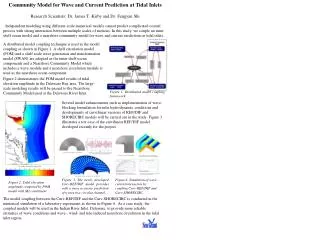
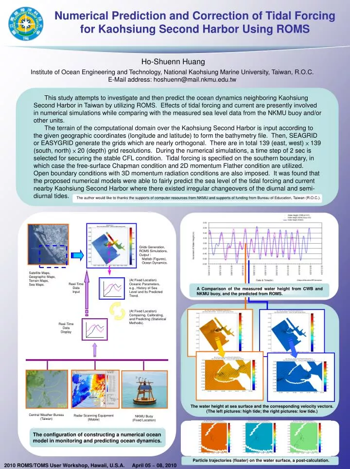
This studyattempts to investigateand then predict the ocean dynamics neighboring Kaohsiung Second Harbor in Taiwan by utilizing ROMS. Effects of tidal forcing and current are presently involved in numerical simulations while comparing with the measured sea level data from the NKMU buoy and/or other units. The terrain of the computational domain over the Kaohsiung Second Harbor is input according to the given geographic coordinates (longitude and latitude) to form the bathymetry file. Then, SEAGRID or EASYGRID generate the grids which are nearly orthogonal. There are in total 139 (east, west) × 139 (south, north) × 20 (depth) grid resolutions. During the numerical simulations, a time step of 2 sec is selected for securing the stable CFL condition. Tidal forcing is specified on the southern boundary, in which case the free-surface Chapman condition and 2D momentum Flather condition are utilized. Open boundary conditions with 3D momentum radiation conditions are also imposed. It was found that the proposed numerical models were able to fairly predict the sea level of the tidal forcing and current nearby Kaohsiung Second Harbor where there existed irregular changeovers of the diurnal and semi-diurnal tides. The author would like to thanks the supports of computer resources from NKMU and supports of funding from Bureau of Education, Taiwan (R.O.C.). A Comparison of the measured water height from CWB and NKMU buoy, and the predicted from ROMS. The configuration of constructing a numerical ocean model in monitoring and predicting ocean dynamics. Particle trajectories (floater) on the water surface, a post-calculation. Numerical Prediction and Correction ofTidal Forcing for Kaohsiung Second Harbor Using ROMS Ho-Shuenn Huang Institute of Ocean Engineering and Technology,National Kaohsiung Marine University, Taiwan, R.O.C. E-Mail address: hoshuenn@mail.nkmu.edu.tw Grids Generation, ROMS Simulations,Output : Matlab (Figures), Ocean Dynamics. Satellite Maps, Geographic Maps, Terrain Maps,Sea Maps. (At Fixed Location)Oceanic Parameters, e.g., History of Sea Level and Its Predicted Trend. Real-TimeDataInput (At Fixed Location)Comparing, Calibrating, and Predicting (Statistical Methods). Real-TimeDataDisplay The water height at sea surface and the corresponding velocity vectors.(The left pictures: high tide; the right pictures: low tide.) Central Weather Bureau (Taiwan) Radar Scanning Equipment (Mobile) NKMU Buoy (Fixed Location) 2010 ROMS/TOMS User Workshop, Hawaii, U.S.A. April 05 ~ 08, 2010