Download
1 / 28
300 likes | 445 Views
GLOBAL NAVIGATION system(GNS). What is navigation system?. The guidance of ships or airplanes from place to place

E N D
What is navigation system? • The guidance of ships or airplanes from place to place • Navigation is the process of reading, and controlling the movement of a craft or vehicle from one place to another. It is also the term of art used for the specialized knowledge used by navigators to perform navigation tasks.
Applications • Military(GPS) • Search and rescue. • Disaster relief. • Surveying. • Marine, aeronautical and terrestrial navigation. • Remote controlled vehicle and robot guidance. • Satellite positioning and tracking. • Shipping. • Geographic Information Systems (GIS). • Recreation.
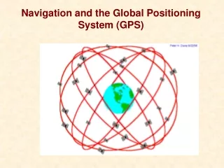
Military Global Positioning Satellite System (GPSS) GPS is a satellite navigation system developed by the US Dept. of Defense (DOD) established in 1973,run with24 sat. The Russian GLONASS,2007 GPS is used by aviators, mariners, surveyors, off-roaders, truck operators, bikers, hikers, hunters & fisherman
gps geos geos WAAS
Car Navigation • On-board navigation • Fleet management • Roadside assistance • Stolen vehicle recovery • Enhanced services • Mass market dominated
Expansion of Next-Generation ITS • Car Navigation system and ETC evolve and integrate, then various services will be realized all in one. • These services are realized by the high-speed and large-capacity communication (5.8GHz DSRC) between the “ITS Spot” installed on the roadside and the in-vehicle car navigation system corresponding to the ITS spot services • Various services such as providing wide-area traffic information or image are realized by the high-speed and large-capacity communication ITS spots are deployed nationwide (around 1,600 units are installed mainly on expressways) Car navigation system corresponding to ITS spot services have been released on October 2009 Car navigation system corresponding to the ITS Spot ITS Spot (roadside unit) High-speed and large-capacity communication (DSRC)
Main Functions of Map Summarizer dmax ASR ( Active Semantic Retrieval ) dmax Summarization Terminal Capability Feature Selection dmax Spatial Indexing dmax ShapeDeformation ORDBMS Media Conversion Spatial Media Start Kokubunji City Tokyo Int. Forum Goal Telematics ASP Center Hot Spot Wireless LAN CDMA2000 1x EV-DO Cell Phone Base Station Mobile Router Seamless transfer to Walking Driving assist to the target Change Summarizing Levels based on Terminal Capabilities Shape Deformation Techniques Orthogonize Road Angles Simplify Road Shape Summarize for Cell Phone Optimization formula dmax Relative angular among vectors Spring Model of Road Shape original Cell Phone Walker Guide :NodeID Original Car Navigational Maps result Summarize for PDA If longest Distance; dmax≧ e, then leave corresponding points result original PDAs Walker Guide
Consumer/Recreational Portable receivers for fishermen, hunters, hikers, cyclists, etc. Recreational facilities -- golf courses, ski resorts Integration of GPS into cellular phones
Surveying/Mapping/GIS • Sub-centimeter accuracy • 100%-300% savings in time, cost, & labor • Rural electrification • Telecom tower placement • Pipelines • Oil, gas, and mineral exploration • Flood plain mapping
Tracking/Machine Control • Package/cargo delivery • Fleet and asset management • Theft recovery • Public safety and services • Farming, mining, and construction equipment • DGPS/RTK required for many applications
Public Services • City planning • Transportation infrastructure • Road Billing Network (ROBIN) • Snowplows • Emergency response • Law enforcement • Fire fighting • Search and rescue • Paramedics • Disaster relief
Maritime Navigation • GPS-based vessel tracking and traffic management maximizes effectiveness of waterways • Improved safety increases maritime commerce • Maritime DGPS service for enhanced accuracy and safety available in 34 countries
Timing • GPS offers an inexpensive alternative to costly, high maintenance timing equipment • Telecommunications network synchronization & management • Phones, pagers, wireless systems • LANs, WANs, Internet • Financial transactions • Electrical power grid management & fault location • Digital signatures for e-commerce
Monitoring geological change Glaciers, tectonic plates, earthquakes, volcanoes Wildlife behavior Atmospheric modeling Water vapor content Oceanic studies Tidal patterns Surface mapping Scientific Research
Construction • Machinery, asset, and personnel management • Rapid surveys for laying foundation piles, etc. • Accident prevention • Remote control of machinery possible GPS/RTK technology was used in the construction of the Øresund Bridge between Denmark and Sweden
Precision Agriculture • Maximize use of resources • Optimized plowing of crop rows • Tailored applications of seeds, fertilizer, water, pesticides • Improved management of land, machinery, personnel, time • Greater crop yields • Minimize environmental impacts • Localized identification and treatment of distressed crops reduces chemical use • Precise leveling of fields prevents fluid runoff
Open Pit Mining • Enhanced management of assets, equipment • Progress tracked in real-time, remotely • Improved machine control saves time, lowers maintenance and fuel consumption, prevents accidents • Rapid surveying for drilling blast holes • Smaller, more empowered workforce
Space Applications • Improved orbit and attitude control for spacecraft, International Space Station • Space Station return vehicle • Advance Land Observing Satellite uses GPS to calibrate high resolution radar maps • Satellite formation flying
Direct-sequence spread spectrum In telecommunications, direct-sequence spread spectrum (DSSS) is a modulation technique. As with other spread spectrum technologies, the transmitted signal takes up more bandwidth than the information signal that is being modulated. The name 'spread spectrum' comes from the fact that the carrier signals occur over the full bandwidth (spectrum) of a device's transmitting frequency
GPS Transmitted Signal • Two signals are transmitted on carriers: L1 = 1575.42 MHz L2 = 1227.60 MHz These are derived from the system clock of 10.23 MHz (phase quadrature) • Modulation used is Direct Sequence Spread Spectrum (code division multiple access - CDMA)