Download
1 / 16
160 likes | 291 Views
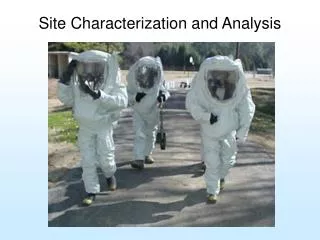
Update on validation of MERIS r w ’s at the BOUSSOLE site David Antoine 1 , Constant Mazeran 2 , Christophe Lerebourg 2 , Ludovic Bourg 2 , Marc Bouvet 3 , Fabrizio D'Ortenzio 1 , Samantha Lavender 4 , Kathryn Barker 4 , Bernard Gentili 1 , Vincenzo Vellucci 1.

E N D
Update on validation of MERIS rw’s at the BOUSSOLE site David Antoine1, Constant Mazeran2, Christophe Lerebourg2, Ludovic Bourg2 , Marc Bouvet3, Fabrizio D'Ortenzio1, Samantha Lavender4, Kathryn Barker4, Bernard Gentili1, Vincenzo Vellucci1 1: Laboratoire d’Océanographie de Villefranche, Villefranche sur mer, France 2: ACRI-st, Sophia Antipolis, France 3: ESA-ESTEC, Noordwijk, The Netherlands 4: ARGANS Ltd, Plymouth, UK
A reminder about BOUSSOLE Motivation, objectives: establishing a long-term time series of optical properties (IOPs and AOPs), with two parallel objectives: - Scientific objective: IOPs et AOPs documentation and understanding (bio-optics research), short-time changes... - Operational objective: vicarious radiometric calibration of ocean color satellite observations, and validation of the Level-2 geophysical products derived from these observations (e.g., chlorophyll, reflectances...). Strategy: combination of 3 elements: - A Deep-sea mooring, for continuous collection of data at the surface - Monthly cruises for the buoy servicing and the collection of data complementary to the buoy data - An AERONET coastal station, to provide the necessary aerosol parameters
The BOUSSOLE site in the Ligurian Sea (northwestern Mediterranean)
Waters at BOUSSOLE are permanently Case 1 waters Morel & Maritorena, 2001 Upper limit for Case 1 waters Buoy data Irradiance reflectance at 560 nm as a function of Chl
The range of bio-optical properties at BOUSSOLE is representative of global Case 1 waters Thick line : BOUSSOLE Thin line and thin dotted line : SeaWiFS global or Med Sea only Gray : NOMAD
Buoy data are in agreement with more “classical data”, i.e., profiling radiometer’s data reflectance from the buoy Slope is 1 r2 is 0.98 Bias is 8 10-4 reflectance from a free-falling radiometer (Satlantic SPMR)
Status of buoy deployments • 5 years of deployment, with a quasi permanent data collection • (September 2003 September 2008) • Over these 5 years (1825 days), we had 1560 days with a buoy at sea. This is a 85% “deployment success”, i.e., nearly operational • Over these 1560 days, 1300 were with data acquisition. This is a 83% “acquisition success”, which is also very satisfactory - Bi-monthly servicing since July of 2007 • No data from January 15 to June 15 2008 (5 months) - Next rotation is scheduled Jan 2009 - Evolution towards hyper-spectral measurements has started in June 2008 (350800 nm, res 2 nm). Nominal set of 7-l multispectral data is however preserved for continuity
Matchup procedures Essentially follows: Bailey S.W., and P.J. Werdell, 2006: A multi-sensor approach for the on-orbit validation of ocean color satellite data products. Remote Sens. Environ., 102, 12-23. - 5x5 pixel box - Flags: glint, clouds, haze, qs<70°, qv<60°, clear sky • Spatial homogeneity is checked - MERIS: level-2 RR, last reprocessing 109 matchups • SeaWiFS: level-2 Merged Local Area Coverage (MLAC; until • Dec. 2004) or Global Area Coverage (GAC; 2005-2006) data from reprocessing 5 (completed March 18, 2005) 193 matchups - MODIS-A: level-2 GAC data from reprocessing 1 (completed in February 2005) 185 matchups
4-year time series of rw MERIS SeaWiFS MODIS-A Field data (10am – 2pm, clear sky)
Full matchup set, using data from Sept 2003 to Dec 2007
Conclusions - The requirements in terms of accuracy of the atmospheric correction are only met at 443 and 490 nm by the SeaWiFS and MODIS-A products. - The MERIS products don’t meet the requirements. - The water-leaving radiance reflectances provided by the three sensors at 412 nm are severely affected by atmospheric correction errors. - The uncertainty is significantly reduced for the “blue-to-green” reflectance ratio. - These results and the matchup statistics are in agreement with the results obtained by two other similar efforts carried out at a coastal site [Zibordi et al., 2006] and globally [Bailey and Werdell, 2006]. Vicarious calibration should be included in the MERIS L2 processing, as it is done for other OC sensors presently in orbit See next presentations
Further information Antoine, D. M. Chami, H. Claustre, F. D’Ortenzio, A. Morel, G. Bécu, B. Gentili, F. Louis, J. Ras, E. Roussier, A.J. Scott, D. Tailliez, S. B. Hooker, P. Guevel, J.-F. Desté, C. Dempsey and D. Adams. 2006, BOUSSOLE : a joint CNRS-INSU, ESA, CNES and NASA Ocean Color Calibration And Validation Activity. NASA Technical memorandum N° 2006–214147, 61 pp. Antoine, D., P. Guevel, J.-F. Desté, G. Bécu, F. Louis, A.J. Scott and P. Bardey, 2008, The « BOUSSOLE » buoy – A new transparent-to-swell taut mooring dedicated to marine optics : design, tests and performance at sea, Journal of Atmospheric and Oceanic Technology, 25, 968-989. Antoine, D., F. D’Ortenzio, S.B. Hooker, G. Bécu, B. Gentili, D. Tailliez and A. Scott, 2008, Assessment of uncertainty in the ocean reflectance determined by three satellite ocean color sensors (MERIS, SeaWiFS, MODIS) at an offshore site in the Mediterranean Sea (BOUSSOLE project), Journal of Geophysical Research, 113, C07013, doi:10.1029/2007JC004472. Bailey S., S.B. Hooker, D. Antoine, J.P. Werdell and B. Franz, Vicarious calibration of ocean color satellite remote sensors: An analysis of sources and assumptions, Applied Optics, 47(12), 2035-2045.
www.obs-vlfr.fr/Boussole Thank you for your attention