Download
1 / 23
230 likes | 312 Views
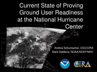
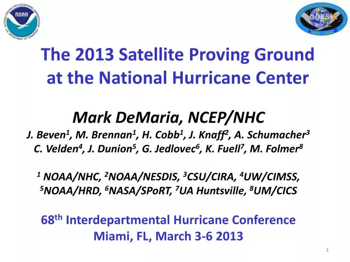
The 2013 Satellite Proving Ground at the National Hurricane Center. Mark DeMaria , NCEP/NHC J. Beven 1 , M. Brennan 1 , H. Cobb 1 , J. Knaff 2 , A. Schumacher 3 C. Velden 4 , J. Dunion 5 , G. Jedlovec 6 , K. Fuell 7 , M. Folmer 8

E N D
The 2013 Satellite Proving Ground at the National Hurricane Center Mark DeMaria, NCEP/NHC J. Beven1, M. Brennan1, H. Cobb1, J. Knaff2, A. Schumacher3 C. Velden4, J. Dunion5, G. Jedlovec6, K. Fuell7, M. Folmer8 1 NOAA/NHC, 2NOAA/NESDIS, 3CSU/CIRA, 4UW/CIMSS, 5NOAA/HRD, 6NASA/SPoRT, 7UA Huntsville, 8UM/CICS 68th Interdepartmental Hurricane Conference Miami, FL, March 3-6 2013
Outline • Overview the NHC GOES-R Proving Ground • Summary of 2013 products • Forecaster feedback and examples • Plans for 2014
Overview of GOES-R • Next generation of GOES satellites • Planned launch in late 2015 • Advanced Baseline Imager (ABI) • 16 channels, improved spatial and temporal resolution • Geostationary Lightning Mapper (GLM) • Near continuous monitoring of total lightning • Space Weather Instruments • Communications Capabilities
Goals of NHC PG Experiment • Demonstrate GOES-R surrogate products in real-time at NHC during the 2013 hurricane season • Product set determined by coordination between NHC forecasters, developers and GOES-R Program Office • Proxy GOES-R ABI data from MSG, current GOES • Proxy GOES-R GLM data from ground-based WWLLN • Ensure that NHC forecasters can use and get familiar with GOES-R products using proxy data • Evaluate products and provide valuable feedback to GOES-R Program Office and developers
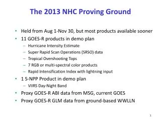
2013 NHC Proving Ground Products Phase 1 (Started Aug 1, 2013) • Hurricane Intensity Estimate (HIE) • Super Rapid Scan Imagery (SRSO) • Tropical Overshooting Tops (TOT) • GOES-R Natural Color Imagery • Red-Green-Blue (RGB) Air Mass Product* • RGB Dust Product* • Saharan Air Layer (SAL) Product* • Rapid Intensification Index (RII) • Pseudo Natural Color Imagery * Phase 2 (Started Sep 1, 2013) • RGB Cloud Top Microphysics Product • RGB Convective Storms Product • VIIRS Day/Night Band (S-NPP Product) *Provided in N-AWIPS formatthrough SPoRT
2013-2014 Project Schedule • Jun 1, 2013 - Phase 1 products into NHC • Jul 31, 2013 - Project Briefing to NHC • Aug 1, 2013 - NHC PG Phase 1 began • Aug 20, 2013 - Training for NHC on Phase 2 products • Sep 1, 2013 - NHC PG Phase 2 began • Sep 17, 2013 - Mid-project review at NHC • Oct 31, 2013 - Mid-project report completed • Nov 30, 2013 - NHC PG ended • Jan 2013 - Project debriefing • Mar 5, 2014 - IHC Presentation • Mar 31, 2014 - 2013 Final Report to be completed • Mar 29, 2014 - Meeting for 2013 product selection • Aug 1, 2014 - 2014 PG begins
Collection of NHC Forecaster Feedback • Mid-project review (17 Sep 12) and de-briefing conference call (22 Jan 13) • Blogs • http://rammb.cira.colostate.edu/research/goes-r/proving_ground/blog • http://nasasport.wordpress.com • Informal communications with developers • NHC feedback form
The 2013 Hurricane Season • Very quiet season in the Atlantic • No rapid intensification cases • No major hurricanes • East Pacific also quiet • Only one major hurricane No SRSO cases from GOES-14 due to slow season
Hurricane Intensity Estimate (HIE) • Provides TC analysts with an objective and operationally-proven TC intensity estimation tool using GOES-R ABI IR imagery. • Has been demonstrated to NHC/TAFB specialists within the GOES-R Proving Ground since the 2010 Atlantic TC season. • As proxy data for GOES-R, employs 15-minute IR imagery from Meteosat-9/10 and GOES-East (CONUS sector) • 15 min imagery frequency increases responsiveness • Algorithm heritage based on the Advanced Dvorak Technique (ADT) • Developed by UW-CIMSS, used operationally by NHC • Systematic verification is underway as part of PG feedback • Feedback in 2013 • Higher refresh rate useful during Humberto… “Higher refresh rate of RPG HIE allowed for quicker identification of developing eye scene with Humberto, and thus a higher CI than AODT.” -Stripling/DeMaria, TAFB Pacific, Sep 13 2013 1000 UTC
RGB Products • Forecasters will not have time to view all 16 ABI channels • Red-Green-Blue (RGB) image combination products being developed to highlight features of interest • 7 RGB and related image products in 2013 PG • Air Mass (MSG, GOES Sounder) • Dust (MSG) • Saharan Air Layer (MSG) • Pseudo Natural Color (MSG) • Natural Color (MODIS) • *Cloud-top Microphysics (MSG) • *Convective Storms (MSG) *New products for 2013
RGB Product Examples Natural Color Hurricane Humberto, 12 Sep 2013 (MODIS example, GOES-R will loop) Air Mass (top) and Dust (bottom) TS Erin, 16 Aug 2013
New RGB for 2013Cloud-Top Microphysics Product • Provides information about cloud-top particle, cloud-top phase, and precipitation • Tropical applications • Intensity forecasting (cloud-top paritcle size related to updraft strength) • Monitoring marine environment • Generated from MSG Seviri channels VIS0.8, IR3.9, IR10.8 • Highlights differences in cloud top particle size and phase • Cloud top structure (Red) • Particle size (Green) • Cloud top temperature and phase (Blue)
New RGB for 2013Daytime Convective Storms Product • Provides information about • Cloud top particle size (related to updraft strength) • Cloud top phase • Precipitation • Tropical applications • Cloud discrimination (convective, straitform) • Genesis and intensity forecasting • Generated from MSG Seviri channels WV6.2, WV73, IR3.9, IR10.8, NIR1.6, VIS0.6 • Highlights differences between dry, tropical, and cold air masses TS Jerry, 3 Oct 2013
Feedback on RGB Products • More efficient access to products obtained through new LDM feed to NHC from SPoRT • RGB Air Mass • Used often by HSU and TAFB • Showed dry air impinging on Erin, suggesting intensification less likely • RGB Dust • Used often by HSU and TAFB • SAL product • Pseudo natural color • Natural color • Cloud-top Microphysics • Convective Storms • HSU noted image distorting near sunrise and sunset, developers working on issue
Tropical Overshooting Top (TOT) Detection Algorithm Example from 2013 NHC Proving Ground – TS Juliette • Objectively identifies overshooting top locations using cold IR pixels relative to neighbors, to isolate and quantify active vigorous tropical convection. • As proxy data for GOES-R, the TOT algorithm employs 15-minute IR imagery from Meteosat-9/10 and GOES-East (CONUS sector). • Research underway to associate TOT trends with TC genesis and rapid intensification, and as a potential predictor in statistical prediction models. • Feedback in 2013 • TOT showed signal on bursting convection near the center of Juliette GOES-E color-enhanced IR image and identified TOTs (yellow dots) at 0615UTC on 29 Aug., 2013
Lightning-based Rapid Intensification Index • Ground based WWLLN used as proxy for the GLM • Rapid Intensification Index (RII) algorithm modified to include lightning predictors • Rain band lightning favors RI • Inner core lightning signals end of RI period • Large lightning outbreaks for sheared storms • Consistent with rapid intensification algorithm • Radial scaling may be needed for small East Pacific storms • Systematic verification of 2013 RII underway • Feedback in 2013 • XXXX Rain band Region Inner core Region
Lightning Outbreak Indicated Increased Shear in NHC’s TD Eleven Forecast Discussion 000 WTNT41 KNHC 300840 TCDAT1 TROPICAL DEPRESSION ELEVEN DISCUSSION NUMBER 6 NWS NATIONAL HURRICANE CENTER MIAMI FL AL112013 500 AM AST MON SEP 30 2013 THE CONVECTIVE CLOUD SHIELD REMAINS SHEARED NORTHEAST THROUGH SOUTHEAST OF THE CENTER. THERE HAS BEEN A NOTICEABLE INCREASE IN LIGHTNING ACTIVITY DURING THE PAST COUPLE OF HOURS...WHICH IS OFTEN INDICATIVE OF INCREASING VERTICAL WIND SHEAR. … $$ FORECASTER STEWART
GOES-East Outage on May 22Lightning data provided continuity of convective activity in gap between GOES-west and MSG
VIIRS Day-Night Band ReflectanceHurricane Manuel (East Pacific) in N-AWIPS • New low-light sensing capabilities on S-NPP • Senses reflected moonlight at night • Can be used in similar ways to visible channel during the day • Nighttime TC center fixing and structure identification • Cloud monitoring
Possible New Products for 2014 • New RGB products • CIRA combined microwave/IR product • Improved dust product (CIRA DEBRA) • S-NPP • Selected imagery from VIIRS • High resolution vis/IR • ATMS/CrIS soundings • Adaptation of CIRA and CIMSS algorithms • Maximum potential intensity estimate • VIIRS/ATMS automated center fixing algorithm
Example of Blended Geo-Leo RGB Product Tropical Cyclone Rusty Feb 2013 Red = IR window channel , Green = IR water vapor channel, Blue = 85 to 91 GHz μ-wave
LDM Feed from SPoRT • Most PG products obtained through SPoRT • wget script at NHC could not be modified due to lack of technical support staff experience • M. DeMaria was acting TSB chief Aug 14-Sep 25 • Permission obtained from NCEP/NCO to open LDM feed to SPoRT • NHC/SPoRT coordination allowed replacement of wget script • New products for NHC now available • Bandwidth analysis showed 30% reduction due to LDM efficiency • LDM Feeds requested from CIRA and CIMSS
Summary • 11 GOES-R and 1 S-JPSS products demonstrated in 2013 NHC Proving Ground • Experience gained by forecasters • Valuable feedback obtained from forecasters • Very quiet season in Atlantic, East Pacific also quiet • No SRSO cases from GOES-14 due to slow season • Air Mass and Dust RGB products used often by HSU and TAFB • Considerable feedback on lightning data • Useful for continuity during GOES-east outage • Large lightning outbreaks for sheared storms • Consistent with rapid intensification algorithm • Radial scaling may be needed for small East Pacific storms • Hurricane Intensity Estimate higher refresh rate useful during Humberto • More efficient access to products obtained through new LDM feed to NHC from SPoRT