Download
1 / 29
290 likes | 295 Views
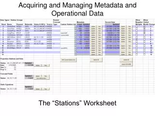
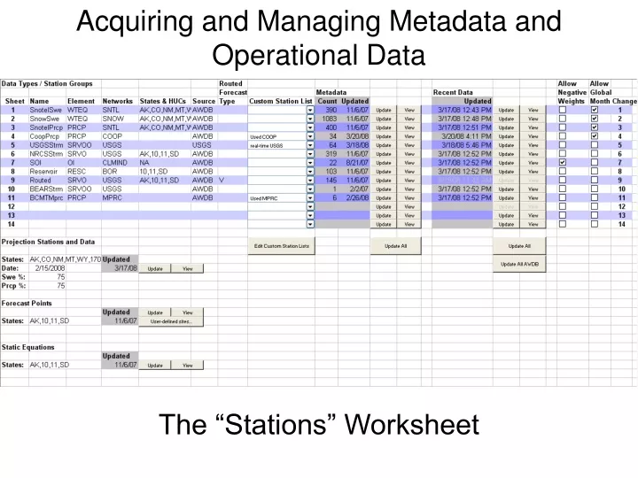
Acquiring and Managing Metadata and Operational Data. The “Stations” Worksheet. Acquiring and Managing Metadata and Operational Data. Data Types/Station Groups. The “Stations” Worksheet. Data Types/Station Groups. Up to 14 station groups.

E N D
Acquiring and Managing Metadata and Operational Data The “Stations” Worksheet
Acquiring and Managing Metadata and Operational Data Data Types/Station Groups The “Stations” Worksheet
Data Type names should describe the variable being used and should make sense to the user.
Location of data stations States/Provinces: AK, CO, UT, MT, AB, etc. HUCs: 14, 140100, 14010003
Source of data AWDB: NWCC Web Service USGS: USGS Web Service ACIS: In the future
Acquiring and Managing Metadata and Operational Data Custom Station List The “Stations” Worksheet
Used to limit the stations selected for a certain element and to speed up operational speed of the Viper application. When custom station lists are used, the States & HUCs cells are ignored.
Acquiring and Managing Metadata and Operational Data Metadata The “Stations” Worksheet
Used to update station metadata. Each time a state or HUC is added to the “States & HUCs” cell, or the custom station lists are modified, the affected groups have to be updated.
Acquiring and Managing Metadata and Operational Data Recent Data The “Stations” Worksheet
Updated date and time Metadata updated Update single group
Two years of recent, operational data. Contains data from the current calendar year and the previous calendar year.
Acquiring and Managing Metadata and Operational Data Negative statistical weighting/Global month change The “Stations” Worksheet
Global Month Change will be explained in the Viper main interface presentation. Negative hydrologic variables will not be allowed in the model analysis, unless this box is checked for the group. This usually pertains only to temperature and climate teleconnection variables.
Acquiring and Managing Metadata and Operational Data Static Equations The “Stations” Worksheet
Updating from these locations would get the current stream flow forecast equations from Alaska (AK), the Missouri Basin (10), the Arkansas Basin (11) and South Dakota (SD). Updating the current static equations from the database (AWDB) should probably be avoided, unless you are familiar with the forecast equations in Viper and know that the current models have been uploaded. A mistake here could cost you dearly!!!
Acquiring and Managing Metadata and Operational Data Forecast Points User-Defined Forecast Points The “Stations” Worksheet
Forecast points can be downloaded into Viper by state id, HUC (basin) or username (forecast developer). If the desired forecast point isn’t resident in the database (AWDB), it can be added to Viper by adding the necessary metadata information on the “User-defined sites…” window shown below.
Acquiring and Managing Metadata and Operational Data Data Projection The “Stations” Worksheet
Projection of Snotel data is an option in Viper to update forecasts at times other than the first of the month. Snotel data can be projected from the current day to the first day of the next month, using average daily values. This will allow the user to use the next month’s forecast models to update the seasonal forecasts. Average (100% - default) can be used to project Snotel data, or, if the user prefers, SWE and/or Prcp percentages can be specified between 0% and 100%.
Acquiring and Managing Metadata and Operational Data QUESTIONS? The “Stations” Worksheet