Download
1 / 14
140 likes | 147 Views
Section 3 EO-1 Mission Overview. What is EO-1?. Designed to flight validate breakthrough technologies applicable to Landsat follow-on missions

E N D
Section 3 EO-1 Mission Overview
What is EO-1? • Designed to flight validate breakthrough technologies applicable to Landsat follow-on missions • Specifically responsive to the Land Remote Sensing Policy Act of 1992 (Public Law 102-55) wherein NASA is charged to ensure Landsat data continuity through the use of advanced technology: • Multispectral Imaging Capability to address traditional Landsat user community • Hyperspectral Imaging Capability to address Landsat research-oriented community -- backward compatibility essential • Calibration test bed to improve absolute radiometric accuracy • Atmospheric correction to compensate for intervening atmosphere Visit our Web Site @ http://eo1.gsfc.nasa.gov/
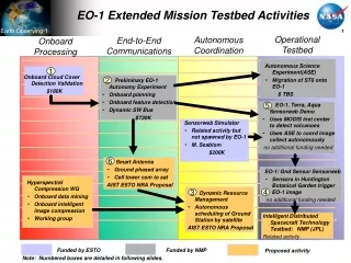
X-Band Phased Array Antenna (II) RS-422 C&DH S-Band Antenna Atmospheric Corrector (III) Enhanced Formation Flying (III) Pulse Plasma Thruster (III) GPS Carbon-Carbon Radiator (III) Precision Pointing EO-1 Technologies Advanced Land Imager Multispectral Imaging Capability (I) Wide Field Reflective Optics (I) Silicon Carbide Optics (I) G R O U N D Wide Band Advanced Recorder/ Processor I/F B 0 X Hyperion (III) Grating Imaging Spectrometer • EO-1 TECHNOLOGIES • Multispectral Imaging Capability • Wide Field Reflective Optics • Silicon Carbide Optics • Grating Imaging Spectrometer (HYPERION) • Atmospheric Corrector (AC) • X-Band Phased Array Antenna • Enhanced Formation Flying (EFF) • Pulse Plasma Thruster (PPT) • Carbon-Carbon Radiator (CCR) • Lightweight Flexible Solar Array • Wideband Advanced Recorder / Processor (WARP) • Global Positioning System (GPS) • Precision Pointing Attitude Control System Lightweight Flexible Solar Array (III)
NMP Technology Categories CATEGORY I CATEGORY III CATEGORY II • Essential Technology • Willing to restructure mission in order to fly it • If technology gets into trouble -- you fix it • Part of minimum mission • Technology exercises a flight opportunity • If technology gets into trouble -- you defer it to a later flight • Technology provides an essential mission function • A conventional approach is pre-planned • If technology gets into trouble -- you switch to the conventional approach
M a i n F o c a l P l a n e A s s e m b l y +Z +X SiC Optics 1 5 ° Wide FOV 1.256° x 15° ALI Without MLI Multispectral/ Panchromatic 6 VNIR + 3 SWIR 220 K BandGround Sampling Pan 10 m MS 30 m +Y ° 1 . 2 5 6 Advanced Land Imager (ALI)
Hyperion Imaging Spectrometer • Convex Grating spectrometers with CCD VNIR and HgCdTe SWIR detectors • 30m spatial and 10nm spectral resolutions over 7.5km swath and 400-2500nm spectral range • Multiple calibration options: lamps, lunar, solar, ground imaging and laboratory • Hyperspectral Imaging Capability to address Earth Observation applications
LEISA Atmospheric Corrector • Correction of multispectral surface imagery for atmospheric variability (water and aerosols) • High spectral, moderate spatial resolution (250m), large swath (180km) hyperspectral imager using wedge filter technology • Spectral coverage of 0.89 - 1.6µm, bands selected for optimal correction of high spatial resolution images
EO-1 Spacecraft • Power • 315 Watts • 50 Ahr • Super NiCd • Data Storage • Housekeeping: 1 Gbit • Science: 48 Gbits • Articulating Si Solar Array • Mass • 588 Kg • ALI Pointing • Roll / Yaw: 0.022° • Pitch: 0.033°
Spacecraft Technologies • Wideband Advanced Recorder / Processor (WARP) • X-Band Phased Array Antenna • Enhanced Formation Flying • Pulse Plasma Thruster • Carbon-Carbon Radiator • Lightweight Flexible Solar Array • Global Positioning System • Precision Pointing
Science Validation Team NRA Investigators Stennis Mission Science Office Instrument Scientists Calibration Scientists, JPL Mission Operations Center (MOC) at GSFC Real-time Telemetry Launch Support EO-1 Scene Requests Processed Data WARP PB, sent via mailed tapes TDRSS/ WSC • Core Ground System (CGS) • Command and control • Health and Safety monitoring • Trending • CMS • S-Band Science Data Processing • Data Processing System (DPS) • X-Band Science Data Processing • Level 0 + • Mission Ops Planning & Support • System (MOPSS) • Planning and Scheduling • Flight Dynamics System (FDS) • Orbit • Attitude EO-1 Mission Science Office X and S Band Playback Real-time Telemetry Command RT SOH - VC0 PB SOH Post Pass- VC1 Sig Events - VC2 N Science Scheduling Plan I X or S Band Playback • Mission Science Planning Office • Science Planning S Daily target list and DCE ancillary data N Real-time Telemetry and Command Mail High Rate Data Tapes Mail High Rate Data Tapes Tables Memory Loads Commands Landsat 7 State Vctrs Alaska (Prime) • Science Validation Facility • Functions for the SVT: • ALI Level-1 Processing • Data Archive • Data Distribution • Image Assessment • Calibration Real-time Telemetry and Command T Processed Data C P Doppler / Angles / I P Hyperion L0 data Svalbard, Wallops (Backup / Launch) Formation Flying Coordination Schedules of Landsat 7 Scenes Landsat 7 State Vectors Hyperion L0 & L1 data Mailed Science Data Tapes McMurdo (Launch / Maneuvers) Landsat 7 MOC at GSFC TRW • Process Hyperion level 1 data • Commercialization planning Operations Overview Ops Overview
X-Band: Receive 160 Gbits per day for the first 120 days and 80 Gbits per day at 105 Mbps thereafter • Record the received X-band data on hard media, mail to GSFC, and store raw data for 30 days • S-Band: Receive data at selected rates up to 4 Mbps • Housekeeping data: Route selected virtual channels to GSFC in real time, record up to 200 Mbits of data each day, and FTP recorded data to GSFC within one hour. Store raw data for 30 days. • Backup science data (up to 10 Gbits per day): Process as with X-band. • Perform Level 0 processing on the science and HK telemetry • Fill holes, reorder science into band order Ground System Requirements Summary Ground stations to receive, process, and route science and HK data to GSFC
Process MS/PAN science data to provide at least 200 paired scene comparisons with Landsat-7 • HYPERION Science Processing at TRW • Maintain an orbit of sufficient precision for scene comparisons • Follow Landsat-7 Ground Track ± 3 km and 1 minute behind • Maintain the health and safety of the spacecraft • Validate and calibrate onboard orbit and attitude subsystems • Perform orbit maneuver control to enable formation flying • Provide mission planning and command management • Archive raw and processed data Ground System Requirements Summary (continued) GSFC to receive and process data sent from the ground station
Operational Phases • Launch & Early Orbit • Launch and the first several orbits, spacecraft checkout, and instrument turn-ons • Approximately 15 days (20 days to get to 1 minute behind Landsat) • 1 minute behind Landsat 7 • Instrument Checkout • Full instrument checkout • Approximately 60 days • Nominal Ops • Science Validation • 10 months • End of Life • Deorbit burn for reentry within 25 years
Summary of Mission Overview • The EO-1 mission is responsive to the 1992 Land Remote Sensing Act wherein NASA will use advanced technology to ensure Landsat data continuity • It will flight validate improvements in: • Multispectral imaging • Hyperspectral imaging • Calibration • Atmospheric Correction • Spacecraft technologies useful to remote sensing • The mission was successfully launched on November 21, 2000 • Selected EO-1 imagery will be available soon at: http://eo1.gsfc.nasa.gov/miscPages/images.html