Download
1 / 22
220 likes | 378 Views
A New Product for Estimating the Probability of Tropical Cyclone Formation. Mark DeMaria , NESDIS/ORA, Fort Collins, CO Charles W. Anderson , Dept of Computer Science, CSU John A. Knaff and Bernadette H. Connell , CIRA/CSU Outline Background Information Datasets and Forecast parameters

E N D
A New Product for Estimating theProbability of Tropical Cyclone Formation • Mark DeMaria, NESDIS/ORA, Fort Collins, CO • Charles W. Anderson, Dept of Computer Science, CSU • John A. Knaff and Bernadette H. Connell, CIRA/CSU • Outline • Background Information • Datasets and Forecast parameters • Screening and Discriminant Analysis • Forecast Example and Verification • Operational Product Implementation
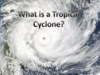
TC Formation Product • Determine whether or not a tropical cyclone will form within the next 24 hours in a 5o by 5o lat/lon area • Atlantic and East Pacific Basins • Objective Guidance for NHC Tropical Weather Outlook
Objective Genesis Forecast Methods • Gray (1968) • Defined large scale factors to explain seasonal cycle of formation • Simpson (1971), Hebert (1978) • Decision ladder approach combining satellite data and model analyses • DeMaria, Knaff and Connell (2001) • Parameter for the tropical Atlantic, combining satellite data and model analyses • Hennon and Hobgood (2003) • Linear discriminant analysis in disturbance-relative environment
Data Sets • NHC Best Track 1949-2003 • East Pacific and Atlantic • Subtropical/Extratropical cases excluded • Unnamed depressions included since 1989 • NCEP Global Model Analyses 1980-2003 • Reanalysis 1980-1999 (2.5o grid) • Operational Analyses 2000-2003 (2.0o grid) • GOES-East Water Vapor Imagery 1995-2003 • Re-mapped Mercator projection (16 km) • GOES-8 1995-2002 • GOES-12 beginning in 2003
Definition of Formation • Development of a closed warm-core circulation in the tropics and subtropics with sustained convection • Practical Definition: • The first point in the NHC best track • Excludes extra-tropical, subtropical, wave, remnant low, disturbance designations
Climatological 24-hr Formation Probabilities May Sep Jun Oct Jul Nov Aug Dec
Quantitative Forecast Parameters • For best track sample (1949-2003) • Monthly climatological probability • Distance to neighboring storm • Maximum climatological SST in 5o by 5o grid area • Percent of grid area over land • For NCEP re-analysis sample (1980-2003) • 850 hPa circulation around edge of grid area • 850-200 hPa shear over grid area • Surface to 200 hPa vertical instability • For GOES water vapor imagery sample (1995-2003) • Percent grid area pixels with T < -40oC (average over 9 hours) • Measures sustained convection • Average grid area BT for pixels with T > -40oC • Measures mid-level moisture
Prediction ModelDevelopment • Apply Selection Rules • Examine parameter distributions to eliminate cases where TC formation is unlikely • Use remaining points in a linear discriminant analysis • Relate linear discriminant function (LDF) value to probability using dependent cases • Apply LDF/Probability relationship in real-time
Selection Rules for 5o by 5o Areas From 54-year best track sample From 22-year re-analysis sample From 9-year GOES sample 1.Must have some portion over water 2. Must be north of 5oN 3. Can not already have a TC in them 4. Max Climo SST > 21oC 5. 850-200 hPa vertical shear < 65 kt 6. 850 hPa circulation > -5 kt 7. Vertical Instability > -8oC 8. Some sustained (9 hr) deep convection 9. Mean water vapor brightness T < -23oC Rules Eliminate 57% of areas, May-Dec
Discriminant Analysis • 1995-2003 Cases w\ Satellite Data (00 and 12 Z) • 372,949 total points, 501 formation points • Input variables at each point: 1. Climatological formation probability • Climatological SST • Distance to nearest existing TC • Percent area over land 5. Vertical shear (850-200 hPa) 6. Low-level (850 hPa) cyclonic circulation 7. Vertical instability (e variable) 8. Convective area (% cold satellite pixels) 9. Mid-level moisture (Avg. water vapor brightness T)
Graphical Interpretation of LDA for Case With 2 Predictors (x,y) and 2 Groups DF=0 DF = c0 + c1x + c2y Coordinate transformation that provides maximum separation of groups (From www.doe-mbi.ucla.edu)
LDA Normalized Weights Atlantic East Pacific • Climatological probability 1.77 1.55 • 850 hPa circulation 1.31 1.12 • Percent cold GOES pixels 0.84 1.07 • Distance to pre-exisiting TC -0.69 -0.79 • 850-200 hPa vertical shear -0.39 -0.30 • Percent area over land -0.19 -0.18 ----------------------------------------------------------------------- • Vertical instability * * • GOES Mid-level moisture * * • Climatological SST * *
2003 Product Examples • Sept 02 – Sept 08 • Formation of Henri, Isabel, TD14 (Atlantic) • Formation of Kevin (East Pacific) • Dec 03 – Dec 09 • Formation of Odette, Peter (Atlantic)
East Pacific and Atlantic Sub-Basins East Coast Sub-Tropical Atlantic Gulf W. Car. E. Car. Tropical Atlantic Western East Pacific Eastern East Pacific • Combine sub-basin probabilities by recursive use of • Ptotal = P1 + P2 - P1P2
Verification • Dependent probabilities are skillful by two measures • Brier Skill Score • Relative Operating Characteristic (ROC) score • Interannual variability • Expected Yearly No. of TCs = P(x,y,t)dxdydt • Independent testing underway • Sub-basin stratification
New Forecast Product • Obtain NCEP analysis and GOES imagery at 6 hour intervals • Determine current storm locations from NHC advisories • Calculate probabilities for each 5o by 5o box • Probability and predictor maps • Time series plots for sub-basins • Real-time fields available at • www.cira.colostate.edu/ramm/gparm/genesis.asp
Future Plans • Implement product at NESDIS operations • Validation of independent forecasts • West Pac version? • Combine with global model forecast fields • Additional satellite input • Microwave, QuikSCAT