Download
1 / 32
380 likes | 613 Views
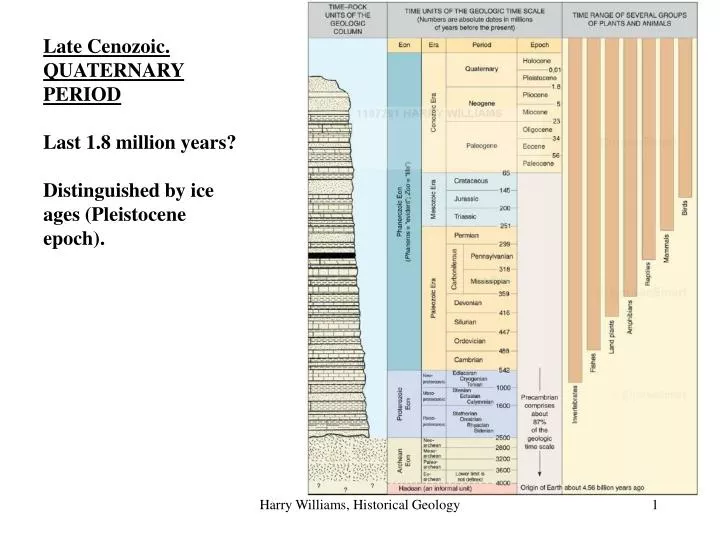
Late Cenozoic. QUATERNARY PERIOD Last 1.8 million years? Distinguished by ice ages (Pleistocene epoch).

E N D
Late Cenozoic. QUATERNARY PERIOD Last 1.8 million years? Distinguished by ice ages (Pleistocene epoch). Harry Williams, Historical Geology
Like astronomers battling over the status of Pluto, geoscientists are revving up to settle the fate of the interval of time known as the Quaternary, as well as the status, some feel, of an entire field. The dinosaurs had their Cretaceous period and the reptiles their Jurassic, but for 200 years now, humans have not agreed on what period of geologic time we are living in. It could be the Neogene period. On many geologic time scale charts, the Neogene runs from 23 million years ago to the present. Or it could be the Quaternary. “The Quaternary is the most important interval of geologic history,” says John Clague, former president of the International Union for Quaternary Research (INQUA). On some charts, the Quaternary spans the last couple of million years of time, including when humans took up tools and the world began slipping into icy climatic gyrations. Depending on the time scale considered, the Quaternary sometimes takes a position of pride following the Neogene period. But other times it's relegated to sideshow status, and sometimes it's even absent entirely. Indeed, in recent years, the International Commission on Stratigraphy (ICS) “abolished” the Quaternary, according to riled quaternarists. “They tried to suppress it while no one was looking,” says Philip Gibbard of the University of Cambridge in the U.K. “They nearly got away with it, [but] we were not going to have it.” The Quaternary “is a manifestation of our community,” adds Clague. “We don't want anyone denigrating that.” Harry Williams, Historical Geology
QUATERNARY (Note: it looks like the Quaternary will remain a period). The Quaternary Period is divided into 2 epochs - the Pleistocene (1.8 mybp - 10,000 ybp) and the Holocene (10,000 ybp - present). The Pleistocene was a time of fluctuating colder climates that resulted in a number of extensive glaciations or ICE AGES. Harry Williams, Historical Geology
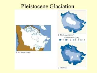
At present, ice covers about 10% of the land surface, whereas at its maximum extent during the Pleistocene it covered about 30%. Ice cover in the northern hemisphere about 15,000 years ago. Harry Williams, Historical Geology
Pleistocene glaciation is important since many areas glaciated in the Pleistocene are still dominated by glacial landforms today, even 10,000 years after the last Ice Age ended. The reason for this is that glaciers are capable of massive erosion and deposition and leave a long-lasting imprint on the local geomorphology. If you visit the northern states, or other glaciated regions, the only way to understand the local landscape is to recognize that these are glacial landscapes. So, the significance of the Quaternary period is not a record of bedrock formed during the period (as is the case for all the other periods we’ve looked at), it’s the geomorphology (surface landforms) that developed during the Quaternary, particularly glacial landforms. Harry Williams, Historical Geology
In North America, two distinct types of glaciation occurred: ALPINE GLACIATION, characterized by valley glaciers, in mountainous areas of the western U.S.; and CONTINENTAL GLACIATION, characterized by large unconfined ice sheets, over much of Canada and the northern states. ALPINE GLACIATION CONTINENTAL GLACIATION Harry Williams, Historical Geology
Landforms of Alpine Glaciation EROSION is the dominant process in glaciated mountainous regions. The glaciers are confined to pre-existing steep valleys and tend to erode vertically. Wide U-shaped glacial troughs, hanging valleys, horns, cirques, aretes and truncated spurs are the result. Harry Williams, Historical Geology
hills mountains cliffs ridges Harry Williams, Historical Geology
Examples from North America. Cirque, Labrador, Canada. Harry Williams, Historical Geology
Tarn - lake formed in the bottom of a cirque. Harry Williams, Historical Geology
Hanging valleys. Harry Williams, Historical Geology
H H C A A C Horns (H) , aretes (A), cirques (C). Harry Williams, Historical Geology
Glacial trough, hanging valley. Harry Williams, Historical Geology
Fjord - a submerged glacial trough - common on the coast of B.C., Alaska. Harry Williams, Historical Geology
Landforms of Continental Glaciation. Extent of glacial deposits from Pleistocene glaciations in the northern midwest. The last large glaciation was the Wisconsin. The Illinoian is an older glaciation that extended further south. Harry Williams, Historical Geology
DEPOSITION is dominant in lowland areas at the margins of continental glaciers - the northern states in North America. This is where debris carried in the ice is released as the ice melts. Further back from the ice front, (mainly in Canada) erosion can occur by SCOURING of the surface by debris (rocks) carried at the base of the ice. General scouring of the surface removed much topsoil from these areas, which is slow to recover due to the cold climates. Scouring also creates small grooves or striations or lager troughs aligned with the direction of ice flow; many larger troughs filled with water to become lakes. Harry Williams, Historical Geology
Canada Shield lakes. Harry Williams, Historical Geology
Glacial striations. Harry Williams, Historical Geology
Much of the landscape of the northern mid-west is dominated by depositional landforms. Deposition can occur directly from the ice - erratics, ground moraine, drumlins, end moraines - or from meltwater (mainly gravel, sand, mud) in the form of lake deposits, outwash (melt-water stream) deposits and eskers (sub-glacial melt-water deposits). Harry Williams, Historical Geology
Ice-marginal areas Harry Williams, Historical Geology
Bouldery ground moraine, Canada. This debris is “plastered” onto the surface directly under the ice. Harry Williams, Historical Geology
Areas of ground moraine usually are not great for farming (boulders, water-logging, hummocky). They can be used for dairy farming e.g. Wisconsin. Harry Williams, Historical Geology
Erratics are common in ground moraine regions (this one is in Manitoba above the tree line). Erratics provide a clue to the source of ice. Harry Williams, Historical Geology
Ice flow Drumlin, Alberta. Drumlins are formed from moraine that is pushed up into a hill by over-riding ice and then “streamlined” by the ice flow. They “point” in the direction of former ice flow. Harry Williams, Historical Geology
Drumlins, Manitoba. Harry Williams, Historical Geology
End moraine forming on Baffin Island. Debris carried by the ice piles up at the front of the ice sheet (where melting occurs). Harry Williams, Historical Geology
Road cut through end moraine, Quebec. Moraines are always mixtures of different sized sediment. Harry Williams, Historical Geology
Esker - Manitoba. These are meltwater deposits laid down in a tunnel under the ice. The sediment is usually well-sorted sand and gravel. Harry Williams, Historical Geology
Esker, Quebec. Harry Williams, Historical Geology
Outwash is sand and gravel deposited by meltwater streams that form in the summer. These streams are typically braided and create wide outwash plains. Outwash can extend 10’s of miles beyond the margin of an ice sheet. Outwash sediment has the character of alluvium (well-sorted, stratified). Harry Williams, Historical Geology
Bedrock ridge Outwash plain Outwash plains are great for farming. They are flat, well-drained and fertile. This one is in Quebec. Harry Williams, Historical Geology
Summary: glaciers and ice sheets cause massive erosion and deposition. They create long-lasting erosional and depositional landforms. Glacial features dominate landscapes in the northern states and Canada, even though they were formed more than 10,000 years ago. In mountainous regions, glaciers are confined to valleys, concentrating their erosion. Consequently, EROSIONAL landforms dominate - there is relatively little deposition and few depositional features. In lowland regions, large unconfined ice sheets cause general scouring of the surface, while DEPOSITIONAL features dominate marginal areas (near the ice front). Deposition can be directly from the ice (ice-contact deposits, including ground moraine, drumlins, end moraine and eskers) or can be meltwater deposits (outwash plains) extending beyond the ice limits. Harry Williams, Historical Geology