Download
1 / 21
210 likes | 217 Views
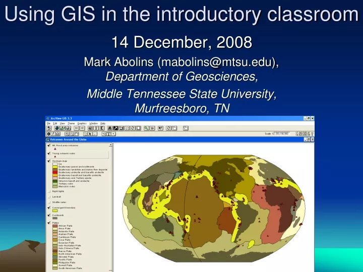
Using GIS in the introductory classroom. 14 December, 2008 Mark Abolins (mabolins@mtsu.edu), Department of Geosciences, Middle Tennessee State University, Murfreesboro, TN. Organization. Background Long Term Goals Science and GIS Unlocking Analysis and Research Opportunities (SAGUARO)

E N D
Using GIS in the introductory classroom 14 December, 2008 Mark Abolins (mabolins@mtsu.edu), Department of Geosciences, Middle Tennessee State University, Murfreesboro, TN
Organization • Background • Long Term Goals • Science and GIS Unlocking Analysis and Research Opportunities (SAGUARO) • Activities (2005-present) • Asteroid impact • Volcano • Evaluation • Future work
Background – 1Students • Geographic Information System (GIS) = Database + Quantitative analysis + Visualization • GIS-based activity for introductory non-majors Earth Science course • Students at regional comprehensive public university • No prior GIS experience assumed • Students use GIS to explore Earth Science
Background – 2Institution • Department includes both geology and geography • No graduate program • Departmental GIS courses serve undergraduate and graduate students studying numerous disciplines • Natural sciences • Social sciences • Education (e.g., outdoor recreation) • Humanities
Background – 3Facilities • 20+ seat departmental GIS lab • 24/7 GIS-equipped university computer lab
Background – 3Facilities • NSF-supported analytical equipment Warner Cribb, Ph.D., MTSU Geosciences • X-ray fluorescence spectrometer (XRF) • Inductively-coupled plasma mass spectrometer (ICP-MS) • Geochemical sampling at Mount Hood, Oregon • After graduation, some undergraduates complete petrology/volcanology masters theses • e.g., one student currently working with Jim Walker at Northern Illinois
Background – 4Funding for GIS Curricula • ~$20K from NASA Earth Observing System Higher Education Alliance (“GeoBrain”) • Small grants from Tennessee Space Grant • NSF STEP
Long Term Goals • Knowledge • All students can describe a GIS in general terms • Recruitment • Some students • enroll in GIS course • declare a major in Geoscience
Science and GIS Unlocking Analysis and Research Opportunities (SAGUARO) • GIS for non-majors introductory Earth Science • Subject matter • Plate tectonics - Water cycle • Oceanography - Tropical cyclones • Software • Arcview 3.x - ArcGIS 9.x • Developed by Michelle Hall-Wallace (Science Education Solutions), C. Scott Walker (Harvard), and others • Curricula developed 1998-present • Initially a large NSF grant
Activities • Asteroid impact • Volcanoes • Geochem. data • GEOROC • NAVDAT • Geospatial data • “GeoBrain”
Evaluation • Aimed primarily at justifying/defending use of GIS in introductory Earth Science • Time required for completion • Student perceptions • Difficulty • “Uninterestingness” • Student opinions about future use • Re-use? • More GIS anyone? • To GIS or not to GIS, that is the question. • N=42 (45% of class completed survey)
H O U R S ACTIVITY
MORE DIFFICULT S C A L E O F 1 T O 5 LESS DIFFICULT ACTIVITY
NOT INTERESTING S C A L E O F 1 T O 5 INTERESTING ACTIVITY
NOT INTERESTING S C A L E O F 1 T O 5 INTERESTING ACTIVITY
Re-use? Modify? • Students support re-use of both activities.
* Students prefer GIS to other homework * Students like the amount of GIS-based instruction In general, you would like to see _________GIS-based instruction in the course. Suppose you have to spend 1 hour working on a homework assignment. How would you rather spend this time?
Sample strengths • The directions are easy to follow. • Allowing students to visualize what is being studied. • "Hands on " participation. • It is interactive and user friendly (if you have the directions!) • Interactivity, working with real data. • The computer! I love the computer.
Sample weaknesses • Can be somewhat difficult to operate program. (For those who are computer illiterate.) • Not enough hands on stuff. • Boring, tedious. • Software available on campus in only 2 places. Difficult to install/complete at home. • The software is horrible. Granted it has to do a lot but I can’t imagine a worse interface.
Summary • Student perceptions of impact and volcano activities are broadly similar to perceptions of SAGUARO curricula • 30 min to 1 hour for activity completion • similar perceptions of difficulty and “interestingness” • Students support future use of GIS • Re-use of impact and volcano activities • Prefer GIS to other homework