Download
1 / 10
100 likes | 209 Views
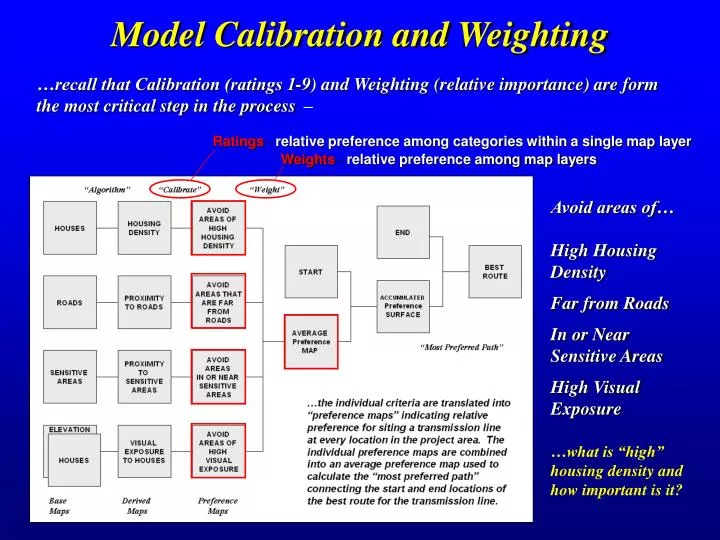
Ratings – relative preference among categories within a single map layer. Weights – relative preference among map layers. Model Calibration and Weighting. …recall that Calibration (ratings 1-9) and Weighting (relative importance) are form the most critical step in the process.

E N D
Ratings– relative preference among categories within a single map layer Weights– relative preference among map layers Model Calibration and Weighting …recall that Calibration (ratings 1-9) and Weighting (relative importance) are form the most critical step in the process – so how can we objectively we determine them? Avoid areas of… High Housing Density Far from Roads In or Near Sensitive Areas High Visual Exposure …what is “high” housing density and how important is it?
1 for 0 to 5 houses …group consensus is that low housing density is most preferred Judgment Fact Calibrating Map Layers (Delphi) Model calibration refers to establishing a consistent scale from 1 (most preferred) to 9 (least preferred) for rating each map layer… The Delphi Process is used to achieve consensus among group participants. It is a structured method involving iterative use of anonymous questionnaires and controlled feedback with statistical aggregation of group response. (See www.innovativegis.com/basis, select Column Supplements, Beyond Mapping, September 03, Delphi)
Information on each data layer is presented and discussed by the group Each participant identifies their cut-off values 1=good to 9= bad (avoid) Summary statistics are computed and used to stimulate discussion about differences in opinions Delphi Process (Spreadsheet) …structured method involving iterative use of anonymous questionnaires and controlled feedback …the process is repeated until there is “acceptable” consensus on the calibration ratings
…group consensus is that housing density is very important (10.38 times more important than sensitive areas) HD * 10.38 R * 3.23 SA * 1.00 VE * 10.64 Weighting Map Layers (AHP) Model weighting establishes the relative importance among map layers (model criteria) on a multiplicative scale… The Analytical Hierarchy Process (AHP) establishes relative importance among map layers by mathematically summarizing paired comparisons of each layers’ importance (See www.innovativegis.com/basis, select Column Supplements, Beyond Mapping, September 03, AHP)
Each participant completes questions comparing the relative importance of two data layers-- “…avoiding locations of high visual exposure is _____ more important than avoiding areas close to sensitive areas” 1=same to 9= extremely more important Responses are entered into the pairwise comparison matrix and it is solved for the relative weight of each map layer Calculating the Relative Weights (Expert Systems) …establishes relative importance among by mathematically summarizing paired comparisons of map layers’ importance …statistics for logical consistency and degree of agreement are used to determine consensus (repeat as necessary)
Avoidance Areas Buildings + Buffer Special Places Sensitive Areas Physical Barriers Can’t go there… Combined Avoidance Areas Group Perspective Engineering Requirements Linear Infrastructure (48%) Slope (9%) Intensive Ag (43%) Avoid if possible… Discrete Preference Surface (Step 1) (1) Layers Wt. Average Engineering Natural Environment Wt. Average CRITERIA Floodplain (6%) Streams/Wetlands (21%) Public Lands (16%) Land Cover (21%) T&E Species Habitat (36%) (1) Wt. Average Natural Built Environment Proximity Buildings (12%) NRHP Historic (14%) Building Density (37%) Proposed Development (6%) Spannable Waterbodies (4%) Land Use (19%) (1) Wt. Average Built Masking Calibration Layer Weighting Group Weighting Real World Application (Processing Schematic) Alternative Corridor Model Avoided Areas Routing Criteria: Engineering Natural Built Overall Preference Surface
E=1 N=1 B=5 E=5 N=1 B=1 E=1 N=5 B=1 E=1 N=1 B=1 Weighting one stakeholder group over the othersderives Alternative Corridors that emphasize stakeholder particular concerns Identifying the Routing Decision Space Combining alternative corridors identifies the decision space reflecting various perspectives …the routing decision space is identified by combining the Alternative Corridors GeoWorld magazine feature article on the EPRI_GTC projecthttp://www.geoplace.com/gw/2004/0404/0404pwr.asp
Acquire Additional Detailed Field Data The Siting Team collects additional very detailed field data within the decision space defined by the Alternative Corridors
…based on the detailed field data, the Siting Team investigates the impacts of the Alternative Routes Investigating the Alternative Routes (GIS-derived ) • Standardized Alternative Routes • Built • Natural • Engineering • Simple “Simple” Discrete Preference Surface shown as background … avoid areas in warmer tones (red) and favor locating in cooler tones (green) Built-up Area (avoid) Less Suitable Open Field (favor) More Suitable Note: if the additional detailed data warrants, the Siting Team can re-locate portions of the GIS-derived Alternative Routes but a formal statement of the reasons are required; alignment of a potential route outside of the decision space requires an exception petition (analogous to land use re-zoning)
GIS-derived Scores Expert Judgment Evaluating Potential Routes (selecting the Preferred) …the relative merits of top few potential routes are discussed by the Siting Team and then ranked to identify the most preferred route