Download
1 / 36
360 likes | 494 Views
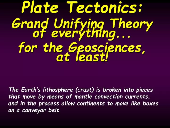
Plate Tectonics: Grand Unifying Theory of everything... for the Geosciences, at least!. The Earth’s lithosphere (crust) is broken into pieces that move by means of mantle convection currents, and in the process allow continents to move like boxes on a conveyor belt.

E N D
Plate Tectonics: Grand Unifying Theory of everything... for the Geosciences, at least! The Earth’s lithosphere (crust) is broken into pieces that move by means of mantle convection currents, and in the process allow continents to move like boxes on a conveyor belt
Plate tectonics theory says that the Earth’s core is broken up into pieces that move by plowing through the other rocks on Earth’s surface? • True • False
Introduction • Plate Tectonics Theory > explains location of and actions associated with.... - Volcanoes (distribution and composition) - Earthquakes (distribution, strength, depth) - Mountain Ranges (of all types) - Natural resources (distribution and formation of Coal, Mineral Resources, & Oil) - Ocean basins ( age, shape, and size) biologic - distribution and behavior + (fossils and modern animals) - seemingly incompatible climate records A theory that unified the geosciences by explaining nearlyall geological phenomena
Plate Tectonics and Continental drift are NOT the same thing! • Continental drift was the hypothesis postulated by Alfred Wegener that was rejected due to the wrong explanation for how the continents were moving • Plate tectonics built upon Wegener’s rejected hypothesis and added a lot of new information including... • Sea floor spreading • Paleomagnetism • Age of sea floor along oceanic ridges
Plate Boundaries, Earthquakes and Volcanoes • Red boxes show the location of the next three slides
A small shield volcano in Iceland • thin lava is created at a DIVERGENT PLATE BOUNDARY • The low viscosity lava creates the shield volcano
Confirmation of Sea-Floor Spreading Confirmation of Sea-Floor Spreading • Deep sea drilling supports the hypothesis that ocean crust is forming at the ridges and moving away from the ridges.
Mt Rainier in Washington State- a classic example of a stratovolcano • The lava associated with this type of volcano is created as oceanic crust melts and pushes through continental crust along Convergent subduction plate boundaries
A couple of cinder cones and a lava flow in New Mexico • This type of volcanic cone is often found associated with other volcanoes, and commonly where plates have been completely subducted and the melted material is in its last gasps.
Alfred Wegener, Continental Drift Hypothesis • 1912-1915: Alfred Wegener proposed a hypothesis called "continental drift". > Continents were once together Supercontinent; Pangaea = all, Gaea = land). (Pan > His ideas would become the foundation for Plate tectonics once additional data were collected! • Based on a lot of geological evidence > mountain ranges, fossils, continental fit, & similar rocks • Wegener's theory lacked a scientifically valid explanation for how the continents could move. - Hypothesis was rejected for the above reason An alternative model, “Contracting Earth”, was instead favored by many geoscientists at the time in spite of it’s many shortcomings
Continental Fit • 1965: Edward Bullard proposed modification of Wegener’s idea of fitting continents by using the 2,000 m isobath, which corresponds to the continental slope and the edge of continental crust.
Similarity of Rock Sequences • Identical Carboniferous rocks on Gondwana is tough to explain if the continents were not joined at that time
• Various mountain ranges are currently widespread. Rejoining separated continents shows the linear nature of the mountain chains.
Tropical locations have geological evidence of Carboniferous glaciation. • The former parts of Gondwanaland are today widely separated.
The Gondwana Ice Cap The Gondwana Ice Cap • If the continents are reassembled, the glacial evidence makes sense. • At the same time most of Laurasia was in the tropics.
Gondwanaland Animal and Plant Fossils Gondwanaland Animal and Plant Fossils
Sea-Floor Spreading • Sea floor mapped during the 1950s - revealed the ocean ridge system. • Magnetic reversals recorded in the rocks > symmetrical with respect to the ridge axis. • 1962: Harry Hess > proposed sea-floor spreading to account for continental movement.
Magnetic Data and the Ridge Axis Magnetic Data and the Ridge Axis • proof for sea floor spreading and a mechanism to move plates
Age of the Ocean Basins Age of the Ocean Basins
Which is not something that was used to support Continental drift hypothesis? • The fit of the continents • The alignment of mountains • The locations of fossils on various continents • The arrangement of unique rocks on continents • All of the above were used to support Continental Drift hypothesis
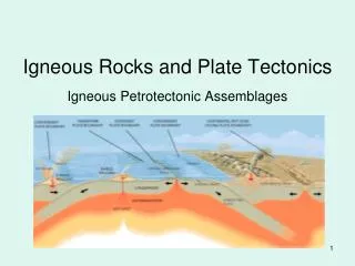
Plate Boundaries • Convergent : where two plates meet, with one being subducted or > both being forced upward . > • Divergent : where two plates spread apart at a ridge or rift. • Transform : where two plates or plate segments slide past each other. driven by convection cells within the mantle, the plates interact with each other
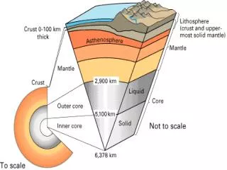
Earthquakes allow us to determine what the internal structure of Earth looks like- concentric spheres of material, each layer with specific characteristics that influence seismic wave movement
3D maps of the earth’s convection currents based on seismic wave analysis-complicated, but likely more realistic!
Himalayas Himalayas Tibet Tibet Indian Indian Plateau Plateau subcontinent subcontinent
Island Arc N Sea of Japan To RoC Pacific Ocean
Which type of plate boundary is not commonly associated with volcanoes? • Continent-Oceanic convergent subduction • Divergent • Transform