Download
1 / 9
90 likes | 301 Views
National Weather Service Weather Forecast Office Mobile / Pensacola. 5 Day Weather Outlook Briefing Deepwater Horizon Event Decision Support. 2 PM CDT Thursday 6 May 2010. National Weather Service. Current Weather Pattern Thursday 6 May, 2010.

E N D
National Weather ServiceWeather Forecast Office Mobile / Pensacola 5 Day Weather Outlook Briefing Deepwater Horizon Event Decision Support 2 PM CDT Thursday 6 May 2010 National Weather Service
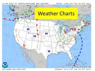
Current Weather PatternThursday 6 May, 2010 • High pressure is centered over the region, with a light wind flow pattern being observed. • Observation stations indicating variable winds offshore are light averaging 5 knots with southerly winds near shore around 10 knots (with a developing sea-breeze). • Offshore buoy data indicates seas are averaging 1 to 2 feet. • Drier air-mass associated with high pressure along the mid-Atlantic states is maintaining a dry pattern across coastal Mississippi, Southwest Alabama, and the western Florida Panhandle.
Thursday 6 May 2010 High pressure dominates the northern Gulf, resulting in mostly sunny skies with light and variable winds becoming south around 10 mph near the coast in the afternoon.
Forecast for Tonight6-7 May 2010 • South to southwest winds 10 knots. • Seas 1 to 2 feet. Smooth on the bays. • Chance of showers and thunderstorms less than 10 percent.
Forecast for Friday7 May 2010 • Southwest winds 10 to 15 knots. • Seas around 3 feet (wind waves). A light to moderate chop on the bays. • Chance of showers and thunderstorms 20 percent late in the day.
Forecast for Friday Night7-8 May 2010 • Southwest winds 10 to 15 knots. • Seas around 3 feet (wind waves). A moderate chop on the bays. • Chance of showers and thunderstorms 20 percent.
Forecast for Saturday8 May 2010 • Cold front moves southeastward across the coastal waters of MS, AL, NWFL Saturday morning. • Isolated showers and thunderstorms will form along the front. • Southwest winds 10 to 15 knots becoming northwest around 15 knots with the frontal passage. • Seas 3 to 4 feet (wind waves). Choppy on the bays. • Chance of showers and thunderstorms 20 percent.
Outlook9-10 May 2010 • Cold front will move south deeper into the Gulf Sunday with a northerly offshore wind becoming onshore again by early next week. • Sunday • NE winds 10-15 knots becoming SE 10 knots. • Seas around 3 feet. A light to moderate chop on the bays. • Monday • SE winds 10 to 15 knots. • Seas 3 feet. A light chop on the bays.