Download
1 / 116
1.2k likes | 1.39k Views
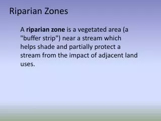
Riparian Ecosystems. By: David Gridley. General Overview. Riparian comes from the Latin word “ripa”, which means stream bank. A Riparian Ecosystem is a transitional system between aquatic and terrestrial ecosystems.

E N D
Riparian Ecosystems By: David Gridley
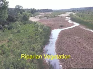
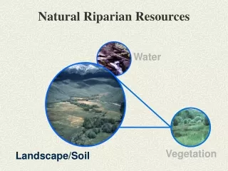
General Overview • Riparian comes from the Latin word “ripa”, which means stream bank. • A Riparian Ecosystem is a transitional system between aquatic and terrestrial ecosystems. • These are either freshwater or marine and can lie near lakes, streams, pond, rivers, oceans or any body of water.
Zonation: • Riparian systems are zoned just as many other types of ecosystems. • Sedges and rush live on the banks at or above water level. These can frequently become submerged depending on what aquatic system is present. • Shrubs live above the sedges and rush. • Deciduous trees live above the bank and provide shade during the midday sun and a home for various species. • The trees are the last plant species characterized in a Riparian system. The Upland system follows.
Soil types: • There are a variety of soil types found in a Riparian system. Common soils are those which are found in wetlands (silts and clays). • Sands and gravels are also common. These are highly porous which allow for water movement. • Porosity allows for variability in the types of plants in the system. • Zonation occurs in a small distance laterally. There is no general width to the system. It depends on the hydrology of the aquatic system.
Habitat: • This is a very diverse ecosystem. • These areas are very rich in life. They are home to various animals and plant. • Small mammals are able to nest on the banks underneath the vegetation while birds are able to nest in the vegetation. • The various plant species create a food source as well as shelter for insects, birds, mammals, and even fish in the water.
Vegetation: • Vegetation provides cover and a natural habitat for species.
Uses: • The plants that live in these systems help to clean the water. • Stem densities near the shore can slow the water movement enough for suspended solids to settle out. • The roots also bring in nutrients and metals from the water which help to improve the water quality.
Benefits: • Natural undeveloped vegetated flood plain allow excess water to spread out and easily re-enter the channel or to be soaked up by the wetland soil. • The vegetation provides various barriers against the flowing water. • The natural ecosystem is beneficial for wildlife and they are aesthetically pleasing.
Human Influence: • One problem is that humans tend to straighten and bend waterways at angles. This disrupts currents and creates areas of high erosion. • Irrigation ditches are easily flooded because they are not able to handle excess water. High rains can cause them to flood creating more problems. • Straight channels reduces surface area of banks and therefore reduces the amount of habitat available for animals. This in turn creates competition for space and food.
Human Influence: • When buildings and unnatural structures are placed in a floodplain and near waterways reduce the ability of the soil to absorb the water. • Buildings also impede the movement of the water and will be damaged by the excess water.
Problems • Straightening or Channelizing waterways has turned them into a mechanical waterway instead of a healthy stream environment. • When streams are straightened and direction is changed from its natural state inundation becomes a problem.
Problems cont: • Acequias are found throughout the west because droughts are common in the area. Water divergence is a common practice which allows farmers to maintain crops through the dry season. • This diverts water from its original source direction and into new areas.
Acequia cont: • These are actually a man made irrigation ditches. • These bring water to areas that are normally dry and allow for vegetation to grow that would not normally have been there. • Erosion is a problem that frequently occurs
Restoration: • There are many restoration efforts underway that will return Riparian Ecosystems to there natural state. • One major problem with this effort is that diverting the water back to its original habitat will only create more problems just as the original divergence did. • The effort must take place where the water is presently routed.
Restoration: • Terraced and vegetated canal banks are now being used as a way to prevent inundation and erosion in events of high water. • Proper plant species such as oaks, willows, and cottonwoods are being used to create shade and help smaller plant species grow. • The trees will also out compete weeds to help create a healthy habitat for all life forms.
Restoration: • A portion of Bear Creek in Iowa. • This restoration took place in 4 years. It now has a healthy soil environment as well as a healthy habitat for the species that live here.
Another Success • Gila River at Kelvin, AZ. • Top picture is from 1945. • The bottom picture is from 2002. • The difference in habitat is quite clear.
Southern Deepwater Swamps Brian Simpson
Geographical extent Only found in freshwater environments not so much climate dependant as hydrology, generally found along rivers and streams in the Southeast Coastal Plain and along the Gulf Coastal Plain to southeastern Texas, and up the Mississippi River to southern Illinois. There a few areas with similar habitat and vegetation located in the northeast these are small in comparison.
Southern Deepwater SwampsGeneral overview Sometimes referred to as southern freshwater forested swamp. Freshwater systems with standing water throughout all or most of the year. They can be nutrient-rich in alluvial river swamps or under nutrient-poor conditions such as in rainwater fed swamps. Primary production is closely related to hydrologic conditions.
Geomorphology • Located in broad, flat floodplains or they can be in isolated basins. • Deepwater swamps are located in floodplains where there are meandering river channels, adjacent to natural levees, oxbow lakes, and sloughs which represent areas of ponded water. (Leopold et al, 1964) • Found in areas of very low relief, where slight changes in elevation (just a few cm) can produce quite different hydrologic conditions, soils, and plant communities. Brown 1972) • Biogeochemical processes are strongly linked to hydrologic characteristics. The depth and duration of flooding, as well as whether the flood waters are flowing or stagnant, affect whether the wetlands serve as sinks, sources, or transformers of nutrients..(Brinson 1990)
Cypress swamps as sinks, possible transformers and sources • Sinks: reports of 50% reduction in P as overflow waters passed through a swamp. (Day et al) In some locations it has been found that they were effective as sinks for over 50 years runoff of partially treated wastewater. More effective however, at P that at N collection. • Transformers: total inputs and outputs of nutrients remain similar yet there are noted net increases in organic N and P and a decrease in inorganic N and P. Transformations from inorganic to organic forms can be important for secondary productivity downstream.(Mitsch 1993) • Sources: in situations where there is periodic outflow from the system deepwater swamps can act as a mechanism of nutrient conservation during dormant seasons and transferred to the system during the growing season.
Hydrologic conditions Hydrology is the most important feature of deepwater swamp environments. Inflows are dominated by runoff from uplands and overflow from flooding rivers. (Mitsch and Gosselink 1993) Outflows are limited by controlled by substrate, and the swamps distance from adjacent streams Topographic features may impound water and cause flooding from rainfall rather than from stream overflow. Water levels vary seasonally and annually, with high water levels coinciding with winter and spring rains and melting snow. In the summer low levels occur due to high evapotranspiration and low rainfall (Wharton and Brinson 1979)
pH and Nutrients • Wide range of acidity pH can vary from 3.5 in swamps fed by rainwater whereas the pH of many alluvial swamps can be 6 to 7. • Cypress domes and dwarf cypress swamps are low in nutrients because of their hydrologic isolation. Sampling of (P) showed concentration of 50 to 160 µg/l • Alluvial river swamps and lake edge swamps tend to have much greater input of nutrients. Sampling of (P) showed concentrations as high as 660µg/l(Mitsch et al.1977)
Sedimentation/ Primary Production Sediment deposition occurs during flooding conditions The rate of sedimentation can control the rate of succession. A high rate of sedimentation is associated with occurrence of cypress and tupelo stands which grow to be 200-300 years of age (Hodges 1994). Primary productivity seems to be greater in the mixed hardwood swamp environment. These swamps tend to have seasonal flooding rather than constant flooding or constantly drained.
Productivity vs. Flooding The highest productivity occurs periodic/seasonal flooding situations, low productivity is characteristic in continuously flooded or drained.
Typical Vegetation Canopy vegetation: • Well adapted to a wet environment. Includes bald cypress, pond cypress, tupelo, red bay and various hardwoods. Spanish moss typical in deep south. Understory vegetation: (difficult to generalize due to lots of other variables) • Dependant on light penetration through canopy. Woody shrubs, small trees, herbaceous veg., variations from nutrient rich to nutrient poor. Nutrient rich areas grow a mat cover.
Typical hardwoods in canopy, understory mat of duckweed, virginia willow.
Buttresses Swollen Buttress, Okeefenokee Swamp, GA Cypress with watermarks, Brunswick Co., NC. Good indicators of hydroperiod. Greatest swelling appears to be where there is continual wetting and soaking of the tree trunk. The actual function is unknown and thought to be a relic response.
Cypress Knees Extend from trunks to well above water level. Still unsure as to purpose. Thought to be anchors for the tree and/ or could be possible areas of gas exchange for the root system. (Ewel and Penfound)
Five subclasses Each have similar characteristics , however vary slightly (Wharton et al 1976) 1.Still water cypress domes 2.Dwarf cypress swamps 3.Lake-edge swamps 4.Slow-flowing cypress strands 5.Alluvial river swamps
Cypress Domes Rainfall and surface inflow. Generally 1-10 hectares in size. Poorly drained to permanently wet, where they form dense cypress heads, composed almost entirely of cypress; within these heads, growth conditions are better towards the center. Sandy and clay soils, the cypress heads form a very distinctive dome shape and are called cypress domes, with progressively taller tress toward the center, attributed to greater peat accumulation.
Dwarf cypress swamps Pond cypress is the dominant tree but grows stunted and scattered throughout the freshwater marshes. These trees rarely grow over 7 m high and average only 3 m in height. The poor growing conditions, which are defined here as lack of significant substrate above the limestone, prevent larger trees from establishing themselves in this environment. Fires often occur here but usually do not kill the cypress due to the lack of combustible organic material accumulation.
Slow-flowing Cypress Strands Diffuse freshwater stream flowing through a shallow forested depression on a gentle sloping plain (Wharton 1976). Substrate is primarily sand with a mixture of limestone and shell beds. Shallow peat layer. They have a seasonal hydroperiod(wet and dry cycle. Corkscrew Swamp, Fl
Lake edge swamps Generally bald cypress swamps found along lake margins in the Southeast. Also have tupelo and other water tolerant hardwoods. Seasonal fluctuations in water level. Nutrient rich due to runoff from lake and uplands. Also can act as filters that receive overland flow from the uplands and allows sediments to settle and chemicals to absorb into the sediments before discharge into the open lake .
Alluvial River swamps Found in floodplains of river and creeks of the southeast. Dominated by bald cypress and/ or water tupelo. Confined to permanently flooded depressions. Abandoned river channels(oxbows) or elongated swamps that usually parallel the river(sloughs). Sometimes referred to as backswamps. Nutrient rich because of river flooding and upland runoff.
Economic resources and environmental impacts Cypress was a staple commodity during the 1600-1700’s for new settlers of the south. These areas were logged extensively. Many deepwater swamps were lost due to clearcutting. Production increased from 495 million board feet 1899 to 1 billion board feet in1913. By 1925 stocks were running low, they had essentially cut all the old growth cypress and second generation cypress was not as well suited. It is still a valuable resource just not as widely marketed.
Hydrology models S.L. Brown developed a hydrology model depicting how drainage of the Green Swamp wetlands led to lower aquifers, drier streams, and greater flooding. Other models by Littlejohn and Weimoff have demonstrated storage capacities and groundwater protection capabilities of these areas.
Further research efforts Studies should be done to improve long term predictive capabilities and knowledge of the fine structure of these systems in order to incorporate proper planning and management practices. Particularly in the area of hydrological function and any factors contributing to loss.
Defining pocosins Geographic extent Soils Hydrology Vegetation Low vs. high pocosin communities Fauna Succession Response to fire Development Management Topics
Definitions • Fresh water wetlands. • Algonquin word poquosin, roughly = “swamp-on-a- hill”. • Early European settlers used the term to describe a variety of swampy or marshy land consisting of poorly drained, peaty soils supporting pond pines and evergreen shrubs. • The Oxford English Dictionary defines a pocosin as a track of low swampy ground usually wooded in the southern united states.
Defintions Cont’d • In 1875 W.C. kerr, the state geologist of NC in a geologic Survey of North Carolina, defined pocosins as “flatwoods with no natural drainage ways, different from swamps in that they are not alluvial, occurring on divides between rivers and sounds and frequently elevated above streams of which they are the source”.
Defintions Cont’d • In 1928 Wells provided a more broad definition. According to Wells the defining factors of a pocosin include soil type, hydrology, topography, occurrence of periodic burning, and vegetation.
Wells described pocosins as wetlands occurring in broad shallow stream basins, drainage basin heads or broad flat upland areas of the coastal plains that are characterized by long hydroperiods, temporary surface water, periodic burning, and soils of sandy humus, muck, and peat. The dominant vegetation being broad leaved evergreen shrubs or low trees. • Later defining of the term by other authors, generally followed this concept pocosins.
According to the U.S. fish and Wildlife wetland classification system pocosins are classified as follows: • System: Palustrine • Class: Scrub-shrub • Sub-class: Broadleaved evergreen. • Water regime: Saturated. • Water chemistry: Fresh-acid • Soil: Medisaprist
Geographic Extent • Occur on the southeastern coastal plain spanning from Virginia to southern Florida. • North Carolina possesses seventy percent of all pocosins. • In 1962 there were approximately 2,243,550 acres of pocosins in NC.