Download
1 / 45
450 likes | 533 Views
2011 Seasonal Prediction for Canada. Kerry Anderson. Methodology. Calculate spring start-up conditions based on fall drought code (DC) values and over-winter precipitation amounts, Calculate average daily weather for weather stations across country,

E N D
2011 Seasonal Prediction for Canada Kerry Anderson
Methodology • Calculate spring start-up conditions based on fall drought code (DC) values and over-winter precipitation amounts, • Calculate average daily weather for weather stations across country, • Incorporate Environment Canada’s seasonal predictions, • Determine the fire severity based on the ratio of forecasted over average seasonal severity rating (SSR).
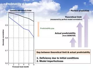
Ensemble Forecasts Recently, the Canadian Meteorological Centre (CMC) of Environment Canada has begun providing temperature and precipitation probabilistic forecasts based on an ensemble of ten integrations of four independent models: climate ver. of the Global Environmental Multiscale model (GEM-CLIM), 2nd gen. of the Atmospheric General Circulation Model (AGCM2), 3rd gen. of the Atmospheric General Circulation Model (AGCM3), Spectral aux éléments finis (SEF). Forecasts are provided for the next four months.
Ensemble Forecasts The ensemble approach provides a measure of confidence indicated by the spread of the ensemble members. The extended forecast continues to use the single, deterministic forecast
2006 Prediction Using hotspots to assess the seasonal outlook, the forecast was good for Southern BC, the Northern Prairies and western Quebec. On the other hand, the forecast was marginal for the Southern Yukon and central Alberta and poor for central Ontario, central Quebec and Labrador.
2006 Prediction Comparing the distribution of the forecasted over average SSR values for all of Canada (area within each prediction value) and for hotspot locations shows that the seasonal forecast had skill at predicting fires for most of Canada.
2007 Prediction The 2007 prediction showed below-average conditions throughout much of Canada. Only Vancouver Island, central Saskatchewan and northern Manitoba show above-average severity.
2007 Prediction As it turned out, 2007 was a quiet fire season with fire activity limited to Quebec, Southeastern BC, and the northern boreal plains.
2008 Prediction May June July August For 2008, monthly predictions indicated an above-average year for most of Canada.
2008 Prediction 2008 turned out to be a quiet fire seasons with only 1.49 million ha burned (10 year average is 7 million ha). July Most of the fire activity (95%) occurred in Saskatchewan and NWT (mainly in July) suggesting that while we over-predicted the severity of the fire season, we correctly predicted the region of peak fire activity.
2009 Prediction May June July August For 2009, monthly predictions indicated an above-average year for western Canada.
2009 Prediction Again, another quiet fire season for most of Canada with only 846 000 ha burned. 6,636 fires In August, an emergency situation developed in British Columbia burning over 229 000 ha (10 year average 75 000). 846,484 ha
2010 Prediction May June July August For 2010, monthly predictions indicated above-average spring conditions year in Quebec and an above-average summer for most of Canada.
2010 Prediction An above-average season with twice the average annual area burned. 7,319 fires (avg: 7,389) Most of the activity occurred in Quebec (May), Saskatchewan (July) and BC (August). 3,155,099 ha (avg 1,647,438 ha)
Spring Start-up Conditions • The Canadian Forest Fire Weather Index (FWI) System allows for the carry-over of fall conditions to the spring. • This is handled by the Drought Code (DC) (similar to the 1000 hour moisture code). • All other moisture codes in the FWI system are reset.
Fall Conditions Oct 31, 2010 Fall DC values show extreme (dry) conditions throughout much of Western Canada and the Territories.
Precipitation Trends Canada experienced a normal precipitation year in 2010, 0.4% above normal. The Prairies experienced its wettest year on record, 26.9% above normal. http://www.ec.gc.ca/adsc-cmda/
Temperature Trends The national average temperature for the year 2010 was 3.0°C above normal. 2010 was the warmest year on record since nationwide records began in 1948.
Spring Start-up Conditions Canadian Drought Monitor indicates a relatively normal pattern with parts of Alberta described as in severe drought
Spring Start-up Conditions Late spring prevents us from seeing the starting DC values, though it appears much of Canada has had nearly total recharge of deep fuel moistures.
Spring Start-up Conditions 2003 2004 2005 2006 2007 2008 2009 2010
Yukon Normal snowpack conditions throughout much of the Territory with above-average in the southwest and below-average in the central Yukon.
Yukon ENSO pattern indicates conditions similar to 1971, 1974 and 1999. This suggests warm conditions and high precipitation rates in central Yukon, pointing to an active lightning season.
Saskatchewan April 1st start-up DC indicates the Northwest may be an area of serious concern. Otherwise start-up values are low over the remaining regions. Green-up will probably occur early this spring even with a cooler spring regime.
Parks Canada The Climate Prediction Center (NOAA) on ENSO status continues to forecast La Nina weakening and going neutral by June. A similar pattern preceded the following fire seasons – 2008, 2001, 2000(?), 1996, 1989, 1976. The large fire database was considered for these years to predict what this year will bring. For recent persistence, maybe like 2008? Although with current conditions out west, not much will happen for a month or two.
International Research Institute for Climate and SocietyENSO Quick Look http://iri.columbia.edu/climate/ENSO/currentinfo/QuickLook.html
International Research Institute for Climate and SocietySummary of ENSO Model Forecasts http://iri.columbia.edu/climate/ENSO/currentinfo/SST_table.html
El Nino Effects Summer Temperature Precipitation El Nino leads to below-average precipitation in central Alberta and Saskatchewan, southern Ontario and Nova Scotia
Seasonal Forecasts Spring temperature anomalies are low for much of Canada. Precipitation anomalies are high for BC and eastern Canada and mixed for the west and north. April-May-June
Seasonal Forecasts Early summer sees above-normal temperatures in northern Canada and the Maritimes. Below-normal precipitation is predicted for the north and above-normal in Ontario and the Maritimes. May-June-July
Seasonal Forecasts Summer temperature anomalies are high for most of Canada. Below-normal precipitation is predicted for BC and the Hudson’s Bay region, while above-normal precipitation is predicted for the remaining portions of Canada. June-July-August
April 2010 Prediction (predicted values normalized against average weather) Confidence (standard deviation normalized against average weather) Low conditions in western Canada and southern Ontario. High confidence in all but the northwest.
May 2010 Prediction (predicted values normalized against average weather) Confidence (standard deviation normalized against average weather) Below average condition continue in much of Western Canada, while fire weather conditions remain average in Quebec.
June 2010 Prediction (predicted values normalized against average weather) Confidence (standard deviation normalized against average weather) The Yukon, NWT, northern Alberta and Quebec may see fire activity. Confidence in the forecast drops in central Canada.
July 2010 Prediction (predicted values normalized against average weather) Confidence (standard deviation normalized against average weather) July sees an significant increase in fire weather conditions in western and eastern Canada. Low confidence in predictions for central Canada.
August, September 2010 Predictions (predicted values normalized against average weather) Predictions show high fire weather in BC and central Canada. Confidence in these extended forecasts are low.
May-Aug 2011 Prediction (predicted values normalized against average weather) Confidence (standard deviation normalized against average weather) The 2011 fire season could be above-average for BC and Eastern Canada. Confidence in the above-average region in central Canada is low.