Download
1 / 16
170 likes | 280 Views
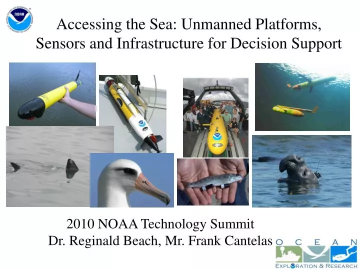
Accessing the Sea: Unmanned Platforms, Sensors and Infrastructure for Decision Support. 2010 NOAA Technology Summit Dr. Reginald Beach, Mr. Frank Cantelas. Some Benefits of Unmanned Systems.

E N D
Accessing the Sea: Unmanned Platforms, Sensors and Infrastructure for Decision Support 2010 NOAA Technology Summit Dr. Reginald Beach, Mr. Frank Cantelas
Some Benefits of Unmanned Systems • Unmanned Systems ability to increase the pace, scope and efficiency of accessing or monitoring the environment to support Decision Making • Complement ships and manned aircraft: • Potential for Longer Duration Observations • Can Reach Remote, Inaccessible or Dangerous Locations • Can Increase Data Quality over Traditional Methods • Affordable, Scalable, Common Standards • It’s a rolling boil on many fronts……. • Platforms, Sensors and Infrastructure
AUV Mapping of West Coast GroundfishTeam: NMFS NWFSC, OSU, & WHOI Mosaic Courtesy WHOI (H. Singh)
Synthetic Aperture Sonar SAS-12 (Bluefin AUV) Prudence Island Wreck Image Anchor Chain
CTD tags Elephant seals……looks like a Glider! 22 Temperature 0
CTD tags Elephant seals……looks like a Glider! 40 Conductivity 30
Benthic Ecosystem Assessment • Habitat Mapping • Fisheries Surveys • Deep Exploration • Maritime Archaeology NOAA Unmanned Systems Missions • Water Column Ecosystem Assessment • Fisheries Surveys • Regional and point source events (e.g., DWH) Hydrographic Survey/ Port Security • Oceanography • Ocean Circulation and Structure • Climate and Weather observations • Hurricane Forecasting
NOAA AUV Roadmap Identifies platforms and missions that unmanned systems (primarily gliders and propeller driven AUV’s) can fulfill. • Content: • Vision • Operating Principles • AUVs in NOAA Missions • Recommendations • Status • Approved by Research Council Aug 2009 • Under review by PA&E • Outlook? PPBES => $0 • => TF on Unmanned Systems
“Grassroots” Capability Demonstrations • 2005 Katrina Harbor Surveys (NOS) • 2008 AUVfest demonstration of dual-use capability of Navy MCM platforms formarine archaeology+ • 2009 First TransAtlantic Glider (IOOS) • Bonaire Coral Mapping (2008), NOS Marine Debris (2010), NMFS Scallop Survey (2011), Thunder Bay Sanctuary Expansion Survey (2010) • Animal Borne Sensors (TOPP, POST, Narwals, Applications for Climate, Arctic, IOOS, Weather)
New Platforms • Solar AUV, Long Endurance, Hybrid Surface / Sub Surface • ONR Fuel Cell AUV, 90 days, 20 kts sprint • NEREUS: Full Ocean Depth, Hybrid ROV / AUV), uses Ceramics • Unmanned Surface Vessel – Wave-Driven Locomotion, Long Endurance • NDSF Sentry – Photo Mosaic AUV • UK AutoSub - UnderIce AUV • ENDURANCE (Environmentally Non-Disturbing Under-ice Robotic ANtarctiC Explorer)
Sensors – Many Interagency Sponsors • R. Camilli - Mass Spectrometer used in DWH • O. Schofield – Glider Fluorescence Sensor for primary productivity measurements • EcoPuck (Optics for Ecosystem Observations) • Water Sampling – Physical Samples • Animal Borne Sensors: Acoustic Business Tags, Ocean Tracking Networks • Growing Number of Active and Passive Sonars for Mapping (MB, SSS, SAS, Forward-Look) and Detection
[Growing] Infrastructure • Asset Pools: NIUST, CIOERT, NSWC-PC • $55M, 5yr Navy Procurement of 150 Gliders, Glider Operation Center @ NAVOCEANO • $77M, 5yr Navy Procurement of AUV’s, for TAGS-60 Hydrographic Surveys • NSF Ocean Observing Initiative; 3 Fleets of AUVs and Gliders Operationally Supported • IOOS Regional Associations (Gliders) • JSOST-F&I Task Force on Unmanned Systems • NOAA TFUS, Meets every 2 months