Download
1 / 1
10 likes | 97 Views
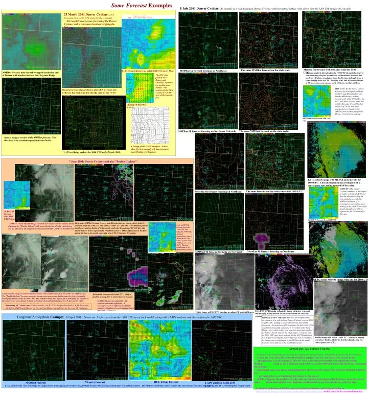
Some Forecast Examples. 5 July 2001 Denver Cyclone: An example of a well-developed Denver Cyclone, with forecasts of surface wind shown from the 1200 UTC run for all 3 models. 23 March 2001 Denver Cyclone: 24 h forecasts from 1800 UTC runs for the 3 models.

E N D
Some Forecast Examples 5 July 2001 Denver Cyclone: An example of a well-developed Denver Cyclone, with forecasts of surface wind shown from the 1200 UTC run for all 3 models. 23 March 2001 Denver Cyclone:24 h forecasts from 1800 UTC runs for the 3 models. All 3 models make a nice forecast of the Denver Cyclone, with a consensus location verifying the best. Mesoeta 3h forecast with obs, also valid for 1500 UTC. The same MM5hot forecast on the state scale. MM5hot 3h forecast focusing on Northeast Colorado. RUC 20-km 24h forecast valid 1800 UTC on 23 Mar. MM5hot forecast: note the well-wrapped circulation east of Denver, with another north of the Cheyenne Ridge. Ambient southerly flow develops by 1500 UTC (though the MM5 is slow at turning the flow around over southeastern Colorado), but no Denver Cyclone circulation forms by this time although there is some turning north of CYS. Both the MM5 and Mesoeta solutions at 3h show some convergence north of the two northern ridges. The RUC also predicts nice Denver and Cheyenne Cyclones, but nothing near Pueblo. The location of the DEN Cyclone is ~20 km west of the Mesoeta fcst. 1800 UTC:By this time a Denver Cyclone has developed, and both the RUC and Mesoeta show one, but the MM5hot has its best turning north of the CYS ridge; the RUC also has a cyclone there, but not the Mesoeta. It could be that the lack of S to SE flow over southeastern Colorado in the MM5hot forecast has prevented a Denver Cyclone from forming. Mesoeta forecast:also predicts a nice DEN Cyclone, but farther to the west, which is also the case for the "CYS Cyclone". Closeup of the RUC forecast RUC20 6h forecast from 1300 UTC run. The same MM5hot forecast on the state scale. MM5hot 6h forecast focusing on Northeast Colorado. Here is a bigger version of the MM5hot forecast. Note that there is no circulation predicted near Pueblo. Closeup of the LAPS analysis. A nice Den Cyclone is analyzed, but not much near Pueblo or Cheyenne. LAPS verifying analysis for 1800 UTC on 24 March 2001. 7 June 2001: Denver Cyclone and nice "Pueblo Cyclone". KFTG velocity image with METAR and other obs for 1800 UTC. A broad circulation has developed with a convergence zone setting up south of the radar. 2100 UTC: The Denver Cyclone continued to developed in reality, with the RUC20 and then the Mesoeta having the best simulations, while the MM5hot had more of a convergence zone with a lesser turning of the wind. None of the models though were able to capture the full circulation for this case. The same forecast on the state scale valid 1800 UTC.. MesoEta 6h forecast focusing on Northeast CO. 3h RUC-20 forecast valid 1600 UTC/7 June. RUC20 9h forecast from 1200 UTC run. State scale MM5hot forecast (above) and Mesoeta forecast (above-right), both 3h forecasts from the 1200 UTC run valid at 1500 UTC, with obs. The MM5hot forecast has the circulation displaced to the north, while the Mesoeta and RUC20 (far left) appear to have better captured the "Pueblo Cyclone". Other differences in the flow appear farther to the north, especially near CYS (Cheyenne, Wyoming). 1600 UTC visible satellite image centered over southeastern Colorado nicely depicting the "Pueblo Cylone" with a swirl in the low clouds. Also shown are the obs and a 4h surface wind forecast from the 1200 UTC MM5hot run. Left: 6h RUC20 forecast from the 1300 UTC run, valid for 1900 UTC. A strong convergence zone is shown in SE CO, with a cyclone near CYS but none near DEN. The best verification is for the Pueblo Cyclone. MesoEta 9h forecast focusing on Northeast Colorado. MM5hot 9h forecast focusing on Northeast CO. KFTG radar velocity image with obs for 2100 UTC. Visible satellite images overlaid with observations and wind forecasts from the 1200 UTC MM5hot run. The "Pueblo Cyclone" becomes more of a strong convergence zone that becomes the focus for rapidly developing thunderstorms by 1800 UTC. The MM5hot model does a good job in indicating the location of the convergence zone, though it failed to develop echoes along the feature (see 7h forecast far right). Mesoeta 6h forecast valid 1800 UTC. Only a gradual turning flow is shown in SE Colorado. MM5hot 9h forecast valid 1900 UTC overlaid with radar reflectivity. A convergence zone is still forecast, but the only forecast echoes are weak ones farther to the north. >>>>>>>> Summary of 7 June case: Varied results...the RUC20 did good on both 3 & 6h forecasts, while the MM5hot did better by 6h, and the Mesoeta was better at 3h, over SE Colorado. 2100 UTC KFTG radar reflectivity image with obs. A loop of this imagery nicely showed the circulation with the clear-air returns. Visible image at 2100 UTC showing tcu along CZ south of Denver. Longmont Anticyclone Example: 30 April 2001. Shown are 3 h forecasts from the 1800 UTC run of each model, along with a LAPS analysis and observations for 2100 UTC.. Summary of the 5 July case: This was an example of the development of a well-defined Denver Cyclone between 1500 to 2100 UTC, leading to a line of storms by later in the afternoon. No model was able to capture the full extent of the circulation (especially compared to the solutions for the 24 March case), which in this case was best developed north of the Palmer Divide and not the other ridges. Solutions from the 1800 UTC runs (not available for the RUC20) indicated that despite resolving the Denver Cyclone at the initial time, the feature was overwhelmed by the SE flow in the model forecasts, most quickly in the MM5hot forecasts. Visible image with obs at 2300 UTC. Anvils are already seen above the line of storms that developed along the convergence zone (CZ). SUMMARY and CONCLUSIONS --Overall it was encouraging to see that the models were often able to simulate both mesoscale flow features. --It was not clear, from this somewhat limited sample, that any one model was clearly better. --Though there is some indication that for cases where the flow feature was apparently rather shallow (such as the Longmont Anticyclone case) the MM5hot model did the best at resolving the feature. --Sometimes there was success simulating part of the case (for some of the features lifetime), but then the prevailing flow overhwhelmed the feature in the model. --While it appears the models can help with operational forecasting of the features, we need to learn more about when (under what ambient conditions) they are more likely to verify the best. A complete collection of all the cases saved and verification can be found online at http://laps.fsl.noaa.gov/szoke/mesoconf/cases_homepage.html, which can also be accessed from my homepage through the FSL homepage at http://laps.fsl.noaa.gov RUC 20 km forecast Mesoeta forecast MM5hot forecast LAPS analysis valid 2100 UTC LGM Anticyclone case summary: No single model does a great job on this case, perhaps because the turning easterly flow was rather shallow. The MM5hot probably comes closest; the Mesoeta doesn't have any turning, the RUC20 turning but too far south.