Download
1 / 1
10 likes | 60 Views
VolksWRF – A Weather Modeling Portal for the General Public. Don Morton 1 , Mike Jacobi 2 and Greg Newby 1 1 Arctic Region Supercomputing Center, University of Alaska Fairbanks, Fairbanks, AK 99775 2 Department of Computer Science, University of Montana, Missoula, MT 59812

E N D
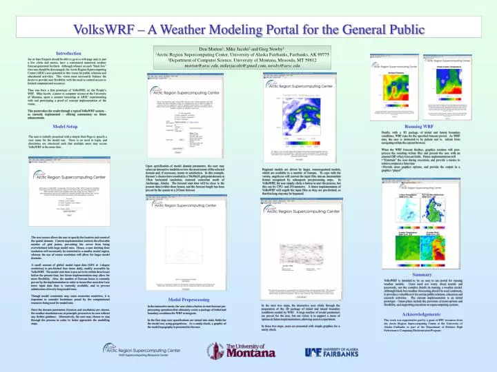
VolksWRF– A Weather Modeling Portal for the General Public Don Morton1, Mike Jacobi2 and Greg Newby1 1Arctic Region Supercomputing Center, University of Alaska Fairbanks, Fairbanks, AK 99775 2Department of Computer Science, University of Montana, Missoula, MT 59812 morton@arsc.edu, mikerjacobi@gmail.com, newby@arsc.edu Introduction Joe or Jane Sixpack should be able to go to a web page and, in just a few clicks and entries, have a customized numerical weather forecast generated for them. Although reliance on such “black box” forecasts should be discouraged, the Arctic Region Supercomputing Center (ARSC) sees potential in this vision for public relations and educational activities. This vision must necessarily balance the desire to provide user flexibility with the need to control access to limited computational resources. Thus was born a first prototype of VolksWRF, or, the People’s WRF. Mike Jacobi, a junior in computer science at the University of Montana, spent a summer internship at ARSC experimenting with and prototyping a proof of concept implementation of the vision. This poster takes the reader through a typical VolksWRF session – as currently implemented – offering commentary on future enhancements. Model Setup Running WRF • Finally, with a 3D package of initial and lateral boundary conditions, WRF runs for the specified forecast period. As WRF runs, the user is instructed to be patient and to refrain from navigating within the current browser. • When the WRF forecast finishes, graphics routines will post-process the resulting wrfout files and present the user with an aimated GIF of key forecast fields. Future implementations will • “Entertain” the user during execution, and provide a means to retrieve output at a later time • Provide more graphics options, and provide the output in a graphics “player” The user is initially presented with a simple Start Page to specify a case name for the model run. There is no need to login, and directories are structured such that multiple users may access VolksWRF at the same time. Upon specification of model domain parameters, the user may select an interactive model to review the areal extent of the selected domain and, if necessary, iterate to satisfaction. In this example, the user’s choices have resulted in a 50x50x28 grid point domain at 15km horizontal resolution, centered somewhat north of Anchorage, Alaska. The forecast start time will be close to the present time (within three hours), and the forecast length has been pre-set by the system to a 24 hour forecast. Regional models are driven by larger, coarser-grained models, which are available in a number of formats. To cope with the variety, ungrib.exe will convert the input files into an intermediate format recognized by subsequent pre-processing steps. In VolksWRF, the user simply clicks a button to start the process, but this can be CPU- and I/O-intensive. A future implementation of VolksWRF will ungrib the input files as they are pre-fetched, so that this long step may be bypassed. The next screen allows the user to specify the location and extent of the spatial domain. Current implementation restricts the allowable number of grid points, preventing the server from being overwhelmed with large model runs. Hence, a user desiring finer resolution will necessarily be restricted to a smaller model region, whereas the use of coarse resolution will allow for larger model domains. A small amount of global model input data (GFS at 1-degree resolution) is pre-fetched four times daily, readily accessible by VolksWRF. The model start time is pre-set to be within three hours before the present time, but future implementations may allow for more flexibility. Also, the number of forecast hours is currently pre-set by the implementation in order to insure that users don’t use more input data than is currently available, and to prevent submissions of overly-long model runs. Though model constraints may seem somewhat restrictive, it is important to consider limitations posed by the computational resources being used for model runs. Once the domain parameters (location and resolution) are chosen, the weather simulation can, in principle, proceed on its own without any further guidance. Alternatively, the user may choose to step through the process in order to better appreciate the modelling steps. Summary VolksWRF is intended to be an easy to use portal for running weather models. Users need not worry about userids and passwords, nor the complex details in running a weather model. Although black-box weather forecasting should be used cautiously, it provides a valuable tool for certain public relations, education and research activities. The current implementation is an initial prototype – future plans include the provision of more options and flexibility, and supporting execution on supercomputing systems. Model Preprocessing In the next two steps, the interactive user clicks through the preparation of the 3D package of initial and lateral boundary conditions needed by WRF. A large number of model parameters are pre-set for the user, but our vision is to support a menu of options in future implementations, allowing users to experiment. In these two steps, users are presented with simple graphics for a sanity check. In the interactive mode, the user clicks a button to start forecast pre-processing operations that ultimately create a package of initial and boundary conditions for WRF to integrate. In the first step, user specifications are turned into static fields for the model run, using geogrid.exe. As a sanity check, a graphic of the model topography is presented to the user. Acknowledgements This work was supported in part by a grant of HPC resources from the Arctic Region Supercomputing Center at the University of Alaska Fairbanks as part of the Department of Defense High Performance Computing Modernization Program.