Download

1 / 71
780 likes | 1.32k Views
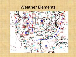
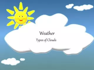
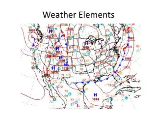
Weather Elements. Know basic facts and general principles of the elements of weather. 1. Identify types of clouds. 2. Identify types of air masses and fronts. 3. Describe terrain factors that affect weather. 4. Describe types of turbulence. 5. Identify normal weather patterns. Overview.

E N D
Weather Elements Know basic facts and general principles of the elements of weather. 1. Identify types of clouds. 2. Identify types of air masses and fronts. 3. Describe terrain factors that affect weather. 4. Describe types of turbulence. 5. Identify normal weather patterns.
Overview 1. Clouds 2. Air Masses and Fronts 3. Terrain Factors 4. Turbulence 5. Normal Weather Patterns
Low Clouds • Stratus • Sheet - like cloud. • No turbulence. • May be risen fog. • Light drizzle or snow. • Close to Earth’s surface. • Can hide danger.
Low Clouds • Stratocumulus • Rolls or global masses. • Bulbous protrusions. • Heavy rain and snow • Varying turbulence. • Masks higher severe cloud buildups.
Low Clouds • Cumulonimbus • Vertical growth group. • Top has anvil shape. • High winds, snow, hail, rain, lightning, and tornadoes. • Extreme turbulence.
Low Clouds • Nimbostratus • Shapeless, low-level, moderate precipitation. • Fog and precipitation found beneath. • Visibility restricted. • Calm to light winds.
Middle Clouds • Altostratus • Relatively thin. • Sun may be seen through veil. • Ice crystals and super-cooled water. • Light precipitation. • Poor surface visibility.
Middle Clouds • Altocumulus • Wavy solid clouds with rounded outline. • Light intermittent rain or snow. • Commonly followed by thunderstorms. • Poor visibility and moderate surface winds.
High Clouds • Cirrus • Thin feathery clouds. • No precipitation. • Sign of approaching bad weather.
High Clouds • Cirrostratus • Thin, resembles a sheet or veil. • No precipitation. • Nearly transparent. • Often sign of approaching bad weather.
High Clouds • Cirrocumulus • Thin clouds. • Indicates high-level instability. • Similar to cirrostratus but they have a slightly “bumpy” appearance.
Fracto and Lenticular • Fracto • Broken and/or ragged. • Cumulus fractos. • Lenticular • Lens-like shape. • Tells turbulence, visibility, precipitation.
Cumulus with Vertical Growth • Fair weather cumulus • A puffy, cottonball appearance. • Develops from thermal updrafts. • Flights below can be bumpy and choppy.
Cumulus with Vertical Growth • Vertical growth, or building cumulus • Produce strong rain and moderate to severe turbulence. • Very strong updrafts. • With further building and increase in intensity, it becomes a thunderstorm.
Fog Types • Radiation Fog • Formed at night when land surfaces radiate much of the heat absorbed from the Sun back into space. • The cool land surface cools the air near it to below the dew point and fog is formed.
Fog Types • High Inversion Fog • A low fog. • Formed by condensation of water vapor at or near the top of cool air, which is overlain by a warmer air layer.
Fog Types • Advection Fog • Formed when wind blows moist air over a cold surface. • When the surface cools the air to its dew point temperature, fog is formed.
Fog Types • Evaporation Fog • Also called steam fog, may occur when cold air moves over warm water. • The water’s normal evaporation process saturates the cooler air with water vapor and the dew point is reached.
Fog Types • Upslope Fog • Results when wind carries moist air up to a mountain slope or sloping land. • The air cools to its dew point as it rises and water vapor then condenses into fog.
Air Mass • A large body of air (usually extending over an area 1,000 or more miles across) which has generally the same temperature and moisture content within the entire mass.
Air Mass Type and Origination • Air masses are identified by letter symbols. • A polar air mass (P) is cold. • A tropical air mass (T) is hot. • A maritime air mass (m) forms over water and is humid. • A continental air mass (c) forms over land and is dry.
Air Mass Type and Origination • Aviators and meteorologists in the continental United States are chiefly concerned with air masses origination at two sources. • Masses that move southward from Polar Regions. • Masses that move northward from Tropical Regions.
Air Mass Type and Origination • Cold air masses • Continental polar (cP) • Maritime polar (mP) • Arctic (A)
Air Mass Type and Origination • The principle warm air mass is maritime tropic (mT)
Temperature Classification of Air Masses • Based upon its temperature in relation to the surface over which it passes. • A cold air mass (k) is cooler than the Earth’s surface over which it is moving. • A warm air mass (w) is warmer than the Earth’s surface over which it is moving.
Temperature Classification of Air Masses • Continental polar cold (cPk) - originates in the polar zone and moves south over a warm surface. • Maritime tropical warm (mTw) - originates over the Gulf of Mexico and moves toward the north over a cold surface.
Characteristics of Air Masses • Air masses originating in the tropical and equatorial areas move toward the northeast. • Air masses originating in the arctic and polar area move toward the southeast.
Characteristics of Air Masses • Cold air masses move more rapidly than warm air masses. • The weather generally depends on the nature of a prevailing air mass or the interaction of two or more air masses.
Characteristics of Air Masses • As an air mass moves away from its source, its original characteristics are changed because of the surface it passes over. It may: • Become warmer or colder. • Absorb or lose moisture. • Be lifted up by mountains or subside into valleys.
Fronts • The boundaries between air masses are called frontal zones or fronts. • This boundary or front moves along the Earth’s surface as one air mass displaces another. • If a cold air mass replaces a warmer air mass, the boundary is called a cold front. • If a warm air mass replaces a cold air mass, the boundary is called a warm front.
Fronts • Cold Fronts • Northwest to southeast. • Cold fronts travel very far south. • Amount of energy depends on amount of cold air in high-pressure cell. • Formed at the junction of the high-pressure. cold air with low-pressure warm air. • Cold air forces the warm air upward.
Fronts • Cold Fronts • Movement depends on condition of the warm air it collides with. • In western states, the noticeable change is shift of wind, temperature, and blowing dust. • In southern and eastern states it causes problems for aviators.
Fronts • Cold Fronts • As warm air is forced upward, it cools, condenses into clouds, creating thunderstorms. • If movement is rapid, with an abundance of water vapor, violent weather takes place. • Squall lines develop ahead of the front.
Fronts • Cold Fronts • Along the cold front there will be a low-pressure cell where the weather is at its worst. • Almost any type of clouds can be found near the cell. • Poor visibility, low ceilings and rain in summer. • Freezing rain and snow in winter.
Fronts • Warm Fronts • Connected to a low-pressure cell, travels northeastward. • If cell did not move, the front would dissipate. • Front slips upward over cool air and forms a wedge. • Rises slowly which delays condensation.
Fronts • Warm Fronts • Front is announced by cirrus clouds. • As front approaches other clouds, skies darken. • Near the frontal boundary, clouds are low, gentle rain falls and visibility is poor. • Warm rain falling into cooler air causes fog.
Fronts • Warm Fronts • After front passes, there is a rise in temperatures, general clearing and change in wind direction. • In winter a warm front causes icing conditions at low altitudes. • In northern latitudes snow may also be produced.
Fronts • Stationary Front • When air masses stop, a stationary front develops. • Weather can be bad for aviation along the front. • About every form of weather can be found.
Front • Stationary Front • Toward the trailing edge of the any front there will be a stationary-front condition. • The trailing edge stationary fronts are a great distance from the parent cell. • As the distance become greater the front no longer exists.
Front • Occluded Front • There is a tendency for a horizontal bend or wave to occur along the front. • After a frontal bend starts, cold air moves ahead of a warm front. • The cold section moves faster than the warm section.
Front • Occluded Front • The resulting front is called occluded or occlusion. • Air pressure becomes less at the wave or bend than at other points. • The weather that results is a combination of cold and warm front weather.