Download
1 / 22
240 likes | 410 Views
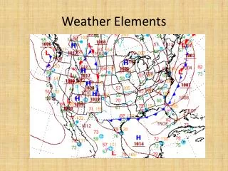
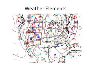
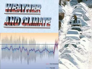
Weather Elements. Summary from Lesson 2. Conduction. ____________ is the passage of energy, particularly heat and electricity, through an object. An example is a frying pan

E N D
Summary from Lesson 2 Conduction • ____________ is the passage of energy, particularly heat and electricity, through an object. An example is a frying pan • ____________ is the process whereby air absorbs heat energy. Warm air is forced upward as cold air flows displace the warm air. • The horizontal transfer of a heat, caused by air movement is called ________________. A good example is fog. • ________________ is the rate at which the Earth’s surface is heated by solar radiation. Convection Advection Insolation
Weather Elements Know basic facts and general principles of the elements of weather. 1. Identify types of clouds. 2. Identify types of air masses and fronts.
Overview 1. Clouds 2. Air Masses and Fronts
Low Clouds(300 – 6,500 ft) • Stratus • Sheet - like cloud. • No turbulence. • May be risen fog. • Light drizzle or snow. • Close to Earth’s surface. • Can hide danger.
Low Clouds • Stratocumulus • Rolls or global masses. • Bulbous protrusions. • Heavy rain and snow • Varying turbulence. • Masks higher severe cloud buildups.
Low Clouds • Cumulonimbus • Vertical growth group. • Top has anvil shape. • High winds, snow, hail, rain, lightning, and tornadoes. • Extreme turbulence.
Middle Clouds(6,500 – 20,000 ft) • Altostratus • Relatively thin. • Sun may be seen through veil. • Ice crystals and super-cooled water. • Light precipitation. • Poor surface visibility.
Middle Clouds • Altocumulus • Wavy solid clouds with rounded outline. • Light intermittent rain or snow. • Commonly followed by thunderstorms. • Poor visibility and moderate surface winds.
High Clouds(20,000 ft and up) • Cirrus • Thin feathery clouds. • No precipitation. • Sign of approaching bad weather.
High Clouds • Cirrocumulus • Thin clouds. • Indicates high-level instability. • Similar to cirrostratus but they have a slightly “bumpy” appearance.
Fog Types • Radiation Fog • Formed at night when land surfaces radiate much of the heat absorbed from the Sun back into space. • The cool land surface cools the air near it to below the dew point and fog is formed.
Fog Types • Advection Fog • Formed when wind blows moist air over a cold surface. • When the surface cools the air to its dew point temperature, fog is formed.
Fog Types • Upslope Fog • Results when wind carries moist air up to a mountain slope or sloping land. • The air cools to its dew point as it rises and water vapor then condenses into fog.
Air Mass • A large body of air (usually extending over an area 1,000 or more miles across) which has generally the same temperature and moisture content within the entire mass.
Characteristics of Air Masses • Cold air masses move more rapidly than warm air masses.
Fronts • The boundaries between air masses are called frontal zones or fronts. • If a cold air mass replaces a warmer air mass, the boundary is called a cold front. • If a warm air mass replaces a cold air mass, the boundary is called a warm front.
Fronts • Cold Fronts • As warm air is forced upward, it cools, condenses into clouds, creating thunderstorms. • Squall lines develop ahead of the front.
Fronts • Warm Fronts • Front slips upward over cool air and forms a wedge. • Rises slowly which delays condensation. • As front approaches other clouds, skies darken. • Near the frontal boundary, clouds are low, gentle rain falls and visibility is poor.
Summary 1. Clouds 2. Air Masses and Fronts