Download
1 / 26
260 likes | 401 Views
Relating Data to a Seamless Vertical Reference Surface. Ruth Adams, UK Hydrographic Office, UK. Why Seamless Data?. Hydrographic surveying. ECDIS applications. Defence capabilities. Coastal Zone Management. User choice of output datum. Marine boundary delimitation.

E N D
Relating Data to a Seamless Vertical Reference Surface Ruth Adams, UK Hydrographic Office, UK
Why Seamless Data? Hydrographic surveying ECDIS applications Defence capabilities Coastal Zone Management User choice of output datum Marine boundary delimitation
What is a seamless vertical datum? • Vertical datum = surface to which heights (or depths) of points are referred. • A seamless vertical datum is one which does not vary over time or location.
Variable Vertical Datum But Chart Datum is not seamless! It varies spatially. For example the difference between Chart Datum and Ordnance Datum Newlyn is: -2.80m at Torquay -1.50m at Lowestoft -6.10m at Barry +0.60m at Barnstaple
A Seamless Surface? A stable reference surface which could be considered suitable for this is WGS84 Datum … Although a regional realisation may be more appropriate
Vertical Datums • The ultimate aim is to refer all heights and depths to WGS84 Datum. • Currently land applications use MSL or a local land datum (for example) for their heighting whereas marine applications use Chart Datum and MHWS. • It is relatively straight-forward to transform land detail to WGS84 Datum but data referred to Chart Datum is not easy to convert.
The Challenge The challenge is not so much to develop a seamless vertical reference surface, but to develop a way of relating current and future datasets to it in a seamless manner.
How do you Develop a Vertical Datum Separation Model? • It depends on available information… • For example • What bathymetric and topographic data is held? • Are there ellipsoidal heights at Chart Datum points? • Is there an accurate geoid model? • And it depends on the accuracy needed
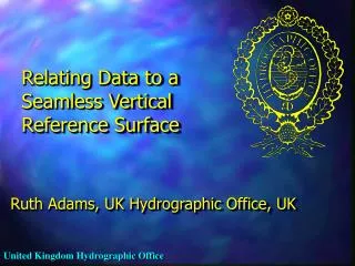
UK Example - VORF Using a geoid model, can obtain relationship between Chart Datum and ETRS89 (a European realisation of WGS84 Datum) • Connections are known between Chart Datum and ODN (Ordnance Datum Newlyn) at tide stations onshore.
Vertical Datum Separation Model Contours show CD to OS vertical datum (ODN) separation. Red is 6 metres separation; yellow is 0 metres separation with 0.5 metre interval.
How Good is this Model? • Still relies on co-tidal models – only guaranteed to be accurate to +/- 0.5m in vertical accuracy. • Does this reflect the current minimum sea surface? • What does the Mariner need?
The Way Ahead • UKHO will develop a new minimum sea surface related to ETRF89. • UKHO will develop a Chart Datum to ETRF89 Datum separation model. • UKHO will also develop a Chart Datum to minimum sea surface corrector surface.
Coastline Corrector Surface between CD and Minimum Sea Surface ODN Geoid VORF Model CD OSGM 02 ( Corrector Surface ) ICZM Model CD-ODN diff from ATT OSGM 02 ETRF89 Complex Datum Surfaces Around the Coast Minimum Ref. Surface Min. Sea Surface
The UKHO Model • This could be done using modern satellite data – expected accuracy +/- 0.2m 1 sigma. • It is planned to match the area covered by OSGM02 • SW 012°W, 48°N • SE 004°E, 48°N • NE 004°E, 62°N • SE 012°W, 62°N • Work is in hand to put out the contract and it is anticipated we will have a working model for research purposes by early 2007.
Developing the VORF 1.Develop a mean sea surface using satellite altimetry and geoid modelling 2.Use tidal modelling to derive minimum sea surface
Satellite Altimetry - Ground Tracks • TOPEX/POSEIDON ground track • Along track spacing 6-7 km • Across track spacing 315km • Additional data from other satellites • ENVISAT • ERS2 • Future satellites – 200km wide swath “Can be likened to the deployment of thousands of tide gauges across the ocean”
Tidal Modelling • Once this MSL has been established the new minimum sea surface will be derived using tidal models provided by Proudman Oceanographic Laboratory, POL.
VORF Project Latest • Notice placed in the OJEU, inviting expressions of interest in the VORF project. • Tenders were submitted and have been evaluated. • Contract has been let with UCL.
Other Vertical Datum Separation Models The UKHO methodology is only one of the many ways to develop a vertical datum separation model
Canadian Example • The Canadian Hydrographic Service have used satellite altimetry and tidal models to develop a Chart Datum model offshore
US Example • In Tampa Bay NOAA developed a Chart Datum model using a hydrodynamic tidal model and a known relationship to NAD83 (a US realisation of WGS84).
Keep the Goal in Mind • Don’t create a high accuracy, expensive model if a lower accuracy one will suffice – keep in mind the purpose of the model • What area will the model cover? • Have neighbouring nations already developed similar models which can be extended? • Is the aim to re-create Chart Datum or develop a model of the minimum sea surface? • What resources are available? • What storage requirements will the model have? • How will the model be maintained?
Conclusions • Seamless vertical data is vital to future hydrographic requirements. • Chart Datum is not seamless and data must be referred to another vertical datum. This can be via a vertical datum separation model. • The challenge is to develop this model so that historic, current and future data can be merged.
Thank you for listening Ruth Adams UK Hydrographic Office