Download
1 / 30
300 likes | 307 Views
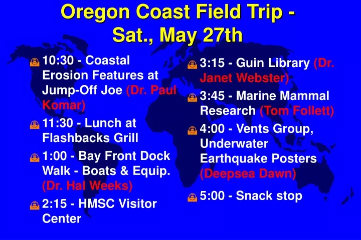
10:30 - Coastal Erosion Features at Jump-Off Joe (Dr. Paul Komar) 11:30 - Lunch at Flashbacks Grill 1:00 - Bay Front Dock Walk - Boats & Equip. (Dr. Hal Weeks) 2:15 - HMSC Visitor Center. 3:15 - Guin Library (Dr. Janet Webster) 3:45 - Marine Mammal Research (Tom Follett)

E N D
10:30 - Coastal Erosion Features at Jump-Off Joe (Dr. Paul Komar) 11:30 - Lunch at Flashbacks Grill 1:00 - Bay Front Dock Walk - Boats & Equip. (Dr. Hal Weeks) 2:15 - HMSC Visitor Center 3:15 - Guin Library (Dr. Janet Webster) 3:45 - Marine Mammal Research (Tom Follett) 4:00 - Vents Group, Underwater Earthquake Posters (Deepsea Dawn) 5:00 - Snack stop Oregon Coast Field Trip - Sat., May 27th
Tracking Currents:The Story of the Lost Nikes • 1: 60,000 shoes spilled, May 1990 • 2-8: 1990-’91 • 9: 1993 • 10: Predicted 1994
Deep Ocean Circulation Chapter 6
Ocean Currents • Wind-driven • Set in motion by moving air masses • Horizontal currents • Primarily near the surface
Winds-->Ekman T.-->Mounds-->Geostrophic Flow • Geostrophic flows are the major currents • a balance between a pressure gradient and Coriolis deflection • Western currents faster
Ekman Transport The Coriolis deflection results in a spiral movement of water.
Ocean Currents • Thermohaline • Initiated at the surface by temp/salinity • Vertical circulation • Primarily at depth
Deep-Ocean Circulation • Powered by thermohaline circulation due to density differences between water masses. The differences reflect • Temperature - thermal • Salinity - haline
“You are my DENSITY!”-- George McFly • Density of water determined primarily by temperature and salinity • pressure effects are negligible. • Density near surface: • Evaporation • Precipitation • Runoff, river drainage
Water Masses at Depth • When water masses sink they are isolated from the major processes that affect density. • Hence they retain the temperature and salinity signature established at the sea surface. • Mixing is slow because flow rates are very slow.
Water Mass Types • Central Waters e.g., NPCW = North Pacific Central Water • Intermediate Waters e.g., NPIW = North Pacific Intermediate Water • Deep and Bottom Waters e.g., CoW = Common Water NADW = North Atlantic Deep Water AABW = Antarctic Bottom Water
Thermohaline “Conveyer Belt” • At the poles: • cold, salty dense water sinks and spreads into the ocean basins along the bottom. • At the equator: • warm low density water floats as a lens slowly moving poleward. • Water that sinks at the poles takes about 1500 years to rise back to the surface.
Water Mass Structure of the Atlantic(Figures 6-15 and 6-B7) Oxygen-rich: Cold water can “stuff” gases into Itself better than warm water
Water Mass Structure of the Pacific(Figure 6-15) Pacific Subarctic Water Common Water
Why is deep water formed in Atlantic?Why is the Atlantic saltier?