Download
1 / 7
70 likes | 76 Views
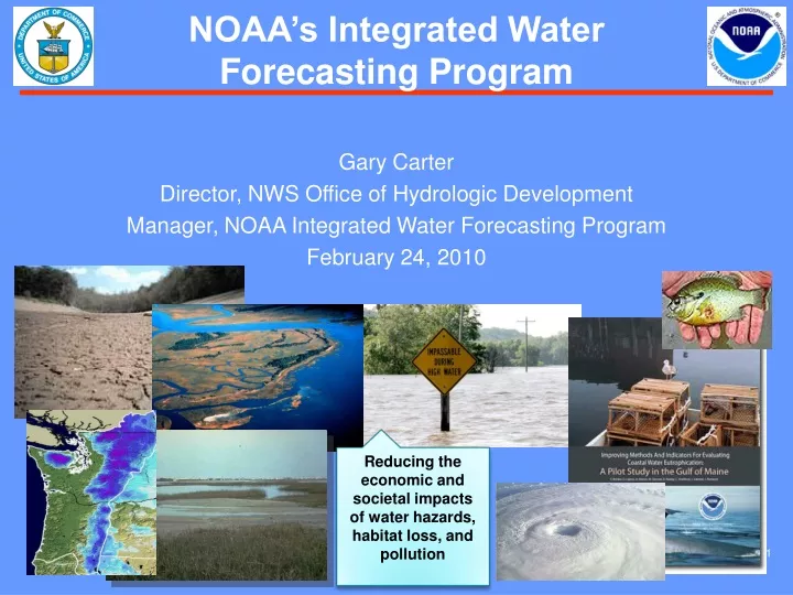
NOAA's Integrated Water Forecasting Program aims to produce seamless water forecast information to mitigate natural hazards, manage water resources, and protect ecosystems. The program covers floods, droughts, sea-level rise, and short-term warnings with an emphasis on climate-related impacts. It includes hydrologic ensemble forecast services, community-focused water information, and integrated water resources science and services. Through research, development, and delivery of water science and forecasting services, NOAA aims to improve flood forecasting capabilities and accelerate the transition to new technologies and models. The program also leads pilot projects for improved nationwide water resource management.

E N D
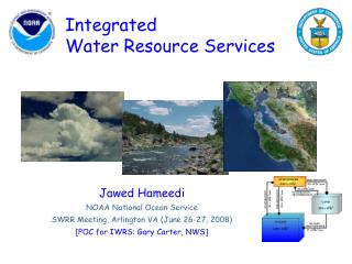
Reducing the economic and societal impacts of water hazards, habitat loss, and pollution NOAA’s Integrated Water Forecasting Program Gary Carter Director, NWS Office of Hydrologic Development Manager, NOAA Integrated Water Forecasting Program February 24, 2010
NOAA Forecasts Water The three business areas of NOAA’s Integrated Water Forecasting Programare aimed at producing a seamless suite of water forecast information, covering: Floods Droughts Summit Sea Short-term Warnings Seasonal Outlooks with increased emphasis on climate-related impacts for arid and coastal watersheds. IWFP Business Areas
Community Focused Water Information Leveraging NOAA capabilities to: • Expand hydrologic services to coastal watersheds without existing freshwater forecasts • Coordinate the delivery and dissemination of integrated water products and services to mitigate natural hazards, and wisely manage water resources and ecosystems
Integrated Water Resources Science and Services • Leap Ahead • Implement information and tools for next-generation adaptive water-related planning, preparedness and response activities National Water Resources Information System 3 Goals 2 1
Water Resources Research to Operations – PB FY 11 and beyond • Why • Extreme precipitation events create both beneficial water supply and dangerous floods with significant economic and societal impacts, and yet they remain to be a great challenge facing hydrometeorological forecasters. Dramatic advances in science and services are required to meet these needs. What • NOAA will research, develop and deliver water science and forecasting services to integrate river, estuary and coastal flood-forecast capabilities. • HMT focuses on accelerating the necessary research to infuse new observing technologies and strategies, precipitation forecast model improvements, and advanced precipitation science into NOAA’s forecasting services ($5M). • CERIS develops and transitions to NWS River Forecast Center and Weather Forecast Office operations new river, estuary and coastal flood-forecast capabilities and estuarine ecosystem health services by using the Tar River Basin and Pamlico Sound in North Carolina for operational prototyping ($1.2M). • THORPEX is an international program to improve the analysis and prediction of high impact weather events out to fourteen days with advances in precipitation forecasts being the key objective ($1.4M).
Pilot Project: Interagency Water Resources Science & Services NOAA Integrated Water Forecasting program will lead a Proof-of-Concept demonstration of improved, integrated nationwide water resource management capability (USACE and USGS will be primary partners) Forecast models and service delivery capability will be applied to expanded observational networks and advanced data assimilation techniques National Mesonet observations, NOAA IOOS environmental data, and partner environmental data will be integrated and manipulated using newly developed water resource management systems for coastal watersheds Primary benefit of successful demonstration: Water resource managers at the local, regional and national level will make more accurate decisions Primary deliverable will be annual Proof-of-Concept reports to NOAA Leadership and the Council on Environmental Quality (CEQ) Predecisional NOAA Program FY 12 and beyond