Download
1 / 35
350 likes | 477 Views
A Geographically-Broad Assessment of Rangeland Ecosystem Services. Shannon White, Shannon.white@ualberta.ca Thomas J. Habib, and Dan Farr Alberta Biodiversity Monitoring Institute University of Alberta. A Geographically-Broad Assessment of Rangeland Ecosystem Services. Shannon White,

E N D
A Geographically-Broad Assessment of Rangeland Ecosystem Services Shannon White, Shannon.white@ualberta.ca Thomas J. Habib, and Dan Farr Alberta Biodiversity Monitoring Institute University of Alberta
A Geographically-Broad Assessment of Rangeland Ecosystem Services Shannon White, Shannon.white@ualberta.ca Thomas J. Habib, and Dan Farr Alberta Biodiversity Monitoring Institute University of Alberta
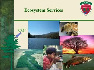
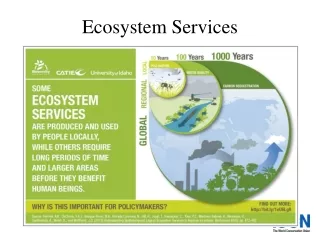
Rangelands provide all these services (and more) Forage production Pollination Carbon storage Biodiversity Water filtration & storage Species at risk
ES in AB Rangelands • AB has twice the remaining untilled prairie than the US • Conversion continues • Current market doesn’t account for ES • New markets for ranchers
Status of Rangeland • Less than half of rangeland in “good” condition (Prairie Agricultural Landscapes, AAFC) • Potential to better manage rangelands • Especially if there is incentive
Status of Rangeland Less than half of rangeland in “good” condition (Prairie Agricultural Landscapes, AAFC) Potential to better manage rangelands Especially if there is incentive
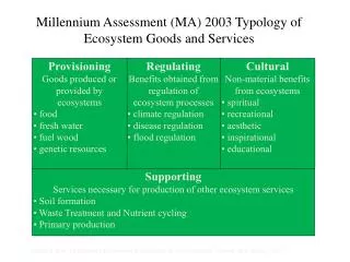
Ecosystem Services Assessment Project • Develop detailed, spatially-explicit models to measure and map these focal ES across Alberta, as well as how they change with land management activities • Part of a province-wide initiative led by AIBio, the Ecosystem Services Research and Innovation Roadmap • Will further incorporate this knowledge into market-based instruments
Quantifying ES • Water purification • Pollination • Biodiversity • Carbon storage • Forage production • Timber production
Quantifying ES • Water purification • Pollination • Biodiversity • Carbon storage • Forage production • Timber production • “Beta release March 2014” • Open source; open data
Water purification Track water flow using DEM Water picks up sediment based on landcover/ land-use Track sediment deposition Determine important upslope source areas for points of interest (e.g. cities, recreational lakes)
Pollination Map canola fields
Pollination Map canola fields Map bee habitat
Pollination Map canola fields Map bee habitat Use field studies to understand contribution of bees to canola production
Pollination Map canola fields Map bee habitat Use field studies to understand contribution of bees to canola production Determine $/ha
Biodiversity (ABMI) Monitor species abundance and habitat across province
Biodiversity Monitor species abundance and habitat across province Develop detailed maps of land cover & use
Biodiversity Monitor species abundance and habitat across province Develop detailed maps of land cover & use Develop statistical relationships between land use and observed species
Biodiversity • Monitor species abundance and habitat across province • Use detailed map of land use • Develop statistical relationships between land use and observed species • Use these relationships to predict biodiversity “Intactness” across province
Forage production & Carbon storage • Uses CENTURY ecosystem model • Soil Organic Matter • Plant Production • Hydrological • Nutrient Cycling • Management and events
Forage production & Carbon storage Uses CENTURY model Based on soil, climate & land cover data
Forage production & Carbon storage Uses CENTURY model Based on soil, climate & land cover data Run model for each Agrasid polygon
Forage production & Carbon storage Uses CENTURY model Based on soil, climate & land cover data Run model for each Agrasid polygon Link results to GIS (native grassland)
Results: Carbon Modelling Total Soil C (tonnes/ha) μ = 87 tonnes C/ha
Results: Carbon Modelling Total Soil C (tonnes/ha) μ = 87 tonnes C/ha μ = 319 tonnes CO2/ha
Results: Carbon Modelling Total Soil C (tonnes/ha) μ = 87 tonnes C/ha μ = 319 tonnes CO2/ha
Results: Forage Modelling Available Forage (kg/ha/yr) μ = 2391 kg/ha
Results: Forage Modelling Available Forage (kg/ha/yr) μ = 2391 kg/ha Value? $60/tonne? $143/ha/yr3
Caveat • Preliminary results • Modelling • Benefits • Drawbacks • CENTURY is well used model • But need model validation
What questions can we ask? • Large spatial extent: what is the value? • Effect of land use/management • Conversion of prairie to cropland • Adjusting grazing intensity • Trade-offs between multiple ES • How will climate change affect ES? • Scaling down
Applications • Scorecards • For a region, or industry • Scenario modelling • Market-based instruments • i.e. Conservation offsets • Payment for ecosystem services…
Carbon Credits for Grassland >4X C in soil than atmosphere
Carbon Credits for Grassland Accounting based off CENTURY model
Acknowledgements Funders: Collaborators: