Download
1 / 1
10 likes | 88 Views
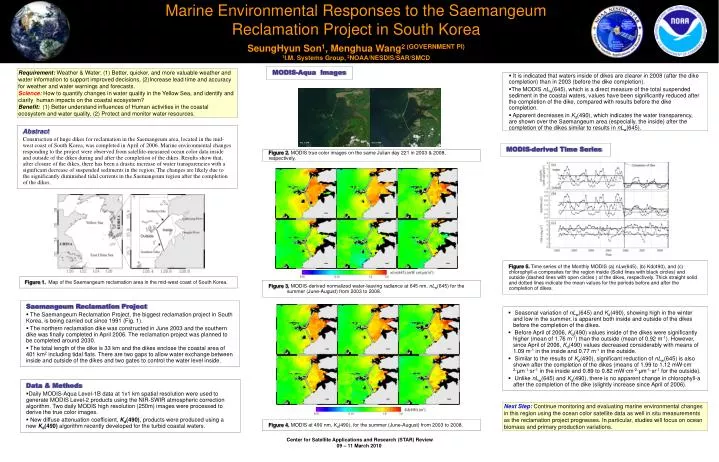
Marine Environmental Responses to the Saemangeum Reclamation Project in South Korea. SeungHyun Son 1 , Menghua Wang 2 (GOVERNMENT PI) 1 I.M. Systems Group, 2 NOAA/NESDIS/SAR/SMCD. MODIS-Aqua Images.

E N D
Marine Environmental Responses to the Saemangeum Reclamation Project in South Korea SeungHyun Son1, Menghua Wang2 (GOVERNMENT PI) 1I.M. Systems Group, 2NOAA/NESDIS/SAR/SMCD MODIS-Aqua Images Requirement: Weather & Water: (1) Better, quicker, and more valuable weather and water information to support improved decisions, (2)Increase lead time and accuracy for weather and water warnings and forecasts. Science:How to quantify changes in water quality in the Yellow Sea, and identify and clarify human impacts on the coastal ecosystem? Benefit: (1) Better understand influences of Human activities in the coastal ecosystem and water quality, (2) Protect and monitor water resources. • It is indicated that waters inside of dikes are clearer in 2008 (after the dike completion) than in 2003 (before the dike completion). • The MODIS nLw(645), which is a direct measure of the total suspended sediment in the coastal waters, values have been significantly reduced after the completion of the dike, compared with results before the dike completion. • Apparent decreases in Kd(490), which indicates the water transparency, are shown over the Saemangeum area (especially, the inside) after the completion of the dikes similar to results in nLw(645). Abstract Construction of huge dikes for reclamation in the Saemangeum area, located in the mid-west coast of South Korea, was completed in April of 2006. Marine environmental changes responding to the project were observed from satellite-measured ocean color data inside and outside of the dikes during and after the completion of the dikes. Results show that, after closure of the dikes, there has been a drastic increase of water transparencies with a significant decrease of suspended sediments in the region. The changes are likely due to the significantly diminished tidal currents in the Saemangeum region after the completion of the dikes. Aug. 9, 2003 Aug. 8, 2008 MODIS-derived Time Series Figure 2. MODIS true color images on the same Julian day 221 in 2003 & 2008, respectively. 2003 2004 2005 2006 2007 2008 Figure 5. Time series of the Monthly MODIS (a) nLw(645), (b) Kd(490), and (c) chlorophyll-a composites for the region inside (Solid lines with black circles) and outside (dashed lines with open circles ) of the dikes, respectively. Thick straight solid and dotted lines indicate the mean values for the periods before and after the completion of dikes. Figure 1. Map of the Saemangeum reclamation area in the mid-west coast of South Korea. Figure 3. MODIS-derived normalized water-leaving radiance at 645 nm, nLw(645) for the summer (June-August) from 2003 to 2008. Saemangeum Reclamation Project • The Saemangeum Reclamation Project, the biggest reclamation project in South Korea, is being carried out since 1991 (Fig. 1). • The northern reclamation dike was constructed in June 2003 and the southern dike was finally completed in April 2006. The reclamation project was planned to be completed around 2030. • The total length of the dike is 33 km and the dikes enclose the coastal area of 401 km2 including tidal flats. There are two gaps to allow water exchange between inside and outside of the dikes and two gates to control the water level inside. • Seasonal variation of nLw(645) and Kd(490), showing high in the winter and low in the summer, is apparent both inside and outside of the dikes before the completion of the dikes. • Before April of 2006, Kd(490) values inside of the dikes were significantly higher (mean of 1.76 m-1) than the outside (mean of 0.92 m-1). However, since April of 2006, Kd(490) values decreased considerably with means of 1.09 m-1 in the inside and 0.77 m-1 in the outside. • Similar to the results of Kd(490), significant reduction of nLw(645) is also shown after the completion of the dikes (means of 1.99 to 1.12 mW∙cm-2∙μm-1∙sr-1 in the inside and 0.89 to 0.82 mW∙cm-2∙μm-1∙sr-1 for the outside). • Unlike nLw(645) and Kd(490), there is no apparent change in chlorophyll-a after the completion of the dike (slightly increase since April of 2006). 2003 2004 2005 Data & Methods • Daily MODIS-Aqua Level-1B data at 1x1 km spatial resolution were used to generate MODIS Level-2 products using the NIR-SWIR atmospheric correction algorithm. Two daily MODIS high resolution (250m) images were processed to derive the true color images. • New diffuse attenuation coefficient, Kd(490), products were produced using a new Kd(490) algorithm recently developed for the turbid coastal waters. 2006 2007 2008 Next Step:Continue monitoring and evaluating marine environmental changes in this region using the ocean color satellite data as well in situ measurements as the reclamation project progresses. In particular, studies will focus on ocean biomass and primary production variations. Figure 4. MODIS at 490 nm, Kd(490), for the summer (June-August) from 2003 to 2008.