Download
1 / 5
50 likes | 206 Views
CIRA AMSU Tropical Cyclone Algorithm. 1. Retrieve T(x,y,z) from all AMSU-A channels 2. Correct T for rain and ice effects 3. Hydrostatic integration for P (x,y,z) 4. Gradient wind for V(r,z) 5. Statistical Prediction Independent Variables : Parameters from retrieved T, P, V

E N D
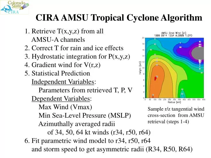
CIRA AMSU Tropical Cyclone Algorithm • 1. Retrieve T(x,y,z) from all • AMSU-A channels • 2. Correct T for rain and ice effects • 3. Hydrostatic integration for P(x,y,z) • 4. Gradient wind for V(r,z) • 5. Statistical Prediction • Independent Variables: • Parameters from retrieved T, P, V • Dependent Variables: • Max Wind (Vmax) • Min Sea-Level Pressure (MSLP) • Azimuthally averaged radii • of 34, 50, 64 kt winds (r34, r50, r64) • 6. Fit parametric wind model to r34, r50, r64 • and storm speed to get asymmetric radii (R34, R50, R64) V(r,Q) Sample r/z tangential wind cross-section from AMSU retrieval (steps 1-4)
2002 Real-Time Test • Algorithm developed from 1999-2001 Sample • 2002 Real-Time Runs • Initiated at 00, 06, 12, 18 UTC • Storm positions from ATCF • Analysis restricted to storms within 700 km of AMSU data swath • Results sent to TPC via ftp • Evaluation Samples • 1999-2001 Developmental cases (N=473) • 2002 All Atlantic/East Pacific cases (N=288) • 2002 Atlantic/East Pacific cases with recon (N=64) • Ground “Truth” for Evaluation • NHC Best Track Vmax and MSLP • NHC Forecast/Advisory for wind radii
Predicted vs. “Observed” Scatter Plots for 2002 Real-Time Runs (Total and Recon-Only Samples) Vmax MSLP R34 R50 R64
Error Summary for CIRA Algorithm:Developmental, 2002 All and 2002 Recon Samples Absolute Error Variance Explained Vmax MSLP Vmax MSLP Vmax and MSLP R34 R50 R64 R34 R50 R64 R34 R50 R64
Conclusions from 2002 Evaluation • Vmax, MSLP: • 2002 errors very similar to dependent sample • Intensity still underestimated for strongest storms • Test dependent variable transformation for improvement • Wind Radii: • 2002 recon-only errors generally similar to dependent sample • Tendency for high bias for R50 and R64 • Observed R50 and R64 more asymmetric than predicted • Test variable asymmetry factor (different for R34, 50 and 64) • Suggestion to JHT: • Re-develop algorithm with 2002 cases added • Nearly doubles dependent dataset • Test suggested improvements • Evaluate again following 2003 season