Download
1 / 4
40 likes | 194 Views
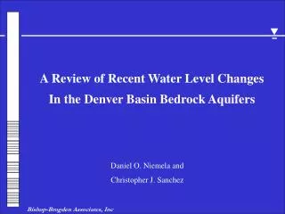
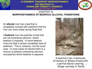
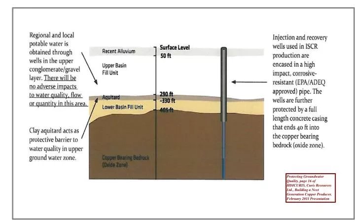
Protecting Groundwater Quality, page 16 of HDICURIS, Curis Resources Ltd., Building a Next Generation Copper Producer, February 2011 Presentation. 2000. 1500. 0. 1000. DEPTH (ft bls). 500. ELEVATION (amsl). 500. 1000. 0. 1500. 1700. WEST. EAST.

E N D
Protecting Groundwater Quality, page 16 of HDICURIS, Curis Resources Ltd., Building a Next Generation Copper Producer, February 2011 Presentation
2000 1500 0 1000 DEPTH (ft bls) 500 ELEVATION (amsl) 500 1000 0 1500 1700 WEST EAST Protecting Groundwater Quality, page 16 of HDICURIS, Curis Resources Ltd., Building a Next Generation Copper Producer, February 2011 Presentation Added by SGC, July 2011 Southwest Value Partners Well Riggins Farm Well (4-9)29DAB (4-9)29DAC (4-9)26CAD (4-9)26DBB (4-9)30DDA (4-9)29CBC CURIS ARIZONA PROPERTY UPPER BASIN FILL ALLUVIAL UNIT Static Water Level MIDDLE FINE-GRAINED UNIT LOWER BASIN FILL ALLUVIAL UNIT Ground-water Flow Direction (W-NW) PROPOSED INJECTION ZONE BEDROCK Enlarged Area of Cross Section Figure 14A-7, Generalized Regional Geologic Cross-Section A-A’, Curis Resources (Arizona) Inc., Florence, Arizona in HDICURIS, Curis Resources (Arizona) Inc., Florence Copper Project, Application to Amend Aquifer Protection Permit No. 101704, Volume 3 of 4, January 2011 Total Depth at 2,006 ft bls
WEST EAST Riggins Farm Well Southwest Value Partners Well Merrill Ranch Proposed Well Field 2000 P1,P2, & P3 P4 & P5 1500 0 UPPER BASIN FILL ALLUVIAL UNIT Static Water Level MIDDLE FINE-GRAINED UNIT 1000 500 DEPTH (feet) ELEVATION (amsl) Ground-water Flow Direction LOWER BASIN FILL ALLUVIAL UNIT 500 1000 Enlarged Area of Cross Section 0 1500 BEDROCK Map Source: Curis Resources, Ltd. March 24, 2011, Figure F-4 2000 Southwest Ground-water Consultants, Inc., July 8, 2011