Download
1 / 41
410 likes | 411 Views
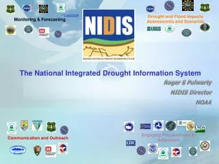
NIDIS aims to enhance the collection, interpretation, and dissemination of reliable drought data to provide timely information for decision-makers and the public. It focuses on early warning, forecasting, risk assessment, planning, and education.

E N D
The National Integrated Drought Information System (NIDIS): What is it? What does it do? Jim Verdin (USGS) and Roger Pulwarty (NOAA) NIDIS Program Office NOAA/ESRL Boulder, Colorado
“NIDIS should improve and expand the compilation of reliable data on the various indicators of droughts, and it should integrate and interpret that data with easily accessible and understandable tools, which provide timely and useful information to decision-makers and the general public.— Western Governor’s Association Report, June 2004 “(We) contend that we can reduce this nation’s vulnerability to the impacts of drought by making preparedness— especially drought planning, plan implementation, and proactive mitigation— the cornerstone of national drought policy..”— National Drought Policy Commission Report, May 2000 • “Characteristics of disaster-resilient communities”: • Relevant hazards are recognized and understood. • Communities at risk know when a hazard event is imminent. • Individuals at risk are safe from hazards in their homes and places of work. • Communities experience minimum disruption … after a hazard event has passed.” • — National Science and Technology Council, June 2005 • “Near-term opportunities identify observing systems or integration of components that meet high priority societal needs, and make improvements to inadequate existing systems that can be completed within 5 years and have tangible, measurable results. • Improved Observations for Disaster Warnings • Global Land and Sea Level Observation Systems • National Integrated Drought Information System • Air Quality Assessment and Forecast System • Architecture and Data Management.”— U.S. Group on Earth Observations, Sept. 2006
Principal Drought Outlook Inputs 2-Wk Soil Moisture CPC Long-Lead Precip. Outlook Constructed Analogue Soil Model Palmer 4-mo Probabilities Short-Range Fcst Medium-Range Fcst
Challenge: Diverse Temporal and Spatial Scales Droughts span an enormous range of temporal and spatial scales
Multiple competing valuesMultiple, competing objectives Hydropower Ecosystems health Recreation Consumptiveuse Flood control Agriculture
“No systematic collection and analysis of social, environmental, and economic data focused on the impacts of drought within the United States exists today” Western Governors Association 2004
NIDIS VISION and GOALS “A dynamic and accessible drought information system that provides users with the ability to determine the potential impacts of drought and the associated risks they bring, and the decision support tools needed to better prepare for and mitigate the effects of drought.”Public Law 109-430 (Signed by the President December 2006) (www.drought.gov)
NIDIS Objectives • Creating a drought early warning information system • Coordinating national drought monitoring and forecasting system • Providing an interactive drought information clearinghouse and delivery system for products and services—including an internet portal and standardized products (databases, forecasts, Geographic Information Systems (GIS), maps, etc) • Designing mechanisms for improving information to support coordinated preparedness and planning
NOAA Western Governors Association USGS Dept. of Interior (BoR) U.S. Army Corps of Engineers USDA (NRCS, ARS, CSREES) NASA Indigenous Waters Network Regional Climate Centers National Drought Mitigation Center Association of State Climatologists Cornell University New Mexico State University Rutgers University South Dakota State University University of Oklahoma University of South Carolina University of Washington The Weather Channel NIDIS Implementation Team Partners (to date): New: Duke Power U. Georgia Others? www.drought.gov
Early Warning System components • Monitoring and forecasting • Risk assessment: Indicators and triggers • Drought risk planning and preparedness • Drought Portal • Communication and Education
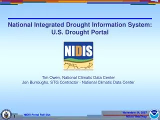
The U.S. Drought Portal (www.drought.gov) 2. 3. 1. Key Themes 1.) Current Drought 2.) Forecasting 3.) Impacts 4.) Planning 5.) Education 6.) Research Showcase Portlets: 1.) U.S. Drought Monitor (NOAA, USDA, NDMC) 2.) Drought Impacts Reporter (NDMC) 3.) Climate Prediction Center Seasonal Forecast (NOAA)
NIDIS Knowledge and Service Assessment Workshops • “Reconciling Projections of Future Colorado River Stream Flow”, Sept 2007/November 2008 • “Remote Sensing Contributions to Drought Monitoring”, February 6-7, 2008, Boulder • “NIDIS Southeast Drought Workshop” – April 29-30, 2008, Peachtree City, Georgia • “National Status of of Drought Early Warning Systems”, June 17-19, 2008, Kansas City
Tailoring and interpretation of national products needed for regional, watershed and local detail and usability Upscaling of local data to create regionally specific monitors and risk assessment
NOAA & NOAA-Supported Centers International Research Institute RISA – Pacific Northwest High Plains RCC University of Nebraska Midwestern RCC Illinois State Water Survey RISA – Western Water RISA – NewHampshire Northeast RCC Cornell University Western RCC Desert Research Institute Climate Prediction Center, Climate Services Division Climate Diagnostic Center National Climatic Data Center RISA – California National Center Regional Center Southeast RCC S.C. Dept. of Natural Resources Pacific ENSO Applications Center States Participating In Two Regions Southern RCC Louisiana State University RISA’s RISA – Florida NWS RHQ RISA – Arizona - CLIMAS
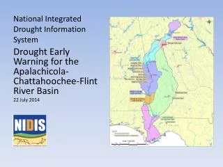
Coordinated reservoir operations: Low flow shortage triggering criteria (Powell/Mead) Inter-basin transfers Ecosystem health/services NIDIS Early Warning Systems Pilots – Drought-type and analysis unitsTailoring the drought portal to key regions Southeast
Kremmling Lake Powell Lake Mead
Assist in demand projections • Northern Water • Denver Water • Grand Valley • Assist USFWS in setting target flows • Peak enhancement • Late summer flows in 15-Mile Reach • Initiate drought mitigation discussions (e.g. Shoshone call reduction) (BoR Eastern CO Area office)
Drought monitor-U.S. Seasonal Drought Outlook Basin specifics • Insufficient number of high-elevation sites collecting weather and streamflow data • Tie global indices and signals (e.g., PDO, AMO, ENSO) to regional drought signals • How often are droughts on the west side of the divide “in-phase” with droughts on the east side? • NCWCD has no explicit triggers or formulas related to quota allocation • Potential fate of the UCRB snowpack in early March with respect to the degree that above-average temperatures and windy conditions in March and April might decrease the April-July forecasted runoff to Lake Powell • (NCWCD)
NIDIS Implementation Risk Assessment and Climate Research Opportunities/Challenges Coordinating federal, state, and local drought-related activities (e.g., within watersheds and states) Prediction Monitoring Applications Research Integrating Tools:e.g. Drought Portal Engaging preparedness communities: Indicators and management triggers ProactivePlanning ImprovedAdaptation ImpactMitigation
Upper Colorado River (down to Lake Mead) Pilot MeetingBoulder, CO, October 1 & 2, 2008 • Assessment study of gaps in monitoring, in process understanding, and in prediction • Gather and synthesize information from observation network operators, researchers, and forecasts/projection producers • Identify unmet needs for drought early warning • Provide the basis for initiatives to strengthen and enhance monitoring, understanding and prediction in support of drought early warning
Upper Colorado River Pilot Drought early warning client organizations convened from three categories: • Water managers from Reclamation and State governments of Utah, Wyoming, and Colorado • Urban/local water supply managers (Denver, Aurora, Northern Colorado Water Conservancy District) • Ecosystems/environmental/recreational resource managers (Forest Service, BLM, States, NPS, USGS/BRD, NGOs) • State and Federal climate researchers • Explore existing mandates, decision cycles, and organizational capacities to determine a team to implement the pilot
Four main topics emerged for near-term action: • Assessment of gaps in present monitoring and forecasting systems within the Basin • Assimilation of existing drought-related indicators, triggers and trends into one accessible location • Promoting interaction (existing websites, datasets) with the US Drought Portal to begin developing a Colorado Basin drought portal and information clearinghouse • Begin efforts to develop an Upper Colorado basin-specific drought monitor (including interbasin transfer locations and ecosystem impacts)
Develop small, focused teams led by the meeting participants (and others) beginning the design of the pilot early warning system. • Teams will begin to assess the role that improved coordination and access to such information could have played on planning and managing the impacts of previous events such as 2002, 1977 and multi-year events (and then for events selected from the paleoclimatic record and for projections of future changes relevant to water managers). • NIDIS Office will begin to work with the conservancies, urban, and federal entities on developing periodic discussions as key forecasting dates approach (most likely as part of existing water availability and management meetings)
Year 1: Designing a Drought Early Warning Information System • What exists. Gap analysis monitoring and forecasting • Key players-Existing planning processes • What partnerships and actions are needed (to improve information development, coordination and flow) • Year 2. Implementation of the Drought Early Warning System (across timescales from a season multi-year, longer term trends): • Improving coordination, feedback into “Colorado Basin” Drought Portal, ongoing briefings on impacts and projections across climate timescales • Years 3 and beyond : Early Warning System transferability and support
The combination of the inherent uncertainty of natural variability, plus projections for a warmer climate in the 21st century, make early warning and adaptation more important than ever • NIDIS offers a framework for integration and mainstreaming of vulnerability and hazard information to support adaptation strategies • NIDIS is viewed as a prototype for a National Climate Service
National Climate Service: Information services in support of adaptation RISAs, universities, and labs Integrating knowledge and products (CDC, ETL, RCCs, RFCs, SCs) Operational (RCCs, NCDC, CPC, WFOs, SCs, other private sector) RESEARCH & DEVELOPMENT & PROTOTYPING & SERVICES Regional Oversight and Evaluation OTHER NON-NOAA PARTNERS new or enhanced regional products information delivery technology sustained & systematic communication and feedback
Potential Opportunities/Challenges Risk Assessments vulnerabilities, triggers, decision making process, adaptive capacity, mitigation pathways, building/engaging network of users/partners Monitoring current and past temperature, precipitation, snowpack, soil moisture, runoff and evapotranspiration, and vegetation health trends/variations -- at all elevations Process critical thresholds, elevation dependency of climate Understanding change, closing the hydrologic budget, role of aerosols, role of sublimation, soil moisture sources and sinks, impacts of land use changes Modeling, Improved atmospheric/ hydrology coupling, Forecasts, extension of reliable predictions beyond 10 days Projections better seasonal outlooks + 2 to 5 year timescale, hydrologic demand predictions, downscaled projections to relevant elevation & spatial scales
The Cycle of Disaster Management NDMC and others
Where are we? • Interagency and Interstate NIDIS Team and Implementation Plan (June 07) • U.S. Drought Portal rollout (October 07) • Identify and review NOAA (and other) cross-line activities in support of NIDIS • (NIDIS Executive Council) • Satellite-based drought monitoring (Feb08), Climate projections over the Colorado Basin (Fall 07) • Designing drought early warning systems for the Southeast (ACF-ACF) April 08 • Planning meeting: Upper Colorado Basin (down to Lake Mead) • National Status of Drought Early Warning Systems (June 2008 Kansas City) • Upper Colorado Basin Workshop 1-2 October, 2008
Elements • 1. U.S. Drought Portal: • Development and tailoring • 2. Climate Test Beds: • Integrating data and forecasts • 3. Coping with Drought • Integrated Research and applications • Engaging preparedness communities • Education and awareness • 4. NIDIS EWS Pilots: • Early Warning System Design and Implementation • 5. NIDIS Program Office
Percent Change in Total Population, 1990-2000 5 1 4 3 2 Source: U.S. Geological Survey, National Atlas of the United States
Key issues • What climate and drought-related triggers are used for management and response seasonal operations, long-term planning (watershed, industry, state, county)? • How can we most effectively develop and coordinate information for early warning (onset, duration, demise, impacts) into drought plans? E.g. Exceptional Drought Operation Plan, Interim Operating Plan, Power needs etc? • Proposed NIDIS Pilot: Partnerships to maintain a regional dialog on drought, climate and water resources
Governance Structure for NIDIS Implementation NIDIS Executive Council Co-chairs: Director, NOAA Climate Program Office (or designee) Director, National Drought Mitigation Center (or designee) • NIDIS Program Office • (NPO Director) • Coordinate NIDIS-relevant cross-NOAA • and Interagency drought-related activities • Develop a national presence for NIDIS • (e.g. formal links to National Governors • Ass’n) • Participate in GEOSS / IEOS NIDIS Program Implementation Team (NPIT) Working-Level Partner Representatives Coordinate and develop evaluation criteria for all NIDIS activities including pilot project selection Chair: NPO Director NIDIS Technical Working Groups Federal, Regional, State, Tribal and Local Partner Leads Embedded in national and regional, and local NIDIS Activities Develop pilot implementation and transferability criteria Co-Chairs selected by NPIT National Integrated Drought Information System Drought Early Warning System Design, Pilots, and Implementation
In laymen’s terms there are 23 flushes left….. Atlanta Journal Constitution Oct. 2007
Governance Structure for NIDIS Implementation NIDIS Executive Council Co-chairs: Director, NOAA Climate Program Office (or designee) Director, National Drought Mitigation Center (or designee) NIDIS Program Implementation Team (NPIT) Working-Level Partner Representatives Coordinate and develop evaluation criteria for all NIDIS activities including pilot project selection Chair: NPO Director • NIDIS Program Office • (NPO Director) • Coordinate NIDIS-relevant cross-NOAA • and Interagency drought-related activities • Develop a national presence for NIDIS • (e.g. formal links to National Governors • Ass’n) • Participate in GEOSS / IEOS NIDIS Technical Working Groups Federal, Regional, State, Tribal and Local Partner Leads Embedded in national and regional, and local NIDIS Activities Develop pilot implementation and transferability criteria Co-Chairs selected by NPIT Public Awareness And Education U.S. Drought Portal Engaging Preparedness Communities Interdisciplinary Research and Applications Integrated Monitoring and Forecasting National Integrated Drought Information System Drought Early Warning System Design, Pilots, and Implementation
Spatial Resolution/ Time Horizon Operational Activity Decisions Operating Criteria and Guidelines Long-term Planning Basin-wide over decades Mid-term Operations Annual Operating Plan Basin-wide over 1-2 years Water and Power Schedules Sub-basin over 4-6 weeks Short-term Scheduling Unit Commitment Economic Dispatch Real-time Control Single project over 1-7 days Automatic Generation and Control (T. Fulp BoR)