Download
1 / 27
280 likes | 427 Views
DEVELOPING SPECIFICATIONS. Presented by Paul Quackenbush Paul.Quackenbush@gov.bc.ca Crown Registry and Geographic Base Integrated Land Management Bureau Government of British Columbia Victoria, B.C. Canada. Geographic Gateway. PRESENTATION CONTENT.

E N D
DEVELOPINGSPECIFICATIONS Presented by Paul Quackenbush Paul.Quackenbush@gov.bc.ca Crown Registry and Geographic Base Integrated Land Management Bureau Government of British Columbia Victoria, B.C. Canada
PRESENTATIONCONTENT Part I – Crown Registry and Geographic Base (CRGB) • Role of CRGB • Base Mapping Products • Governance Model for CRGB • Functional Model • CRGB Strategic Goals
ROLE OF CRGB • Stewards of Base Map data • Responsible for Geodetic framework • Sets standards and specifications for geospatial data • Business model changing from hands-on to oversight • Client service focus
Crown Registry & Geographic Base http://ilmbwww.gov.bc.ca/bmgs/pba/trim/specs BASE MAPPING PRODUCTShttp://ilmbwww.gov.bc.ca/bmgs
Assistant Deputy Minister responsible for GeoBC Provincial Base Mapping Advisory Committee (PBMAC) Communities of Practice CRGB Users, Clients, and Partners Crown Registry & Geographic Base Sources of Input: Geomatic Experts, Consultants, Clients, and Others GOVERNANCE MODEL
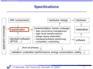
FUNCTIONAL MODEL Inventory Business Processes Data exchange arrangements Cost Recovery - Mountain Pine Beetle (MPB) Forest for Tomorrow (FFT) As Built Roads (ABR) & Electronic Petroleum Application Spatial Submission (EPASS) Technology Satellite – Eye in the Sky Global Positioning System (GPS) Light Detection and Ranging (LIDAR) Digital Camera Digital Elevation Model Place Names Planimetry (Roads/Rivers / Lakes / Coastline) Air photos Rectified Imagery Infrastructure TRIM databaseBC Active Control System
BMGS STRATEGIC GOALS • Clients achieve their objectives through convenient access to integrated information • Clients receive base mapping that meets their needs in terms of core features and update cycles • Further the use and integration of provincial base mapping in all sectors of the economy • Clients engage CRGB as a Center of Excellence for geomatic technology • Development of Specifications and the Community of Practice responds to goals through: • working with stakeholders to identify business requirements & strategies • piloting update process • evaluating results • making proposals for changes
PRESENTATIONCONTENT Part II – Specifications Development • Areas of activity • Why were specifications required • What was required in the specification content • Approach used for development of specifications • Where Crown Registry & Geographic Base is at • Next steps
AREAS OF ACTIVITY • Medium Format Digital cameras • LiDAR • Aerial Triangulation (A/T) • Orthophotos
SPECIFICATIONS – Please ! Why were specifications required? • New, emerging technologies were seen as viable tools • Medium format digital cameras • LiDAR • Soft copy A/T, auto correlation and INS/IMU • Clients wanted faster end to end turn around • Promising tools but technical issues • CRGB – needed to establish leadership to avoid random adoption • Change focus to resultsas opposed to prescriptive process
SPECIFICATIONS CONTENT What was required in the specification content? • Clearly defined deliverables for: • Digital air photo and Orthophotos • LiDAR • A/T • Standards for calibration of: • non-metric cameras • LiDAR calibration • Q/A – Q/C processes • A software packages that are readily available to all contractors • Meta Data standards
LiDAR SPECIFICATIONS CONTENT Specifics for the LiDAR specification content • LiDAR is not an “open” system” – required a different approach • A simple means of determining potential system accuracy through error propagation formula • Use material from others – FEMA, ASPRS, USGS • Define a QA/QC process • Require calibration and reports • Require data processing methodologies
DEVELOPING SPECIFICATIONS Approach used to develop specifications • Community of Practice (CoPs) • Building “buy-in” • Engage academia, clients, producers and data custodians • Build operational specifications • Move research from academia into industry • Specifications development from a project manager perspective • Create environment of shared knowledge and cooperation
DEVELOPING SPECIFICATIONS Approach used to develop specifications • Community of Practice (CoPs) • Building “buy-in” • Engage academia, clients, producers and data custodians • Build operational specifications • Move research from academia into industry • Create environment of shared knowledge and cooperation TheCommunity of Practiceis made up of academia, data producers , consulting community and clients
Where is CRGB currently? Where Crown Registry and Geographic Base is at • Specifications completion status: • Med. Format Digital Camera (MFDC) published • LiDAR published • A/T published • Pilot projects • An area was flown using the draft specifications for MFDC • LiDAR– now using some test data • Multiple A/T testing using expert knowledge
NEXT STEPS What are the Next Steps? • Continue the Communities of Practice • Continue development/evolution of the specifications • Address colour chip issues
NEXT STEPS Colour Range is very subjective, So which image would best serve the multi-use needs of Clients.
NEXT STEPS What are the Next Steps? • Continue the Community of Practice • Continue development/evolution of the specifications • Address colour chip issues • Integrate digital and film specifications • Simplify and consolidate result based specifications (non-prescriptive) • Continue to evaluate performance and specification requirements • Continue to work with clients to meet their needs • Address large format digital camera issues
NEXT STEPS What is the definition of a Large Format Camera? Large Format Camera The Large Format Camera (LFC) was a high altitude aerial mapping camera scaled up to operate from the Space Shuttle. It was used on one mission in October 1984 The camera weighs about half a ton and a single frame covers 23,400 square miles at about 10-20 m resolution.
NEXT STEPS What are the Next Steps? • Continue the Community of Practice • Continue development/evolution of the specifications • Address colour chip issues • Integrate digital and film specifications • Simplify and consolidate result based specifications (non-prescriptive) • Continue to evaluate performance and specification requirements • Continue to work with clients to meet their needs • Address large format digital camera issues • Further work on in-situ calibration sites
ACTIVITIES • Calibration wall • In-situ calibration site • External agreements for calibration (BCIT) • Continuation of Community of Practice • Continue to seek external partnerships and cooperation (University of Calgary, USGS,…)
# of Users & target Audience Cost & Training commitment Focus of Interviews Focus of Web survey Tool Tier Functionality Tier One Biologists Forestry Officers Research Officers Non-technical Staff IMapBC IMF applns View Query Plot $ (Web) Tier Two $$ Terminal Server Analysis Tools Professional Staff trained in GIS needing additional functionality Custom Maps Simple Analyses Complex Queries (ArcView) $$$$ Tier Three Modeling & Analysis GIS Analysis Analysis (ArcInfo) And the Survey said
QUESTIONS Questions Thank-you