Download
1 / 23
230 likes | 357 Views
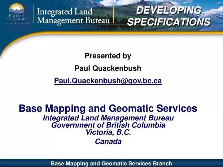
DEVELOPING SPECIFICATIONS. Presented by Paul Quackenbush Paul.Quackenbush@gov.bc.ca Base Mapping and Geomatic Services Integrated Land Management Bureau Government of British Columbia Victoria, B.C. Canada. PRESENTATION CONTENT. Part I – Base Mapping and Geomatic Services (BMGS)

E N D
DEVELOPINGSPECIFICATIONS Presented by Paul Quackenbush Paul.Quackenbush@gov.bc.ca Base Mapping and Geomatic Services Integrated Land Management Bureau Government of British Columbia Victoria, B.C. Canada Base Mapping and Geomatic Services Branch
PRESENTATIONCONTENT Part I – Base Mapping and Geomatic Services (BMGS) • Role of BMGS • Base Mapping Products • Governance Model for BMGS • Functional Model • BMGS Strategic Goals Base Mapping and Geomatic Services Branch
ROLE OF BMGS • Stewards of Base Map data • Responsible for Geodetic framework • Sets standards and specifications for geospatial data • Business model changing from hands-on to oversight • Client service focus Base Mapping and Geomatic Services Branch
BASE MAPPING PRODUCTShttp://ilmbwww.gov.bc.ca/bmgs http://ilmbwww.gov.bc.ca/bmgs/pba/trim/specs Base Mapping and Geomatic Services Branch
Assistant Deputy Minister responsible for Corporate Resource Information Management Provincial Base Mapping Advisory Committee (PBMAC) Communities of Practice BMGS Users, Clients, and Partners Base Mapping & Geomatic Services Branch Sources of Input: Geomatics Experts, Consultants, Clients, and Others GOVERNANCE MODEL Base Mapping and Geomatic Services Branch
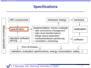
FUNCTIONAL MODEL Inventory Business Processes Data exchange arrangements Cost Recovery - Mountain Pine Beetle (MPB) Forest for Tomorrow (FFT) As Built Roads (ABR) & Electronic Petroleum Application Spatial Submission (EPASS) Technology Satellite – Eye in the Sky Global Positioning System (GPS) Light Detection and Ranging (LIDAR) Digital Camera Digital Elevation Model Place Names Planimetry (Roads/Rivers / Lakes / Coastline) Air photos Rectified Imagery Infrastructure TRIM databaseBC Active Control System Base Mapping and Geomatic Services Branch
Clients achieve their objectives through convenient access to integrated information Clients receive base mapping that meets their needs in terms of core features and update cycles Further the use and integration of provincial base mapping in all sectors of the economy Clients engage BMGS as a Center of Excellence for geomatic technology BMGS STRATEGIC GOALS • Development of Specifications and the Community of Practice responds to goals through: • working with stakeholders to identify business requirements & strategies • piloting update process • evaluating results • making proposals for changes Base Mapping and Geomatic Services Branch
PRESENTATIONCONTENT Part II – Specifications Development • Areas of activity • Why were specifications required • What was required in the specification content • Approach used for development of specifications • Where Base Mapping and Geomatic Services is at • Next steps Base Mapping and Geomatic Services Branch
AREAS OF ACTIVITY • Medium Format Digital cameras • LiDAR • Aerial Triangulation (A/T) • Orthophotos Base Mapping and Geomatic Services Branch
SPECIFICATIONS – Please ! Why were specifications required? • New, emerging technologies were seen as viable tools • Medium format digital cameras • LiDAR • Soft copy A/T, auto correlation and INS/IMU • Clients wanted faster end to end turn around • Promising tools but technical issues • BMGS – needed to establish leadership to avoid random adoption • Change focus to resultsas opposed to prescriptive process Base Mapping and Geomatic Services Branch
SPECIFICATIONS CONTENT What was required in the specification content? • Clearly defined deliverables for: • Digital air photo and Orthophotos • LiDAR • A/T • Standards for calibration of: • non-metric cameras • LiDAR calibration • Q/A – Q/C processes • A software packages that are readily available to all contractors • Meta Data standards Base Mapping and Geomatic Services Branch
LiDAR SPECIFICATIONS CONTENT Specifics for the LiDAR specification content • LiDAR is not an “open” system” – required a different approach • A simple means of determining potential system accuracy through error propagation formula • Use material from others – FEMA, ASPRS, USGS • Define a QA/QC process • Require calibration and reports • Require data processing methodologies Base Mapping and Geomatic Services Branch
DEVELOPING SPECIFICATIONS Approach used to develop specifications • Community of Practice (CoPs) • Building “buy-in” • Engage academia, clients, producers and data custodians • Build operational specifications • Move research from academia into industry • Specifications development from a project manager perspective • Create environment of shared knowledge and cooperation Definition Base Mapping and Geomatic Services Branch
DEVELOPING SPECIFICATIONS Approach used to develop specifications • Community of Practice (CoPs) • Building “buy-in” • Engage academia, clients, producers and data custodians • Build operational specifications • Move research from academia into industry • Create environment of shared knowledge and cooperation TheCommunity of Practiceis made up of academia, data producers , consulting community and clients Base Mapping and Geomatic Services Branch
Where is BMGS currently? Where Base Mapping and Geomatic Services is at • Specifications completion status: • Med. Format Digital Camera (MFDC) published • LiDAR published • A/T published • Pilot projects • An area was flown using the draft specifications for MFDC • LiDAR– now using some test data • Multiple A/T testing using expert knowledge Base Mapping and Geomatic Services Branch
NEXT STEPS Base Mapping and Geomatic Services Branch
NEXT STEPS Base Mapping and Geomatic Services Branch
NEXT STEPS Colour Range is very subjective, So which image would best serve the multi-use needs of Clients. Base Mapping and Geomatic Services Branch
NEXT STEPS What are the Next Steps? • Continue the Community of Practice • Address colour chip issues • Integrate digital and film specifications • Simplify and consolidate • Continue to evaluate performance and specification requirements • Continue to work with clients to meet their needs Base Mapping and Geomatic Services Branch
NEXT STEPS What is the definition of a Large Format Camera? Large Format Camera The Large Format Camera (LFC) was a high altitude aerial mapping camera scaled up to operate from the Space Shuttle. It was used on one mission in October 1984 The camera weighs about half a ton and a single frame covers 23,400 square miles at about 10-20 m resolution. Base Mapping and Geomatic Services Branch
NEXT STEPS What are the Next Steps? • Continue the Community of Practice • Address colour chip issues • Integrate digital and film specifications • Simplify and consolidate • Address large format digital camera issues • Further work on in-situ calibration sites Base Mapping and Geomatic Services Branch
ACTIVITIES • Calibration wall • In-situ calibration site • External agreements for calibration (BCIT) • Continuation of Community of Practice • Continue to seek external partnerships and cooperation (University of Calgary, USGS, …) Base Mapping and Geomatic Services Branch
QUESTIONS Questions Thank-you Base Mapping and Geomatic Services Branch