Download
1 / 1
10 likes | 82 Views
Seismic Hazards in the Klamath Falls Area. Prepared By Gretchen Boyer, ES 473 Environmental Geology, Spring 2009. SEISMIC MONITORING. KLAMATH FALLS EARTHQUAKES. INTRODUCTION. ABSTRACT.

E N D
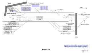
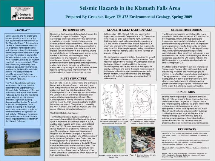
Seismic Hazards in the Klamath Falls Area Prepared By Gretchen Boyer, ES 473 Environmental Geology, Spring 2009 SEISMIC MONITORING KLAMATH FALLS EARTHQUAKES INTRODUCTION ABSTRACT Because of its dynamic underlying fault structure, the Klamath Falls region in Southern Oregon experiences unique seismic activity that comes with a multitude of potential hazards that pose many different types of threats to residents. Inhabitants and local government are faced with the daunting task of preparing for earthquakes that can be sporadic and that can vary in intensity from mild to severe. Due to its multiple faults, an earthquake could happen in any number of locations, so seismologists keep a watchful eye for any indication of seismic disturbances. Klamath Falls does have a slight potential for volcanic earthquakes up to magnitude 5, and an even smaller potential for a Cascadia earthquake of up to magnitude 8-9, however, shallow tectonic earthquakes are more common in the region and are of the most immediate concern. In September 1993, Klamath Falls was struck by the largest earthquake to hit Oregon since 1873. The quakes were felt as far away Eugene to the north, and Chico, California to the south. A foreshock had a magnitude of 3.9, and the first of the two main shocks registered 5.9, which was followed by the largest shock that registered a magnitude 6.0. A few people reported feeling intensities of VII on the Mercalli Intensity Scale, but most reported an intensity of about VI. The earthquakes caused landslides throughout an area of about 162 square miles surrounding the epicenter. One rock slide occurred near highway 97 and crashed through the barrier, hitting a vehicle and killing the driver. The earthquakes also caused extensive damage to the county courthouse and over a thousand residences and businesses suffered damages involving cracked walls, broken windows, collapsed chimneys, and damaged plumbing. All totaled, the damage was upwards of 10 million dollars. The Klamath earthquakes were followed by many aftershocks: by October, more than 400 that had had been recorded. Initially, individual earthquake hypocenters were poorly located due to a lack of permanent seismographs in the area, so 20 portable seismographs were rapidly deployed by from local Universities. By October, the U.S. Geological Survey installed four permanent seismographs in the epicentral region. Data from these instruments is now telemetered to the University of Washington, where it is recorded as part of the UW seismic network. The UW is now able to precisely locate aftershocks as small as magnitude 0.3. In addition to the 3 “sensitive” stations, There is one "strong motion"station, KFAL at Klamath Falls, and that will stay "on scale" and record large ground motions in high fidelity in case of a large earthquake. This equipment won't allow scientists to “predict” earthquakes, but it does allow them to keep a very close eye on fault movement, which allows for a greater understanding of slip and fault displacement in the region that ultimately cause earthquakes. Mount Mazama and the Crater Lake caldera lies at the north end of the fault bounded basin that is known as the “Klamath Graben”. This structural low lies at the northwestern end of a set of complex northwest-trending fault-block mountains, located on the western edge of the Basin and Range province. The graben is bounded on the west and east sides by the active West Klamath Lake and East Klamath Lake fault zones, respectively. While both of the margin-bounding fault zones are active, there is more data available for the West Klamath Lake portion. This data provides the scientific framework that allows understanding of seismic hazards in the Klamath Falls area. The West Klamath lake fault zone terminates to the south, near the epicenter of the September 1993 “Klamath Falls Earthquakes.” The two main shocks that struck the Klamath Falls area during that time registered magnitudes 5.9 and 6.0, causing landslides, significant building damage and two deaths. As a result of the 1993 earthquakes, closer seismic monitoring of the Klamath region was implemented in order to better understand the dynamics of fault activity. This paper focuses on earthquake mechanics and hazards monitoring programs associated with the Klamath Falls area. FAULT STRUCTURE Klamath Falls lies on a series of faults and a structure known as the Klamath Graben. Horst and graben refer to regions that lie between normal faults, and a graben is a block that has dropped down. The Klamath graben is one of the major structures within the Cascades Basin and Range transgression of northern California and southern Oregon. The Klamath graben is moving towards the northwest, where it meets the High Cascades volcanic arc that is trending north-south. The graben is bounded by the West Klamath Lake and East Klamath lake fault zones, which are both seismically active. West Klamath Lake Fault Zone The West Klamath Lake fault zone (WKLFZ) is composed of several individual faults with lengths of up to 15 kilometers an an overall length of 60 km, and has been mapped up to Crater Lake National Park. The WKLFZ faults trend north south, and shows displacement of about 0.3 millimeters per year. The consistency in age and displacement suggests that the WKLFZ merges at depth into a single through going structure. One of the constituent faults, the Annie Spring fault, near Crater Lake has been responsible for a few minor earthquakes, however, the Southern boundary of the WKLFZ has historically been the site of more earthquakes. This region is marked by a change in strike faults from north to north-northwest near the Epicenter of the 1993 Klamath Falls earthquakes, which registered as high as magnitude 6. CONCLUSION Seismic monitoring and public education efforts in Klamath Falls are ongoing. Some progress has been made by enacting a dangerous building ordinance and retrofitting some buildings, but efforts will need to continue in order to be prepared for future earthquakes. A recent state report found that many Klamath county schools and public safety buildings could collapse during a large earthquake. Voters recently defeated a 20 million dollar bond that included seismic upgrades. Seismologists closely monitor Klamath falls, but residents must also prepare and educate themselves about earthquakes. Figure 1: Map showing Faults active in the past few million years and earthquake epicenters through September 1997. Figure 2: Isoseismal map indicating the combined effects of the two strongest quakes on September 20th, 1993. REFERENCES 1.Bacon, C.R, 1997, Volcano and Earthquake Hazards in the Crater Lake Region, Oregon: U.S Department of the Interior, U.S Geological Survey. 2.Bacon, C.R, 1999, Late Quaternary Slip Rate and Seismic Hazard of the West Klamath Lake Fault Zone near Crater Lake, Oregon Cascades: Geology, Volume 27, no. 1, p.43-46. 3.Beach, L., 2007, Schools Will Not Withstand Earthquake, Herald and News: 4.Wiley, T.A et al., 1993, Klamath Falls Earthquakes. September 20th 1993 – Including the Strongest Quake ever measured in Oregon: Oregon Geology, Volume 55 Number 6. Figure 4: Structural damage during the 1993 earthquakes. Figure 3: Location of Seismic Stations Near Klamath Falls.