Download
1 / 19
190 likes | 281 Views
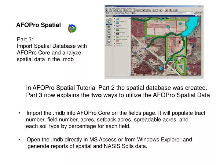
AFOPro Spatial. Part 3: Import Spatial Database with AFOPro Core and analyze spatial data in the .mdb. In AFOPro Spatial Tutorial Part 2 the spatial database was created. Part 3 now explains the two ways to utilize the AFOPro Spatial Data.

E N D
AFOPro Spatial Part 3: Import Spatial Database with AFOPro Core and analyze spatial data in the .mdb In AFOPro Spatial Tutorial Part 2 the spatial database was created. Part 3 now explains the two ways to utilize the AFOPro Spatial Data • Import the .mdb into AFOPro Core on the fields page. It will populate tract • number, field number, acres, setback acres, spreadable acres, and • each soil type by percentage for each field. • Open the .mdb directly in MS Access or from Windows Explorer and • generate reports of spatial and NASIS Soils data.
Spatial Data Prep: Step 8 Import the AFOPro Spatial .mdb into AFOPro Core To import the data into AFOPro Core... 1. Open the application
Spatial Data Prep: Step 8 Import the AFOPro Spatial .mdb into AFOPro Core To import the data into AFOPro Core... 2. Select New Operation or Existing Operation
Spatial Data Prep: Step 8 Import the AFOPro Spatial .mdb into AFOPro Core To import the data into AFOPro Core... 3. Populate the Operation Page if it is a New Operation. If it is Existing go to step 4. Note: Operation Name, State, Plan Name, and Planning Start and End Dates are required fields
Spatial Data Prep: Step 8 Import the AFOPro Spatial .mdb into AFOPro Core To import the data into AFOPro Core... 4. Go to the Fields Page by clicking on the Fields tab
Spatial Data Prep: Step 8 Import the AFOPro Spatial .mdb into AFOPro Core To import the data into AFOPro Core... 4. Go to the Fields Page by clicking on the Fields tab
Spatial Data Prep: Step 8 Import the AFOPro Spatial .mdb into AFOPro Core To import the data into AFOPro Core... 5. Click the Import Field Button
Spatial Data Prep: Step 8 Import the AFOPro Spatial .mdb into AFOPro Core To import the data into AFOPro Core... 6. Choose which application was used to prepare spatial data
Spatial Data Prep: Step 8 Import the AFOPro Spatial .mdb into AFOPro Core AFOPro has successfully imported the spatial data Tract and Field Numbers
Spatial Data Prep: Step 8 Import the AFOPro Spatial .mdb into AFOPro Core AFOPro has successfully imported the spatial data Soil Symbols and Percentage of Field
Spatial Data Prep: Step 8 Import the AFOPro Spatial .mdb into AFOPro Core AFOPro has successfully imported the spatial data Land Use, Acreage, Buffer Acreage, and Spreadable Acreage
Spatial Data Prep: Step 9 Open the AFOPro Spatial .mdb and Create Reports Browse to the spatial database that was exported from AFOPro Spatial and open it with MS Access
Spatial Data Prep: Step 9 Open the AFOPro Spatial .mdb and Create Reports Many reports have been created for the user.
Spatial Data Prep: Step 9 Open the AFOPro Spatial .mdb and Create Reports Reports from NASIS Database of soil types that intersect the Planned Land Units theme
Spatial Data Prep: Step 9 Open the AFOPro Spatial .mdb and Create Reports Reports based on fields from Planned Land Units theme in ArcView
Spatial Data Prep: Step 9 Open the AFOPro Spatial .mdb and Create Reports Once reports have been previewed the information that they contain may be printed or exported to Word or Excel for further formatting.
Spatial Data Prep: Step 9 Open the AFOPro Spatial .mdb and Create Reports The Access Tables and Queries used by AFOPro Spatial have been left unhidden for users who would like to produce custom reports with the data.
For Additional Information, Interest in AFOPro for your State, or Technical Assistance • Contact • Mark Evans • 803-777-7600 • mevans@esri.sc.edu • Wes Standish • 803-777-7600 • standish@esri.sc.edu • Visit (To Download AFOPro) • http://www.esri.sc.edu/Projects/usda/application_development/afopro.asp