Download
1 / 21
210 likes | 330 Views
Nicaragua. Active fires from the FAO’s Global Fire Information Management System (GFIMS). http://www.fao.org/nr/gfims/ [GFIMS home ]. http://rapidfire.sci.gsfc.nasa.gov/ [MODIS Rapid Response System]. http://modis.gsfc.nasa.gov/ [MODIS Web ]. 2001-2012. Nicaragua. Active Fires

E N D
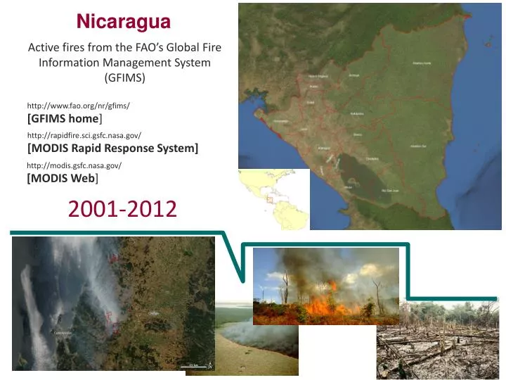
Nicaragua Active fires from the FAO’s Global Fire Information Management System (GFIMS) http://www.fao.org/nr/gfims/ [GFIMS home] http://rapidfire.sci.gsfc.nasa.gov/ [MODIS Rapid Response System] http://modis.gsfc.nasa.gov/ [MODIS Web] 2001-2012
Nicaragua Active Fires frequency by month/year The designations employed and the presentation of material in the map(s) do not imply the expression of any opinion whatsoever on the part of FAO concerning the legal or constitutional status of any country, territory or sea area, or concerning the delimitation of frontiers. The graph depicts the year with the highest Active fire count which is Year 2005 with 6,888 fire counts; while the year with the lowest active fire count was Year 2007 with 2,739 with an average active fire count of 4,371. Note that the Terra and Aqua satellites were launched the18 December 1999 and 4 May 2002, respectively. Data between 2001 and 2011 are part of the Collection 5 (reprocessed by better algorithm compared to Collection 4), while 2012 is Collection 4. Browse the GFIMS website for more details. 2001-2011 data source: GIFIMS’s Firemap
Nicaragua The designations employed and the presentation of material in the map(s) do not imply the expression of any opinion whatsoever on the part of FAO concerning the legal or constitutional status of any country, territory or sea area, or concerning the delimitation of frontiers. Active Fires active fire season (2001-2011) Active fires 2005 (6,888 fires) The active fire season starts in December until June, mostly peaking in April
Nicaragua The designations employed and the presentation of material in the map(s) do not imply the expression of any opinion whatsoever on the part of FAO concerning the legal or constitutional status of any country, territory or sea area, or concerning the delimitation of frontiers. Active Fires Inter Annual Variability of Fires 2001-2011 The graph shows active fires peaks without ‘trough months’ (months with low fire counts) in the period 2001-2011. The fire season extends mostly between December and June. All seasonal fires peaked in November in which most fires occur.
Nicaragua Active Fires frequency by Province/year 2001-2011 data source: GIFIMS’s Firemap
Nicaragua Active Fires frequency by Land Cover, 2001-2012 [Globcover (regional) 2005] http://ionia1.esrin.esa.int/ [European Space Agency, ESA]
Nicaragua Active Fires frequency by Land Cover, 2001-2012 [Globcover (regional) 2005] Fires 2001-2012 Globcover 2005
Nicaragua Active Fires frequency by Land Cover, 2001-2012 [Globcover (global) 2009] http://ionia1.esrin.esa.int/ [European Space Agency, ESA]
Nicaragua Active fires and burned areas from the FAO’s Global Fire Information Management System (GFIMS) http://www.fao.org/nr/gfims/ [GFIMS home] http://rapidfire.sci.gsfc.nasa.gov/ [MODIS Rapid Response System] http://modis.gsfc.nasa.gov/ [MODIS Web] Maps
Nicaragua The designations employed and the presentation of material in the map(s) do not imply the expression of any opinion whatsoever on the part of FAO concerning the legal or constitutional status of any country, territory or sea area, or concerning the delimitation of frontiers. http://www.fao.org/nr/gfims/ [GFIMS home] active fires 2001
Nicaragua The designations employed and the presentation of material in the map(s) do not imply the expression of any opinion whatsoever on the part of FAO concerning the legal or constitutional status of any country, territory or sea area, or concerning the delimitation of frontiers. http://www.fao.org/nr/gfims/ [GFIMS home] active fires 2002
Nicaragua The designations employed and the presentation of material in the map(s) do not imply the expression of any opinion whatsoever on the part of FAO concerning the legal or constitutional status of any country, territory or sea area, or concerning the delimitation of frontiers. http://www.fao.org/nr/gfims/ [GFIMS home] active fires 2003
Nicaragua The designations employed and the presentation of material in the map(s) do not imply the expression of any opinion whatsoever on the part of FAO concerning the legal or constitutional status of any country, territory or sea area, or concerning the delimitation of frontiers. http://www.fao.org/nr/gfims/ [GFIMS home] active fires 2004
Nicaragua The designations employed and the presentation of material in the map(s) do not imply the expression of any opinion whatsoever on the part of FAO concerning the legal or constitutional status of any country, territory or sea area, or concerning the delimitation of frontiers. http://www.fao.org/nr/gfims/ [GFIMS home] active fires 2005
Nicaragua The designations employed and the presentation of material in the map(s) do not imply the expression of any opinion whatsoever on the part of FAO concerning the legal or constitutional status of any country, territory or sea area, or concerning the delimitation of frontiers. http://www.fao.org/nr/gfims/ [GFIMS home] active fires 2006
Nicaragua The designations employed and the presentation of material in the map(s) do not imply the expression of any opinion whatsoever on the part of FAO concerning the legal or constitutional status of any country, territory or sea area, or concerning the delimitation of frontiers. http://www.fao.org/nr/gfims/ [GFIMS home] active fires 2007
Nicaragua The designations employed and the presentation of material in the map(s) do not imply the expression of any opinion whatsoever on the part of FAO concerning the legal or constitutional status of any country, territory or sea area, or concerning the delimitation of frontiers. http://www.fao.org/nr/gfims/ [GFIMS home] active fires 2008
Nicaragua The designations employed and the presentation of material in the map(s) do not imply the expression of any opinion whatsoever on the part of FAO concerning the legal or constitutional status of any country, territory or sea area, or concerning the delimitation of frontiers. http://www.fao.org/nr/gfims/ [GFIMS home] active fires 2009
Nicaragua The designations employed and the presentation of material in the map(s) do not imply the expression of any opinion whatsoever on the part of FAO concerning the legal or constitutional status of any country, territory or sea area, or concerning the delimitation of frontiers. http://www.fao.org/nr/gfims/ [GFIMS home] active fires 2010
Nicaragua The designations employed and the presentation of material in the map(s) do not imply the expression of any opinion whatsoever on the part of FAO concerning the legal or constitutional status of any country, territory or sea area, or concerning the delimitation of frontiers. http://www.fao.org/nr/gfims/ [GFIMS home] active fires 2011
Nicaragua The designations employed and the presentation of material in the map(s) do not imply the expression of any opinion whatsoever on the part of FAO concerning the legal or constitutional status of any country, territory or sea area, or concerning the delimitation of frontiers. http://www.fao.org/nr/gfims/ [GFIMS home] active fires 2012