Download
1 / 6
60 likes | 64 Views
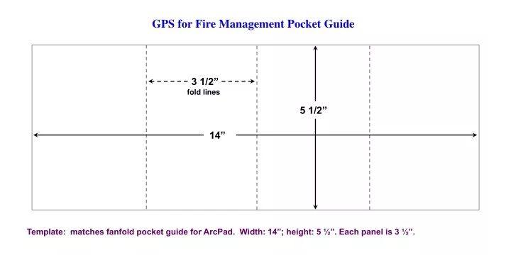
GPS for Fire Management Pocket Guide. 3 1/2”. fold lines. 5 1/2”. 14”. Template: matches fanfold pocket guide for ArcPad. Width: 14”; height: 5 ½”. Each panel is 3 ½”. Template. Fold line. Gutters. Print margin.

E N D
GPS for Fire Management Pocket Guide 3 1/2” fold lines 5 1/2” 14” Template: matches fanfold pocket guide for ArcPad. Width: 14”; height: 5 ½”. Each panel is 3 ½”.
Template Fold line Gutters Print margin Template: Width: 14”; height: 5 ½”. Each panel is 3 ½”.Gutters: ¼” (red lines). Fold lines in dashes. Inside margins: 1/4” (extent of text – red lines). Font: Arial, 10 pt. Headers in bold.
Receiver Operation Datum GPS III Plus Main Pages Button Function Receiver Setup Download Almanac Front Side GPS for Fire Management PocketReference for the Garmin GPS III Plus Setup Page Use Setup page to customize the way page information and data is displayed. • When there is a change in datum, coordinate values change for all points on the ground. • If using GPS receiver with a map, match receiver datum to map datum. • If using position or waypoint coordinates from other sources, match the receiver datum to the datum those coordinates were derived in prior to inputting the coordinates into the receiver. Page Options Menu Within any page, press Menu button once to open page options menu unique to that page. MENU Map Page Front Press Menu button once to open Map Setup. Set map display preferences as desired. Download a new almanac if GPS receiver is new, has been moved more than 300 miles while turned off, or has not been used within the last 30 days. Turn receiver on and place in location with clear view of sky. Allow 12 to 15 minutes for a new almanac to download after receiver acquires first satellite signal. The almanac is automatically updated whenever receiver is in use. Up to four data fields may be displayed at one time. Select Change Fields to change or hide (enlarges map) data fields. Main Menu Compass Page Press Menu button once to open Compass Setup menu. MENU From any page, press Menu button twice. Satellite Status Page Collect points and tracks in 3D Navigation mode. Monitor battery power, EPE and DOP during mission to ensure data quality. To set up receiver, toggle to Setup, press Enter button once. This pocket reference is a supplement to the GPS for Fire Management Course 2004. Garmin is a registered trademark of Garmin International. Set compass orientation in Setup Page, Units tab, Heading. ENTER MARK
Create Averaged Position Waypoint Create Waypoint Waypoint Setup Track Log Setup Mission Checklist Collect Track Log Back Side Display Orientation Set Interval to Time. Set Interval Value based on method of travel during data collection, and size of area to be mapped. A total of 1900 track points are available in Log. Press and hold Page button to switch landscape or portrait orientation. Mark waypoint. Name waypoint if needed. Do not edit Comment field. Press Menu button once to open Waypoint Options page. • Briefing • Plan mission to achieve the objectives. • Logistics defined to execute and complete mission. • Delivered data/product format understood. • Equipment • GPS receiver. Is a backup receiver advisable? • Proper cables and external attachments. • External antenna. • Adequate batteries or power source. • Paper map and compass. • Notebook and pencil. • Metadata form and/or notepad. • Prepare GPS receiver • Set datum, coordinate system, display and time format. • Download or delete old waypoints if not needed. • Tracks – download or delete old tracks. • Set up Track Log collection interval based on method of travel and size of area to be mapped. • Check wires and connections. • Updated receiver almanac for local area. • Aerial mapping mission • Avoid having to repeat the mission by: • Briefing pilot on mission prior to takeoff. • Ensuring reliable external antenna connection. • Carrying spare GPS receiver and batteries. PAGE Approximate log times (start with empty Active Log): One second Interval Value: 31 minutes total log time Two second Interval Value: 63 minutes total log time Three second Interval Time: 95 minutes total log time Five second Interval Value: 2.6 hours total log time Suggested logging rates (adjust as needed): Helicopter: 1 - 3 second log interval Walking: 5 - 10 second log interval Vehicle: 3 - 5 second log interval Select Average Position and press Enter button once. Measurement Count begins automatically. Note Measurement From Main Menu, select Waypoints. Press Menu button to open page. Press Menu button again to display Waypoints options menu. Back Count for each waypoint on metadata form. Select and press Save when done. Averaged positions will be saved as a single waypoint. MENU To start collecting a track log, set Record Mode to Fill. Press Enter button to start logging positions. Do not select Wrap. To pause logging, set Record Mode to Off. When mission is complete, turn GPS receiver off. Do not Save Active Log as the number of collected track points will be greatly reduced to conserve memory. Active Log page displays percentage of From Main Menu, select Track Logs. Press Menu button to open Track Log Menu. Press and hold Enter/Mark button to create new waypoint. ENTER MARK Clear, or download and clear Active Log to free up memory. Select Clear Active Log. Select Setup Logging. Press Enter button once. Set Record Mode to Off. Do not edit Comment field (this information is needed for GIS). Select Done and press Enter button to save waypoint. memory used. Monitor percentage used to ensure adequate free memory to complete the mission.
Receiver Operation Datum Wildfire Waypoint Codes Button Function Receiver Setup Download Almanac Front Side – 2 Waypoint Codes GPS for Fire Management PocketReference for the Garmin GPS III Plus Setup Page Use Setup page to customize the way page information and data is displayed. AS Accident Site MV Medivac Site CA Camp OP Observation Point BR Bridge PR Protected Resource DB Division Break RH Rehab Site*** DP Drop Point RJ Road Junction DL Dozer Line RS Radio Site FL Fire Line* SA Staging Area GT Gate FO Fire Origin HA Hazard** SC Stream Crossing HB Helibase SF Spot Fire HS Helispot ST Structure IC ICP SZ Safety Zone MP Milepost IR Infrared Hotspot WS Water Source *B – Blasted, D – Dozer, H – Hand **M – Mine Shaft, S – Snag, W – Well ***F – Fence, R – Road, W – Water Example: “DBXY” = X – Y Division Break • When there is a change in datum, coordinate values change for all points on the ground. • If using GPS receiver with a map, match receiver datum to map datum. • If using position or waypoint coordinates from other sources, match the receiver datum to the datum those coordinates were derived in prior to inputting the coordinates into the receiver. Page Options Menu Within any page, press Menu button once to open page options menu unique to that page. MENU Map Page Front Press Menu button once to open Map Setup. Set map display preferences as desired. Download a new almanac if GPS receiver is new, has been moved more than 300 miles while turned off, or has not been used within the last 30 days. Turn receiver on and place in location with clear view of sky. Allow 12 to 15 minutes for a new almanac to download after receiver acquires first satellite signal. The almanac is automatically updated whenever receiver is in use. Up to four data fields may be displayed at one time. Select Change Fields to change or hide (enlarges map) data fields. Compass Page Main Menu Press Menu button once to open Compass Setup menu. MENU From any page, press Menu button twice. Satellite Status Page Collect points and tracks in 3D Navigation mode. Monitor battery power, EPE and DOP during mission to ensure data quality. To set up receiver, toggle to Setup, press Enter button once. This pocket reference is a supplement to the GPS for Fire Management Course 2004. Garmin is a registered trademark of Garmin International. Set compass orientation in Setup Page, Units tab, Heading. ENTER MARK