Download
1 / 14
150 likes | 353 Views
Sea Surface Topography and Mass Transport of the Antarctic Circumpolar Current Jens Schröter, Reiner Rummel, Wolfgang Bosch, Sergey Skachko, Alberta Albertella and Roman Savcenko DFG SPP 1257 Project: GEOTOP Meerestopographie und Massentransporte in Zirkumpolarstrom und Weddellwirbel.

E N D
Sea Surface Topography and Mass Transport of the Antarctic Circumpolar Current Jens Schröter, Reiner Rummel, Wolfgang Bosch, Sergey Skachko, Alberta Albertella and Roman Savcenko DFG SPP 1257 Project: GEOTOP Meerestopographie und Massentransporte in Zirkumpolarstrom und Weddellwirbel 15. October 20007
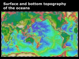
Major advances in oceanography as a consequence of geodesy: • Sea surface variability (SEASAT, etc.) • Mean dynamic sea surface (CHAMP, GRACE) • Ocean bottom pressure (GRACE,this meeting) • in future:Small scales (GOCE) 15. October 20007
challenge truncated series of spherical harmonics satellite altimeter tracks adaptive triangular grid Joint solution of geoid MSSH dyn. topog. oceanography by taking advantage of signal spectra error spectra 15. October 20007
satellite altimeter tracks truncated series of spherical harmonics adaptive triangular grid Joint solution of dyn topo. = MSSH – geoid red error spectrum MSSH = geoid + dyn topo. white? error spectrum geoid = MSSH - dyn topo. blue error spectrum 15. October 20007
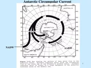
Hans Joachim Schellnhuber‘s map of ‚tipping points‘ in climate change (nature, 437, p.1238, 2005) Southern Ocean Upwelling/ Circumpolar Deep Water Formation 15. October 20007
FEOM dyn. topo. 15. October 20007
Assimilation of SSH-N: • Ensemble based Kalman Filter (SEIK) • signal error covariances > analysis cov. • Vertical extension by modes (T,S) • --> Variability • re-initialization (sources not forces) • --> eddy-mean-flow-interaction • --> eastern limb of Weddell Gyre 15. October 20007
Assimilation of SSH-N: Evolution of error (idealized experiment) free model forecast analysis 15. October 20007
geodetic dyn. topo. • SSH – GL04s1 • 37 states, 10 day frequency 2004. • smoothed with gaussian 1.35º filter • Posters: Savchenko, Albertella, Skachko 15. October 20007
offset in the mean strong circulation in the confluence area weak Weddell Gyre 15. October 20007
dyn topo temperature(100m) after assimilation too strong Antarctic Circumpolar Current too strong Weddell Gyre 15. October 20007
Conclusions • variability seems manageable • global reaction of the ocean model • local mean difference causes problems 15. October 20007
Outlook • use P-FEOM • global adjustment needed • pressure correction (forces not sources) • combine with SEIK Filter (variability) 15. October 20007
END 15. October 20007