Download
1 / 1
10 likes | 256 Views
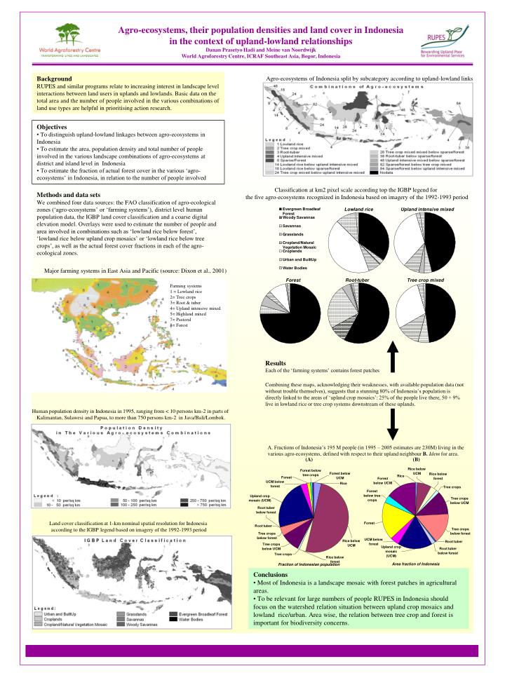
Land cover classification at 1-km nominal spatial resolution for Indonesia according to the IGBP legend based on imagery of the 1992-1993 period. Farming systems 1 = Lowland rice 2= Tree crops 3= Root & tuber 4= Upland intensive mixed 5= Highland mixed 7= Pastoral 8= Forest.

E N D
Land cover classification at 1-km nominal spatial resolution for Indonesia according to the IGBP legend based on imagery of the 1992-1993 period Farming systems 1 = Lowland rice 2= Tree crops 3= Root & tuber 4= Upland intensive mixed 5= Highland mixed 7= Pastoral 8= Forest Major farming systems in East Asia and Pacific (source: Dixon et al., 2001) Human population density in Indonesia in 1995, ranging from < 10 persons km-2 in parts of Kalimantan, Sulawesi and Papua, to more than 750 persons km-2 in Java/Bali/Lombok. Classification at km2 pixel scale according top the IGBP legend for the five agro-ecosystems recognized in Indonesia based on imagery of the 1992-1993 period Agro-ecosystems, their population densities and land cover in Indonesia in the context of upland-lowland relationships Danan Prasetyo Hadi and Meine van Noordwijk World Agroforestry Centre, ICRAF Southeast Asia, Bogor, Indonesia Agro-ecosystems of Indonesia split by subcategory according to upland-lowland links Background RUPES and similar programs relate to increasing interest in landscape level interactions between land users in uplands and lowlands. Basic data on the total area and the number of people involved in the various combinations of land use types are helpful in prioritising action research. • Objectives • To distinguish upland-lowland linkages between agro-ecosystems in Indonesia • To estimate the area, population density and total number of people involved in the various landscape combinations of agro-ecosystems at district and island level in Indonesia • To estimate the fraction of actual forest cover in the various ‘agro-ecosystems’ in Indonesia, in relation to the number of people involved Methods and data sets We combined four data sources: the FAO classification of agro-ecological zones (‘agro-ecosystems’ or ‘farming systems’), district level human population data, the IGBP land cover classification and a coarse digital elevation model. Overlays were used to estimate the number of people and area involved in combinations such as ‘lowland rice below forest’, ‘lowland rice below upland crop mosaics’ or ‘lowland rice below tree crops’, as well as the actual forest cover fractions in each of the agro-ecological zones. Results Each of the ‘farming systems’ contains forest patches Combining these maps, acknowledging their weaknesses, with available population data (not without trouble themselves), suggests that a stunning 80% of Indonesia’s population is directly linked to the areas of ‘upland crop mosaics’: 25% of the people live there, 50 + 9% live in lowland rice or tree crop systems downstream of these uplands. A. Fractions of Indonesia’s 195 M people (in 1995 – 2005 estimates are 230M) living in the various agro-ecosystems, defined with respect to their upland neighbour B.Idem for area. (A) (B) • Conclusions • Most of Indonesia is a landscape mosaic with forest patches in agricultural areas. • To be relevant for large numbers of people RUPES in Indonesia should focus on the watershed relation situation between upland crop mosaics and lowland rice/urban. Area wise, the relation between tree crop and forest is important for biodiversity concerns.