Download
1 / 34
350 likes | 400 Views
BIODIOVERSITY OF CAMEROON: THE CASE OF MBEMBE FOREST RESERVE. BY SAINGE NSANYI MOSES TROPICAL PLANT EXPLORATION GROUP ( TroPEG ), CAMEROON. BRIEF HISTORY OF TroPEG; CAMEROON. 03/G40/606/AR/BASC/SP, 8 members and based in Mundemba . Official registered in 2010.

E N D
BIODIOVERSITY OF CAMEROON: THE CASE OF MBEMBE FOREST RESERVE BY SAINGE NSANYI MOSES TROPICAL PLANT EXPLORATION GROUP (TroPEG), CAMEROON
BRIEF HISTORY OF TroPEG; CAMEROON 03/G40/606/AR/BASC/SP, 8 members and based in Mundemba. Official registered in 2010. Our vision is to become a leading partner in biodiversity of the Sub-region by providing quality and cheaper services that will enable our partners and clients to achieve their goals. Our mission is to study and document all plant species in priority areas, assist other researchers both national and international in studying other taxa, create a database of all this studies that will be available to researchers, policy and decision makers. Goal: Train young scientists in the domain of biological diversity. Serve as a platform for exchange of information with external researchers. Participate in programmes development in Biological diversity.
Concept TroPEG conducts its own research and sometimes gets funding from other services in the domain of biodiversity (forestry, botany, agriculture, GIS and environment). Forest inventories, generating of plant species list, mapping of species, and livelihood. In the agricultural sector, invasive plant species are identified and studied. Ancillary services include training in forest inventory and plant identification. Carry out consultancy during Environmental Impact Assessments (EIA), High Conservation Value assessments and generate thematic maps of study sites. Assist other researchers to study other taxa. 7 projects completed, 4 consultancy and 3 grants. 2013 – Rufford. 2012 – Rufford. 2011 – MBZ Species Conservation Fund.
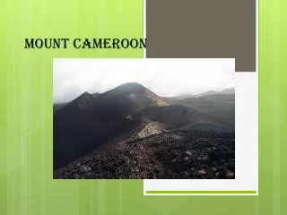
INTRODUCTION TO THIS STUDY Cameroon is one of the most diverse countries in Africa in terms of plant biodiversity hosting over 7,850 plant species (Onana, 2011). 815 species are endangered (Onanaet al. 2011). landscape that presents different vegetation types among which are the Biafra forest with high rainfall, the Congolese forest, and the semi-deciduous forest with low rain fall. Moreover, the vegetation of Cameroon ranges from lowland evergreen rainforest, semi-deciduous, deciduous, savanna woodland, and savanna grassland forest. This range from the coast to the top of Mount Cameroon (4095 m) with a long outstanding history of the Cameroon mountains or the Cameroon volcanic line that runs inland from the coast of Limbe via Mt. Cameroon, Rumpi hills, Mt. Nlonako, the Labialem highlands, Mt. Bambaoutous, Bamenda highlands to the adamawa plateau. Altitudinal gradient of lowland, sub-montane, montane and alpine forest (Letouzey, 1985; Achoundong, 2007) and form part of the Sahel regional transition zone, Guinea-Congolian/Sudanian transition zone, Sudanian, and Guinea-Congolian regional Centre of endemism (White, 1983).
Vegetation types of Cameroon Equator E Mt Cameroon (4095 m) B Cameroon A C Coastal rain forest (0 m) Fig. 1 D
Problem Statement Fig. 2 Since the creation of Mbembe Forest Reserve (MFR) in 1934 and it’s first demarcation in 1949 (Hussey, 1949), no detailed conservation and management strategy plan has been put in place by the Government of Cameroon for this reserve. This keeps us with very little or no knowledge on the biodiversity potentials of the reserve (Taku, 2004) and the livelihood of the communities. Fig. 3
Problem Statement Cont. Discussion on Mbembe Forest reserve, actually started as far back as 1926 (Pollock, 1926) as the Mbembe Native Authority forest Reserve in the Bamenda division under the United Kingdom Trusteeship. Thus, the second demarcation of the reserve was carried out in 1953 (Lightbody, 1953). It is in this light that RUFFORD Foundation via TroPEG is geared in studying the Biodiversity of Mbembe.
Objective The overall objective of this project was to assess the Biodiversity and Conservation status of plants in the Mbembe, Fungom and Kimbi forest area with emphases on the forest around Dumbu, Kwei, Gimbeu and Mayo Binka. Our effort is therefore to contribute for further awareness for decision-makers to take decision towards conservation, climate change mitigation, sustainable development and biodiversity policy for these areas.
The specific objectives were: To identify plants with high conservation, sustainable and medicinal value To produce a preliminary checklist of plants of Mbembe Forest Reserve To estimate the potential carbon stock (Above ground biomass) of the Mbembe Forest Reserve To produce a vegetation report of plants of the area, and publish new species if any.
Overview of the Mbembe Forest Reserve Area Documented records of the Mbembe landscape started as far back as 1926 as the Mbembe Native Authority Forest in the Bamenda division (Pollock, 1926). In 1934 the Mbembe forest reserve was created (204 km2), within an area of 1727.52 km2 of the Mbembe landscape (Newton, 1935). The population of this area increased to 8,434 inhabitants with a population density of 12.6 per square mile (32.8 people per km2). Fig. 4
Composed of 16 villages (The Mbembe Native Authority Area): Ako, Akoja (Akwaja), Berabe, Mbandi (Mbande), Andi (Ande), Jevi, Mbiribwa, Bogu (Buku), Ndaka, Assa, Akonko (Akwenko), Abonkwa (Abwenkpa), Abbafum, Akwonse (Akwesse), Abonse (Abuenshie) and Amba, and covers an area of 1727.52 km2 (Newton, 1935) with a population of 5,163 inhabitants. Fig. 5. Mbembe Landscape
This area was known to be the “palm oil Country” due to its vast number of natural palm trees. With steep and isolated hills, the highest village was Bebe-ketti (Bebe-kette) at1372 m, asl and the lowest is a quarter in Abonse (Abuenshie) at 259.08 m asl (Newton, 1935).
The flora is variable from open grassland through woodland savanna to semi-deciduous palm forest (Pollock, 1926, Leutousy, 1985). The valleys, slopes of hills and high ravines are forested particularly between Ako, Abonkwa and Ndaka. The plains are mostly with woodland savanna of the northern type, with vast number of palm trees which makes this area to be known as the “palm oil Country” (Newton, 1935). During one of the consultative meetings in Bogu (Buku) FonZirimbaEku and others were elected as Buku councilors.
In May 1952, a conference to discuss the future of Mbembe reserve was held at Bamenda and was attended by the Director of Agriculture (Mr. M. Park) and the Conservator of Forest (Mr. PC Randell). After the meeting, the Assistant Conservator of Forest (Mr. JBIG Ayewoh) took an extensive tour of the Mbembe Reserve, and proposed a revised boundary to exceed about 78 km2 for the benefit of the neighboring inhabitants. It was then agreed by the provincial Forest Officer in Bamenda to map and demarcate the reserve boundaries in great detail again.
It is in that regard that by March 1953, the new demarcation was increase by 282.96 km2 (93.24 km2 of high forest and 189.72 km2 of savannah) (Lightbody, 1953). However, traces of the map concerning this new demarcation cannot be seen. Thus, our bench mark regarding the boundary remains that of the 1949 which is the only well documented map of MFR. Fig. 6. Well documented Map of MFR
Geographical Position of the Study Area C A B Fig. 7.Geographical Position of the Study Area D
Methods Field surveys were done following Condit (1998) and TEAM (2010) methodology. Four hectares of (100 x 100 m each) was established at different landscapes, and vegetation type of the project area. 1-ha plot established in the forest. 1-ha in the grassland savanna. 2-ha in the woodland savannah.
Fig. 7. Four Sampled Plots Fig. 8. Four Sampled Plots
6 25 5 15 16 4 7 14 17 24 100 m 3 2 x 2 m of herb quadrat, centre of each 20 x 20 m 8 13 18 23 22 2 9 12 19 Fig. 9. 100 x 100 m 20 1 10 11 21 100 m
20 x 20 m sub-quadrat 1, 4 2, 4 3, 4 4, 4 3, 3 1, 3 2, 3 4, 3 20 m 3, 2 1, 2 2, 2 4, 2 1, 1 2, 1 3, 1 4, 1 20 m Fig. 10. 20 x 20 m
Trees and Liana Woody plants of ≥ 1 cm (10 mm) diameter at breast height (1.3 m) were measured using a diameter tape and caliper and identified by a Botanist. All liana species of the same diameter were also measured and tagged with the aid of a metal wire and aluminum nails. The xy coordinate and height of each census individual was also taken for the two woodland plots with the aid of measuring tapes and Forestry 550 laser range finder. In the forest and savanna plots, only the height and diameter were taken after tagging.
Herbs All herbs (Seedling, Sapling and real herbs) in a 2 x 2 m quadrate at the centre of each 20 x 20 m quadrate were sampled by point count. This 2 x 2 m quadrate were sub divided into 4 sub quadrates that were coded as: 1,1; 2,1; 2,2; and 1,2 to ease data collection. Plant uses (Ethnobotany) was also done intensively on the woodland and grassland plots.
Results Species Diversity and Distribution 6,679 individual plants, 7,893 stems of trees, lianas and palms recorded. 208 species in 50 families, 5 species not identified to family level. 2,508 individual stems of herbs, 190 species, and 54 families. 39 doubtful codes, 62 seedling and sapling were sorted out of the herb data Thus, 89 species of herb were recorded, 44 species identified to genus and species. 45 tree and liana species and 14 herb species were used as medicine, building materials, and food. Form Diversity Forest is more diverse in terms of tree number (4,963) and BA (2,674.91 m2)/ha compare to woodland (1577, 1683.6 m2) and savannah (301, 151.11 m2).
Tree Diversity Fig. 11. Comparing Species diversity across Vegetation types Fig. 12. Comparing Species richness across Vegetation types
Fig. 14. Woodland 2 Fig. 13. Woodland 1 IVI Fig. 15. Savannah
Herb Diversity Fig. 17. Species diversity across vegetation types Fig. 18. Species richness across vegetation types.
Table 2: Mean AGB of FR Thus. MFR has a mean range sequestration capacity of 8,095.51 ± 5386.91 SE CO2-eq., Mean AG biomass estimated at 4,411.72 ton/ha. With this results, MFR can equally be part of the climate change mitigation looking at the portion of CO2 it sequestrate as carbon sink.
Expected ResearchTarget Raise awareness on the biodiversity richness of this area Raise awareness of the need for measures to conserve/ preserve this biodiversity Influence researchers and academia to develop interest and undertake further research in this area. Provide benchmark data to development organizations to design livelihood programs, and alternatives to the forest dependent communities so that this rich biodiversity can be preserved.
TroPEG Way Forward NW Region, Cameroon Study and characterized the biodiversity of: Mbembe, Kimbi, Fungum, the transition forest between Momo, Manyu, and Libialem Divisions, and Mount Oku. Assemble all these data in to a huge data base that will enable us to calculate forest biomass, and carbon. This will give us a chance to focus better on climate change, REDD+ and Carbon trading, which at the moment is a huge data gap for Cameroon.
Acknowledgement The authors expresses their gratitude to the community members of Ako, Buku, Buku-up and Ndaka farms. Special thanks to the Administrative and traditional authorities (Divisional Officer of Ako, Fon of Buku village). Many thank to Mr. Julius NibaFon for all his Technical advice and follow-up from inception to implementation of this project. To Drs D. Kenfack and R. Condit for recommendations. Many thanks to all the Authors of this book, Mr. Minang Moses for editing the book and all TroPEG members for their great effort towards this occasion.
Acknowledgement Cont. Many thanks to Mr. Njiamsi Nelson, Mr. Tansi L. Bambo and Mme Mbah Grace for all their effort toward the success of this workshop. The Rufford Small Grants Foundation of United Kingdom provided the financial support for the field work as well as for the dissemination of the findings published in this book. We are very grateful for this financial assistance.
TroPEG June 11, 2014 Bamenda. THANKS FOR YOUR KIND ATTENTION