Download
1 / 16
190 likes | 343 Views
Landscape and Historical Climatology in Burgundy, France. Poster presented at the annual Conference of the American Society for Environmental History and the Forest History Society. March 28-April 1, 2001 in Durham, NC. De Vries, D.H. Crumley, C.L. Department of Anthropology

E N D
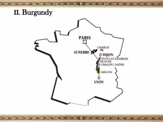
Landscape and Historical Climatology in Burgundy, France Poster presented at the annual Conference of the American Society for Environmental History and the Forest History Society. March 28-April 1, 2001 in Durham, NC. De Vries, D.H. Crumley, C.L. Department of Anthropology University of North Carolina at Chapel Hill
1. Introduction “The classical Greek word for climate, , originally referred to a zone of the Earth between two specific latitudes, being associated with the warmth and weather conditions prevailing there. This association was still embodied in the word ‘clime’ when first used to refer not only to the prevailing climate as we mean it but to the terrestrial environment, vegetation, etc., that goes with that” (Lamb, 1995, p8). The French Project at UNC-Chapel Hill has for 25 years now studied the evolution of landscape in the Department of Saône-et-Loire, region of Burgundy, France. Project researchers have used a multidisciplinary approach to study the way human activity and physical conditions jointly modify regions. Recent investigations have focused increasingly on local-scale research based in the 24-sq.-km. rural Commune (an administrative division) of Uxeau, in order to identify and document the social, political, and economic elements of land use practice together with historical and environmental circumstance that combine to sustain a productive regional economy over the long term (centuries). As part of this, a landscape level historical climatology needed to be reconstructed. This poster reports on this ongoing work arguing for a multi-scalar spatial perspective based on existing historical time-series, and presenting an ethnographic and satellite method for studying historical meso- and microclimates.
2. Global scale: A Global-Regional Working Model Gunn (Gunn & Crumley, 1991; Gunn & Folan; 2000, Gunn 1994) has proposed a global climatic working model linking atmospheric thermodynamics with regional water supply. The most important feature for global climate is the temperature of the atmosphere (solar insolation and latent heat minus radiation), which determines the boundary between polar and equatorial air masses. Atmospheric circulation is deflected by mountain ranges, pools of ocean waters, basins, seasons, and other chaotic factors. Precipitation is determined by the jet stream, which stirs the air and triggers rainfall. Regional climates are punctuated by thresholds controlled by local conditions.
3. Continental Scale: Analyzing Historic Ecotonal Shifts Based on the general global atmospheric model, the impact of climatic changes on regions can be understood by analyzing historical ecotonal shifts. Crumley (1993, 1994) has shown how the movement of the Continental, Atlantic, and Mediterranean air masses have played a role in the collapse of the economic, social, and political structure of the Roman state and contributed to what is often termed the “Dark Ages”.
4. Central European Scale: Comparing With Swiss Data Most climate historians have presented their data averaged over large zones, instead of detailing microclimatic variation. To analyze the relative correspondence of climates at this scale, temperature and precipitation data for Gueugnon (Uxeau) for the period 1949-98 were correlated with 1) Basel (1949-89) and 2) Switzerland (1949-98, Pfister, 1993). Results show that temperature correlated well with the Burgundian site with the exception of August and November for Switzerland. Precipitation correlated poorly in summer months, especially for Basel. This reflects different patterns of air masses and different topographies between the three study sites.
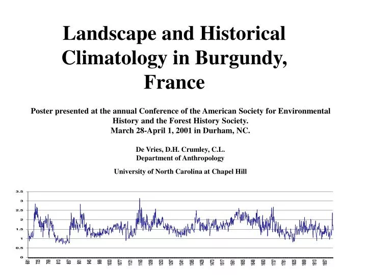
5. Regional Scale: Burgundy 29 Tree Ring Data On a regional scale, the Burgundy 29 tree ring dataset (G. Lambert C. Lavier and Y. Trenard) generalized tree cores stretching across Burgundy. The relative shifts of growth in this time series is presented below (change = (t+1)-t), with the amplitude signaling the severity of regional climatic imbalances. Correlations between temperature and rainfall (Gueugnon, 1949-89) and tree ring data for the year t and year t + 1. Autoregressive modeling showed a consistent significance of a first order effect of t-1, and May and October temperatures.
6. Regional Scale: Dijon Wine Harvest Dates Using over 103 local site that stretched Central Europe, an averaged time series of vineyard harvest dates (“Moyenne Generale”) included data on Dijon (Le Roy Ladurie, 1971). A strong shared climatic signal can be seen at this scale. Yet, harvest dates in Dijon are on average 12.2 days later than in Salins. Interregional correlations were reported to be "excellent," but the authors also almost completely ignored details on the nature of the low correlations were hidden from view and increased substantially for all periods before 1800. No mention was made about the way the Dijon local data were gathered, and nothing is known on how microclimatic differences between local vineyards in Burgundy were averaged in the Dijon series.
7. Departmental Scale: Local Hydrology Mechet Creek is located about 30 kilometers north of Gueugnon, draining from Mont Beuvray into the Aroux River. Discharge data, generally measuring precipitation, evaporation, land use, vegetation, soils, and geology in spatially bounded areas, from for the period of 1968-86 were obtained. The temperature and precipitation data for Gueugnon were correlated with these data, showing a varied correlation (significant at p>.01 only for precipitation in February and March, and February for temperature). This suggest climatic differences between the two sites.
8. Meso-/Microclimates of Uxeau: Forests “Measurements of [forest] microclimates have concentrated on mean values of selected environmental characteristics, usually a few locations and short time scales. Spatial variation is rarely assessed and the capacity to predict ecologically meaningful variation is limited.” Geoffrey Parker (1995) “Spruce trees were planted on Mount Dardou in 1960. The winter winds from the west that bring gales... they are blocked by the spruces there and stop. We have the benefit of the wind among us now, since it passes all the way to the right.” (Uxeau farmer CA) Left: The red boundary shows the 1759 extent of selected forest patches, overlayed on the 1986 SPOT satellite image showing forest in green (darker is denser). (adapted from Madry, 2001)
9. Meso-/Microclimates of Uxeau: Elevation & Geology "If a storm starts over La Chapelle, it can go in two directions: toward the foot of Dardon or toward Gueugnon; it changes course with Dardon as pivot" (Uxeau farmer GB) “Les Carraiux is protected by the Morvan, but the mountains also trap rain. And we wait... wait.. wait…” (Uxeau farmer CA) “The border of flint deposits from La Motte St. Jean to Toulon is also the ’sense of the storms' which follow the flint corridor, like a rain of flint.” (Uxeau farmer HL) “There is a strip of cherry, ash, and chestnut trees along Arroux Valley (Bessy, Tour du Bois, La Vella) beginning at about the split in the road from Bessy to Uxeau at Maison Rouge. There are no chestnuts in the valley. The flowers at Uxeau bloom before those in the valley. This is due to elevation and microclimatic change.” (Uxeau farmer HR)
10. Meso-/Microclimates of Uxeau Commune: Hydrology "In dry 1974 it rained on the left bank of the Arroux across from the Baudrions and everything was green, but not on their side" (Uxeau farmer GB) "There is a hot water spring at Les Combes, with woods in front" (Uxeau farmer BC) Left: Digital Elevation Model based on manually digitized 1:25,000 contour map shows the distances of archaeological sites in the landscape to hydrological features (from Madry, 2001)
11. Meso-/Microclimates of Uxeau: Temp., Rain, Wind “There is a microclimate between St. Radegonde (-8, -9, -10 degrees and fog) and Les Gautherons (-5 degrees and sun)” (Uxeau farmer, JM) “Regnolles (north of Veillerot) is cool at 11 am when everywhere else is hot.” (Uxeau farmer BC) “The valley of the Arroux is a cold corridor with a reputation for fog. It freezes as far south as Gueugnon. Digoin is warmer, blooming 15 days before Bessy, because the Loire captures the warmth, plus the gravel which contains the heat.” (Uxeau farmer, HR)
12 “At Dauvillaire there is no fog there when it is elsewhere. It isn't frozen when frozen, elsewhere 3-4 degree temperature difference” (Uxeau Farmer DAU) “The storms follow the path of water” (Canal du Centre, Saone) (Uxeau Farmer TB) “The small hill behind Maison Rouge (Dardou), now planted in spruce trees, gives a glacial NE wind. This was not the case when it was covered with bushes before.” (Uxeau farmer MR) “There is no microclimate at Tour du Bois, but a confirmation of a current of air between Dauvillaire and Rey homes.” (Uxeau Farmer TB) “At Les Carriaux between Dardon and Dardou, there is a special climate, a sort of a wind tunnel” (Uxeau Farmer MR) “Uxeau bourg is more windy than elsewhere and freezes less.” (Uxeau Farmer AT) “Dardon protects Maison Rouge from NW wind. It is colder in lower parts (such as Maison Rouge) but it is protected from the wind.” (Uxeau Farmer MR) “Our special climate needs hedgerows for shelter, to break the force of wind.” (Uxeau Farmer GB)
13. Meso-/Microclimates of Uxeau: An Iterative Model Left: Iterative mesoclimatic map of region of study area based on interviews with Uxeau farmers (interviews held in area in red). Microclimatic information based on individual farms is not included on this map.
References: • Crumley, Carole L. (1993) Analyzing Historic Ecotonal Shifts. Ecological Applications, 3(3), pp 377-384. • Crumley, Carole L. (1994) “The Ecology of Conquest: Contrasting Agropastoral and Agricultural Societies' Adaptation to Climatic Change.” In: Historical Ecology: Cultural Knowledge and Changing Landscapes, 183-201. Edited by C. Crumley. School of American Research Press: Santa Fe. • Gunn, Joel, D. (1994) Climate and Biocultural Diversity. In Historical Ecology: Cultural Knowledge and Changing Landscapes, 183-201. Edited by C. Crumley. School of American Research Press: Santa Fe. • Gunn, Joel D. & Carole Crumley L. (1991) Global Energy Balance and Regional Hydrology: A Burgundian Case Study. Earth Surface Processes and Landforms 16: 579-592. • Gunn, Joel D., and William J. Folan (2000) Three Rivers: Subregional Variations in Earth System Impacts in the Southwestern Maya Lowlands (Candelaria, Usumacinta, and Champoton Watersheds). In The Way the Wind Blows: Climate, History, and Human Action, edited by R. Mcintosh, J. Tainter, and S. Mcintosh, pp. 263-270, Columbia University Press, New York. • Le Roy Ladurie, E. (1971) Times of Feat, Times of Famine. Doubleday & Company, NY. • Lamb, H.H. (1995) Climate, history and the modern world. Routledge, New York. • Lambert, G. Lavier, C. and Trenard, Y. Burgundy 29 master. University of Becancon. • ftp://ftp.ngdc.noaa.gov/paleo/treering/chronologies/asciifiles/europe/fran029.crn. • Madry, S. (2001). GIS and Remote Sensing for Archaeology in Burgundy, France. • http://www.informatics.org/france/france.html. • Parker, G. (1995) "Structure and Microclimate of Forest Canopies" Academic Press. • Pfister, Christian. (1993) Historical Weather Indices from Switzerland. IGBP PAGES/World Data Center-A for Paleoclimatology Data Contribution Series # 93-027. NOAA/NGDC Paleoclimatology Program, Boulder.