Download
1 / 3
80 likes | 290 Views
Environmental Data Fusion for Mine Countermeasures (EDFMCM) – Data Assimilation. Daniel H. Wagner Associates, Inc. - www.wagner.com. The EDFMCM data mining tools provide the MCM planner/operator with the following user-friendly, operationally oriented tools:.

E N D
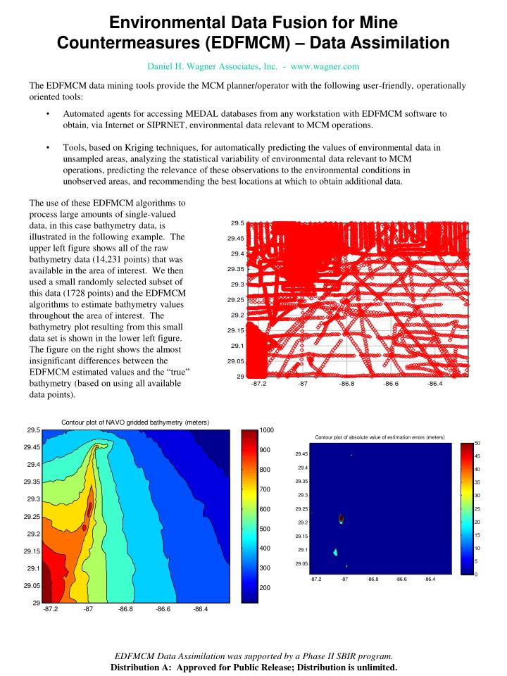
Environmental Data Fusion for Mine Countermeasures (EDFMCM) – Data Assimilation Daniel H. Wagner Associates, Inc. - www.wagner.com The EDFMCM data mining tools provide the MCM planner/operator with the following user-friendly, operationally oriented tools: • Automated agents for accessing MEDAL databases from any workstation with EDFMCM software to obtain, via Internet or SIPRNET, environmental data relevant to MCM operations. • Tools, based on Kriging techniques, for automatically predicting the values of environmental data in unsampled areas, analyzing the statistical variability of environmental data relevant to MCM operations, predicting the relevance of these observations to the environmental conditions in unobserved areas, and recommending the best locations at which to obtain additional data. The use of these EDFMCM algorithms to process large amounts of single-valued data, in this case bathymetry data, is illustrated in the following example. The upper left figure shows all of the raw bathymetry data (14,231 points) that was available in the area of interest. We then used a small randomly selected subset of this data (1728 points) and the EDFMCM algorithms to estimate bathymetry values throughout the area of interest. The bathymetry plot resulting from this small data set is shown in the lower left figure. The figure on the right shows the almost insignificant differences between the EDFMCM estimated values and the “true” bathymetry (based on using all available data points). EDFMCM Data Assimilation was supported by a Phase II SBIR program. Distribution A: Approved for Public Release; Distribution is unlimited.
Greener areas represent more effective mine-countermeasures Environmental Data Fusion for Mine Countermeasures (EDFMCM) – Intelligence Preparation of the Battlefield (IPB) Daniel H. Wagner Associates, Inc. - www.wagner.com The EDFMCM data mining tools provide the MCM planner/operator with the following user-friendly, operationally oriented tools: • Automated agents for accessing MEDAL databases from any workstation with EDFMCM software to obtain, via Internet or SIPRNET, environmental data relevant to MCM operations. • User-friendly, operationally oriented data fusion displays for accessing the data obtained by EDFMCM agents. These automated data fusion algorithms merge spatially varying data from multiple sources, with information concerning the values of multiple attributes, and associated with areas of arbitrary shape, into a set of polygons that cover an area of interest and have the correct attribute values. The data fusion displays will allow the MCM planner/operator, with a minimal amount of effort, to visualize the effects of the relevant environmental parameters on both the threat posed by various types of mines and the ability of MCM forces to neutralize the threat from these mines. This process is illustrated in the figure above, which shows the MCM IPB process that has been implemented in the Navy’s GCCS-M Segment for Mine Warfare, the Mine Warfare Environmental and Tactical Decision Aids Library (MEDAL), through the use of EDFMCM algorithms. This IPB process breaks up the area of interest into areas of essentially similar MCM performance, known as Tactically Significant Regions (TSRs), taking into account all pertinent environmental and system parameters. These TSRs can then be used to display system effectiveness along a track or area of interest, as shown below. In addition, these TSRs are used to calculate the effectiveness of planned and actual search tracks much more accurately than was previously possible, and they are also utilized when calculating the risk to transiting or patrolling ships from undetected mines. EDFMCM IPB was supported by a Phase II SBIR program. Distribution A: Approved for Public Release; Distribution is unlimited.
Current, Wind, and Wave Data Fusion (CWWDF) System Daniel H. Wagner Associates, Inc. - www.wagner.com Wagner’s Current, Wind, and Wave Data Fusion (CWWDF) System is a state-of-the-art system that uses advanced mathematical and probabilistic methods to improve critical estimates of environmental conditions and the corresponding impact of these on mission planning and execution. Measurements of environmental data occur at discrete points spread out in both time and space. Current environmental systems either use the nearest data point or do simple interpolation when generating estimates of current, wind, and wave conditions. Furthermore, none of the systems in use today contain algorithms for determining the effectiveness of divers when conducting MCM operations as a function of current, wind, waves and other environmental factors, for determining the effectiveness of influence sweeping when conducting MCM operations as a function of wave conditions, or for determining the placement of cleared lanes for use by landing craft. The key advantage of the CWWDF environmental data fusion algorithms is their use of Kriging techniques when determining what values should be used at positions/times for which modeled data or measured data is not directly available. Kriging is a method of spatial-temporal interpolation named after a South African mining engineer named D.G. Krige, who developed the technique in an attempt to more accurately predict ore reserves. Kriging is based on the assumption that the parameter being interpolated varies in a continuous manner from one location to the next and therefore points that are near each other have a certain degree of spatial correlation, but widely separated points are statistically independent. The contour plot above shows the prediction errors at a specific point in time for the CWWDF system applied to a wind vector field supplied via COAMPS. The circles represent COAMPS supplied sample points. The Mean Absolute Prediction Error is 0.33 m/s, while the overall RMS Prediction error is 0.47 m/s. Significant improvements in operational performance also derive from the algorithms in CWWDF that: • Determine the effectiveness of divers when conducting MCM operations as a function of current, wind, waves and other environmental factors, • Determine the effectiveness of influence sweeping when conducting MCM operations as a function of wave conditions, and • Determine the placement of cleared lanes for use by landing craft. The non-Gaussian algorithms in CWWDF for determining the position of drifting mines or personnel are much more accurate than those currently used by the U.S. Navy and Coast Guard. This translates directly into a smaller location uncertainty – for the Navy this means reduced assets or time for the same operation – for the Coast Guard this means more lives can be saved. These algorithms can also be used to estimate the source of drifting mines, providing an important tool for countering the use of suchmines by terrorists. CWWDF is currently supported by a Phase II SBIR program. Distribution A: Approved for Public Release; Distribution is unlimited.