Download
1 / 32
340 likes | 609 Views
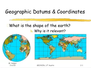
Grids and Geographic Coordinates. Grids and grid coordinates. The geographic grid system was created to locate all places on Earth. It uses latitude and longitude to describe the location of any place on Earth. Grids and grid coordinates.

E N D
Grids and grid coordinates • The geographic grid systemwas created to locate allplaces on Earth. • It uses latitude andlongitude to describe the location of any place on Earth.
Grids and grid coordinates • One way of mappingthe world is on a globe,because Earth is a sphere,which is a 3D shape. • A map is usually a 2D drawing, and shows an accurate image of a place. • Most people find 2D mapseasier to use than globes.
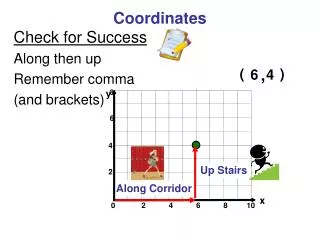
Grids and grid coordinates • Grids and geographic coordinates are used to locate places on a map. Grids are evenly spaced horizontal and vertical lines placed on a map. Letters or numbers are placed along the sides of a grid. They are combined to give grid coordinates for any location.
Grids and grid coordinates • Why is it useful to be able to quickly locate places on a map? When have you had to locate places on a map?
Grids and grid coordinates • Maps in atlases and street directories are common examples of where you might use grid coordinates.
Grids and grid coordinates • On this map, the grid coordinates are alphanumeric. Alphanumeric means a combination of letters and numbers.
Grids and grid coordinates • On this map, the grid coordinates are alphanumeric. What common type of map generally uses alphanumeric coordinates?
Grids and grid coordinates • Locate the sports oval at Blair College. The grid coordinate is C3. The oval is easily located within the square bounded by the grid coordinates.
Grids and grid coordinates • Note that the coordinate for the horizontal grid lines is given first, and the vertical grid coordinate second.
Eastings, northings and area references • The numbers that refer to the vertical grid lines are called eastings.
Eastings, northings and area references • They increase in value as you move across in an easterly direction.
Eastings, northings and area references • The numbers that refer to the horizontal grid lines are called northings. They increase in value as you move up in a northerly direction.
Eastings, northings and area references • The two eastings numbers are joined with the two northings numbers to make a four-figure area reference.
Eastings, northings and area references • For example, a % symbol is located at eastings 46 and northings 22, so its area reference is 4622.
Grid references • Grid references locate places on a map more accurately than area references. A grid reference is a six figure number, made up of a three-figure eastings reading and a three-figure northings reading. A grid reference is found by mentally subdividing each grid square into tenths. The third figure in each eastings and northings reading is found by estimating how many tenths across or up the exact location is.
Grid references • What is the grid reference for the Post Office? Answer – 283579
Grid references • Name the feature at 280570. Answer – An island
Grid references • Name the feature at 258576. Answer – The river mouth
Grid references • Find the Grid Reference for numbers 1- 4 4 1 2 3
Grid coordinates – latitude and longitude • To locate different places around Earth, we use geographic coordinates – measurements of latitude and longitude. Lines of latitude are imaginary parallel lines that circle the globe in an east–west direction.
Grid coordinates – latitude and longitude • The Equator divides Earth into northern and southern hemispheres. Latitude measures how many degrees north or south a point on Earth lies from the Equator.
Grid coordinates – latitude and longitude • What is the name given to the imaginary line of latitude at: • 23.5O south of the Equator? Tropic of Capricorn
Grid coordinates – latitude and longitude • What is the name given to the imaginary line of latitude at: • 23.5O north of the Equator? Tropic of Cancer
Grid coordinates – latitude and longitude • What is the name given to the imaginary line of latitude at: • 66.5O south of the Equator? Antarctic Circle
Grid coordinates – latitude and longitude • What is the name given to the imaginary line of latitude at: • 66.5O north of the Equator? Arctic Circle
Grid coordinates – latitude and longitude • Lines or meridians of longitude are imaginary lines between the North and South Poles.
Grid coordinates – latitude and longitude • Longitude measures how many degrees east or west a point on Earth is from the Prime Meridian.
Grid coordinates – latitude and longitude • The Prime Meridian is the meridian of longitude at 0O. It divides Earth into eastern and western hemispheres.
Grid coordinates – latitude and longitude • What is the name given to the imaginary line at 180O from the Prime Meridian? International Date Line
Grid coordinates – latitude and longitude • Find out why it is given this name.Suggest why it is this shape. International Date Line
Grid coordinates – latitude and longitude • The exact location of any place on Earth is given by its geographic coordinates. • You can find examples in the index of your atlas. Measurements for latitude and longitude are given in degrees (and minutes). Latitude is stated first, then longitude. Sydney’s geographic coordinates are: 33.52S 151.10E