Download
1 / 1
10 likes | 116 Views
The Spatial and Temporal Variability of Nonfreezing Drizzle in the United States and Canada. P2.46. Addison L. Sears-Collins , Oklahoma Weather Center Research Experiences for Undergraduates, and Pennsylvania State University, State College, Pennsylvania

E N D
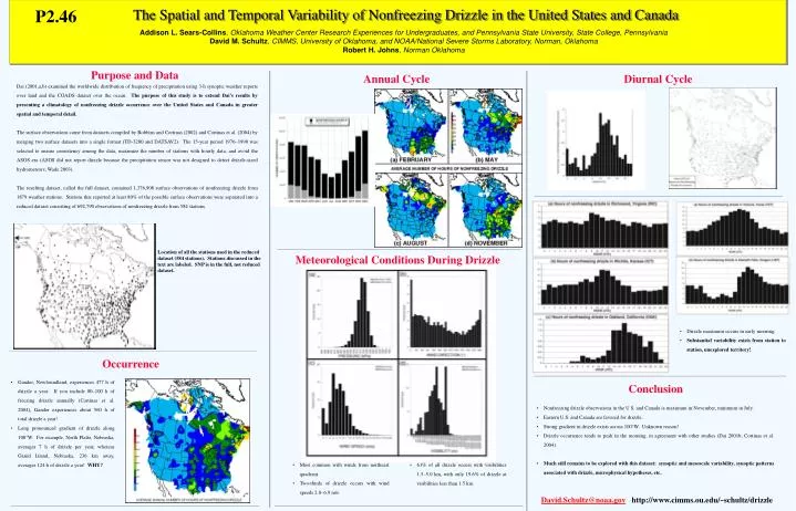
The Spatial and Temporal Variability of Nonfreezing Drizzle in the United States and Canada P2.46 Addison L. Sears-Collins, Oklahoma Weather Center Research Experiences for Undergraduates, and Pennsylvania State University, State College, Pennsylvania David M. Schultz, CIMMS, University of Oklahoma, and NOAA/National Severe Storms Laboratory, Norman, Oklahoma Robert H. Johns, Norman Oklahoma Purpose and Data Annual Cycle Diurnal Cycle Dai (2001,a,b) examined the worldwide distribution of frequency of precipitation using 3-h synoptic weather reports over land and the COADS dataset over the ocean. The purpose of this study is to extend Dai’s results by presenting a climatology of nonfreezing drizzle occurrence over the United States and Canada in greater spatial and temporal detail. The surface observations come from datasets compiled by Robbins and Cortinas (2002) and Cortinas et al. (2004) by merging two surface datasets into a single format (TD-3280 and DATSAV2). The 15-year period 1976–1990 was selected to ensure consistency among the data, maximize the number of stations with hourly data, and avoid the ASOS era (ASOS did not report dirzzle because the precipitation sensor was not designed to detect drizzle-sized hydrometeors; Wade 2003). The resulting dataset, called the full dataset, contained 1,376,908 surface observations of nonfreezing drizzle from 1879 weather stations. Stations that reported at least 80% of the possible surface observations were separated into a reduced dataset consisting of 692,790 observations of nonfreezing drizzle from 584 stations. Location of all the stations used in the reduced dataset (584 stations). Stations discussed in the text are labeled. SNP is in the full, not reduced dataset. Meteorological Conditions During Drizzle • Drizzle maximum occurs in early morning. • Substantial variability exists from station to station, unexplored territory! Occurrence • Gander, Newfoundland, experiences 477 h of drizzle a year. If you include 80–100 h of freezing drizzle annually (Cortinas et al. 2004), Gander experiences about 560 h of total drizzle a year! • • Long pronounced gradient of drizzle along 100°W. For example, North Platte, Nebraska, averages 7 h of drizzle per year, whereas Grand Island, Nebraska, 236 km away, averages 124 h of drizzle a year! WHY? Conclusion • Nonfreezing drizzle observations in the U.S. and Canada is maximum in November, minimum in July. • Eastern U.S. and Canada are favored for drizzle. • Strong gradient in drizzle exists across 100°W. Unknown reason! • Drizzle occurrence tends to peak in the morning, in agreement with other studies (Dai 2001b; Cortinas et al. 2004). • Much still remains to be explored with this dataset: synoptic and mesoscale variability, synoptic patterns associated with drizzle, microphysical hypotheses, etc. • Most common with winds from northeast quadrant. • Two-thirds of drizzle occurs with wind speeds 2.0–6.9 m/s. • 61% of all drizzle occurs with visibilities 1.5–5.0 km, with only 19.6% of drizzle at visibilities less than 1.5 km. David.Schultz@noaa.gov http://www.cimms.ou.edu/~schultz/drizzle