Download
1 / 9
90 likes | 168 Views
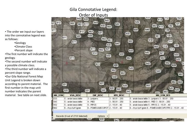
Gila Connotative Legend: Order of Inputs. The order we input our layers into the connotative legend was as follows: Geology Climate Class Percent slope The first number will indicate the geology. The second number will indicate a possible climate class.

E N D
Gila Connotative Legend:Order of Inputs • The order we input our layers into the connotative legend was as follows: • Geology • Climate Class • Percent slope • The first number will indicate the geology. • The second number will indicate a possible climate class. • The third number will indicate a percent slope range. • Our Gila National Forest Map Unit Legend is broken down according to parent material. The first number in the map unit number indicates the parent material. See table on next slide.
Gila Connotative Legend:Geology Input • Geology layers input: • Geologic Map of New Mexico, New Mexico Bureau of Geology and Mineral Resources, 2003, Scale 1:500,000. • Ratté, J.C., 2001, Geologic Map of Tularosa Mountains, 30’ x 60’ Quadrangle, Catron County, New Mexico: U.S. Geological Survey Miscellaneous Geologic Investigations Series I-2619, Scale 1:100,000 • Currently there are no digital geology layers that at the 1:24,000 scale. The available geology layers are merged into one continuous raster coverage and reclassified.
Gila Connotative Legend:Geology Input • Geology layer classification: • 9 – Null (no value) • 0 – Alluvium • 1 – Volcanic Sediment/Conglomerate, Mixed Conglomerate • 2 - Limestone/Mixed, Other Sedimentary • 3 – Granite, Gneiss • 5 – Andesite, Basaltic Andesite, Basalt, Latite • 6 – Rhyolite, Tuff, Ignimbrite • Some of the units in both the original Ratte (2001) and the original Geologic Map of NM (2003) are mixed units. A unit may be mostly andesitic basalt, but may also have volcanic tuff and ignimbrite associated with it. These were originally assigned a dominant class. • Revision will include a class of mostly “mixed” units. These will be assigned an “8”. This should help identify areas that need special attention and more ground verification.
Gila National ForestStatistics using Geology Layer • The resulting geology layer is very general and is mainly used for premapping, or for quickly checking for “outlier” polygons when running statistics. Most of the polygons that get flagged during statistics are due to differences in scale of mapping and are ignored, especially in alluvial areas. In the example to the right, you can see where the geology map called some areas basalt (green), where at 1:24,000 scale it is really alluvial or conglomerate. The majority of the selected polygon to the right was rhyolite, so it was flagged in the statistics. I can now double check that area and see if I want to change anything.
Gila Connotative Legend:Generalized Climate Class • The Existing Vegetation Classification for the southwestern region was used and reclassified according to the climate class of the dominant species • The current classes include: • 9 – Null (Water, No data) • 1 – Undifferentiated climate class; Grassland • 3 – Undifferentiated climate class; Juniper dominated • 4 – Pinon Pine dominated • 5 – Ponderosa Pine dominated • 6 – Doug -fir, White Fir, or Aspen dominated • 7 – Corkbark Fir dominated • This is a general map of existing vegetation classes, and does not reflect potential vegetation. It is simply a proxy to get a general idea of the climate class during premapping. We have not used this layer when running statistics. I only use the aspect and elevation layers when running statistics to find any major outliers in the climate class.
Gila Connotative Legend:Generalized Climate Class • The column 1 and column 3 do not correspond to a particular climate class. These are place markers for areas dominated by grass or juniper, respectively, and can be in any climate class. • The current classification needs to be revised. There needs to be another mixed or undifferentiated class for areas dominated by “shade intolerant” and “shade tolerant evergreen” trees. These will be given an “8” and will not have a climate class associated with them. Areas dominated by Quercus sp. or by Aspen will be classified as an “2”. There will be no climate class associated with these units. The later could indicate edaphic-fire areas.
Gila Connotative Legend:Percent Slope • Continuous 10 meter percent slope was reclassified in the connotative legend into the following categories: • 9 – No value • 1 – 0-15 percent slope • 2 – 15.01-40 percent slope • 3 – 40.01-250 percent slope
Gila Connotative Legend:Connotative Legend to Map Unit Legend Crosswalk • A query was created in Access that allows us to crosswalk the connotative map unit number to a current map unit component being used on the Gila National Forest. • Example - Connotative Legend Map Unit # 562 • “5” - Basalt, Andesite, Latite. Query brings up all Gila components in the 500’s. • “6” - Column 6. Query narrows down all 500 components that are in column 6. • “2” – 15-40% slopes. Query then selects those components with 15-40% slopes. • You now have a list of existing map unit components that share the same geology, climate class and slope class as the polygon developed from the connotative legend. You can then narrow down your options when you field check the area. • The query brings up all climate steps within a climate class. In the example to the right, 533 0.5 is a HSC 6,0; where 562 0.1 is a HSC 6,-1. If you know the area is a HSC 6-1, you can ignore all other 6,0 or 6,+1 components.