Download
1 / 11
110 likes | 213 Views
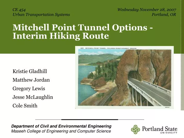
CE 454 Urban Transportation Systems. Wednesday November 28, 2007 Portland, OR. Mitchell Point Tunnel Options -Interim Hiking Route. Kristie Gladhill Matthew Jordan Gregory Lewis Jesse McLaughlin Cole Smith.

E N D
CE 454Urban Transportation Systems Wednesday November 28, 2007Portland, OR Mitchell Point Tunnel Options -Interim Hiking Route Kristie Gladhill Matthew Jordan Gregory Lewis Jesse McLaughlin Cole Smith Department of Civil and Environmental EngineeringMaseeh College of Engineering and Computer Science
Construction on the Columbia River Highway began in 1913 Intended to connect Oregon from The Dalles to Astoria The road was not merely functional Designed by Samuel C. Lancaster Meant to showcase Oregon’s beauty The Columbia River Highway
The Mitchell Point Tunnel • Designed by John Arthur Elliott • Patterned after the Axenstrasse in Switzerland • Completed in 1915 • Restricted to one-way traffic 1937 • Destroyed in 1966
ORS 377.100 designates remnants of the Columbia River Highway as historic. ORS 366.550 outlines plans to reconnect and restore the highway. Part of this plan is the recreation of the Mitchell Point Tunnel Highway Restoration P p
Until the tunnel is completed a hiking trail is planned. ODOT and The Friends of the Historic Columbia River Highway (FHCRH) are overseeing the project. Our group participated in a workshop that collaborated design options with FHCRH. Interim Trail
Planning the Trail Step 1 – Decide the trail’s purpose (eventually part of recreational loop) Step 2 – Inventory the property • What land does it lie on? • What is the available access?
Planning the Trail • Step 3 – Design the Trail • Reference pertinent trail regulations. • Propose a trail route using topographic information. • Step 4 – Scout the Trail • Conduct a site visit and walk the proposed route.
Trail Problems Grade • Average Grade of 8.4%. 2 areas at 15 and 16% over 150 ft. spans. Soil • Trail section covered with large loose rocks. Width • Trees & cliffs create narrow pathways Clearance • Low Branches
Proposed Route Our group proposes the following route Maximum Elevation – 469 ft Maximum Slope - 16º Distance – 0.53 miles
Conclusion What would Samuel Lancaster do? • Does the trail fit the vision? • Can it be made? • What needs to happen next?
Sources Andrew, Andrews. “Mitchell Point Tunnel, Columbia River Tunnel, ca. 1920.” Postcard. 1 January 2007. Accessed 3 October 2007. <http://www.iinet.com/~englishriver/LewisClarkColumbiaRiver/Regions/Places/mitchell_point.html>. Brooks, Pete. “Cliff Stabilization.” Graphic. Historic American Engineering Recording Project, National Park Service. 1995. “Columbia River Highway.” en.wikipedia.org. 3 October 2007. Accessed 6 October 2007. <http://en.wikipedia.org/wiki/columbia_river_highway>. Dun, Michael. “Crown Point.” Photo. 17 October 2007. Accessed 17 October 2007. <http://www.vancouver.wsu.edu/fac/dunnmi/vista.jpg>. “Friends of the Historic Columbia River Highway.” Friends of the Historic Columbia River Highway Accessed 6 October 2007. <http://hcrh.org/about.html>. “The Historic Columbia River Highway.” egov.oregon.gov. Accessed 6 October 2007. <http://egov.oregon.gov/ODOT/HWY/HCRH/minutes.shtml>. “Mitchell Point Tunnel.” en.wikipedia.org. 16 July 2007. Accessed 6 October 2007. <http://en.wikipedia.org/wiki/Mitchell_Point_Tunnel>. “Mitchell Point Tunnel.” The Columbia River, “A Photographic Journey.” January 2007. Accessed 6 October 2007. <http://www.iinet.com/~englishriver/LewisClarkColumbiaRiver/Regions/Places/mitchell_point.html>. Oregon Department of Transportation. “Sam Hill.” Photo. The Historic Columbia River Highway Pamphlet. No Publish Date. The Oregon News Corps. "Interior Mitchell Point Tunnel, Columbia River Highway, Oregon." Postcard. 1 January 2007. Accessed 3 October 2007. <http://www.iinet.com/~englishriver/LewisClarkColumbiaRiver/Regions/Places/mitchell_point.html>. Pierce, Elaine, Simonenko V.V. “Historic Columbia River Highway Shield.” Graphic. Historic American Engineering Recording Project, National Park Service. 1995. “Recreational Trail Design”. University of Minnesota Extension. 2007. Accessed 15 November 2007. <http://www.extension.umn.edu/distribution/naturalresources/DD6371.html#trail1>.