Download
1 / 20
210 likes | 482 Views
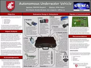
Autonomous Surface Vehicle. MyAsia Reid 1 , Linda Kpormone Buame 2 , Amadi Sefah-Twerefour 2 , Prosper Yaw Adiku 2 , George Owusu Fordah 2 , Center for Remote Sensing of Ice Sheets (CReSIS), University of Kansas, Lawrence, KS 66045

E N D
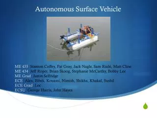
Autonomous Surface Vehicle MyAsia Reid1, Linda Kpormone Buame2, Amadi Sefah-Twerefour2, Prosper Yaw Adiku2, George Owusu Fordah2,Center for Remote Sensing of Ice Sheets (CReSIS), University of Kansas, Lawrence, KS 66045 1Elizabeth City State University, Elizabeth City, N C 27909 2Department of Oceanography & Fisheries, University of Ghana, Legon Mentors: Dr. Eric Akers, Ben Panzer, Kyle Byers and Jerome Mitchell
OUTLINE • Introduction • Methodology • Results • Conclusion • References
Introduction The response of organisms to changes in water quality parameters enhances our understanding of aquatic environment (Abowei, 2009). MODIS) and SeaWIFs, are limited by assumption of uniformity in pixels (Yuan et al, 2005). Designs limited to open oceans Insufficient sampling, Inaccuracy of geophysical corrections. Sampling can be augmented by using more than one mission (Bouffard et al, 2008) http://www.alticore.eu/ Dunbabin et al, 2009
Design considerations • Drag depends on size, shape & speed: force due to drag • (F)= 0.5rhoV²CdA, lowest Cd is the best • F is proportional to speed, >speed needs more thrust and a greater drain on power. Weight Drag Thrust Buoyant force and Lift
Methodology Design components • Microcontroller (Atmega 328) • Motor controllers (10A brushed) • Breadboard • SD Card Reader • GPS -shield (09487) -module (EM 406) • Temperature Sensors (LM335a) • Batteries(12V/8Ah , 12V/18Ah)
Primary Navigation systems GPS and Gyro M2 Motor controllers uMMC data storage Module Microcontroller M1 Sensor payload Temperature sensor Design ASV flowchart….
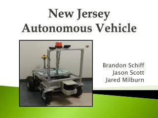
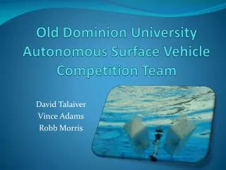
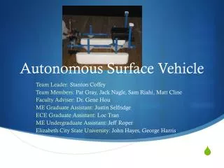
Final design of ASV In the workshop On land
Arduino • What is an Arduino? • is a single-board microcontroller and a software suite for programming it. The software consists of a standard programming language and the boot loader that runs on the board. • Microcontroller: The hardware consists of a simple open hardware design for the controller with an Atmel AVR processor and on-board I/O support.
Temperature sensor • Analog temperature sensor • Works like a Zener diode • Calibrated at 25°C at and 5V input voltage and a 2.982V output LM335A
Navigation and Control (GPS) • GPS & Bearing…. • Satellite based navigation system. • Based on the network of 24 satellites. • GPS intended for military use, but available for civilian use in the 1980’s. • Works off satellite, tracking positions of locations. • For direction, tracking and navigation. www.diytrade.com www.vialite.co.uk www.rei.com www.navigadget.com
GPS-09487 GPS Shield Connector Vertical SMD for EM408 Coin Cell Holder - 12mm 20 Channel EM-406A SiRF III Receiver with Antenna EM 406 Credit: http://www.sparkfun.com/
Bearing calculations.. • Bearing calculations done in radians Bearing (x) =atan2(sin(lon2-lon1)*cos(lat2),cos(lat1)*sin(lat2))sin(lat1)*cos(lat2)*cos(lon2-lon1));- degrees=x* 180/M_PI; (M_PI is the constant from math.h set for value of PI) To ensure that it remains in proper range Degrees=degrees + 360°; if degrees is less than 0 http://drifters.doe.gov/track-a-yoto/track-a-drifter.html
Distance calculations • Haversine distance calculations dlat= lat2-lat1 dlon=lon2-lon1 a=pow(sin(dlat/2),2)+cos(lat1)*pow(sin(dlon/2),2); c=2*atan2(sqrt(a),sqrt(1-a)); Distance= r*c;// radius of the earth in meters r = 6378140m Credit: http://en.wikipedia.org/wiki/Haversine_formula
Conclusion • An ASV that can navigate specific way point has been built. • Future work would focus on increasing sensor capacity by putting on board more sensors as well as buoy mode and possibly obstacle avoidance.
Acknowledgements Thanks to: • Dr. Eric Akers • Dr. Claude Laird • Dennis Sundermeyer • Leon Searl • Ben Panzer • Kyle Byers • Jerome Mitchell
References Abowei, J.F.N (2010) Salinity, Dissolved Oxygen, pH and Surface Water Temperature Conditions in Nkoro River, Niger Delta, Nigeria, Advance Journal of Food Science and Technology 2(1): 36-40, 2010 Dunbabin, M., Alistair G. and J. Udy (2009) An Autonomous Surface Vehicle for Water Quality Monitoring Autonomous Systems Laboratory, CSIRO ICT Centre, P.O. Box 883, Kenmore, QLD 4069, Australia. Get a bearing. Accessed from the world wide web on 14th June,2010 at http://geaology.isu.edu/geostac/Fieldexercie/topomaps/bearing.html Great circle.Accessed from the world wide web on 18th July 2010 at www.answers.com/topic/great_circle Haversine formula. Accessed from the world wide web on 8th July,2010 at www.absoluteastronomy.com/topics/Haversine_formula Haversine formula.Accessed from the world wide web on 14th June 2010 at http://en.wikipedia.org/wiki/Haversine_formula J. Bouffard,1 S. Vignudelli,2 P. Cipollini,3 and Y. Menard (2008) Exploiting the potential of an improved multimissionaltimetric data set over the coastal ocean. Geophysical research letters, vol. 35, l10601, 2008 Latitude and Longitude general information. Accessed from the world wide web on 11th June 2010 at www.csgnetwork.com/latloninfo.html Mathematics<math.h>.Accessed from the world wide web on 25th June,2010 at http://www.nongnu.org/avr-libc/user-manual/group_avr_math.html Rogue robotic [online] www.roguerobotics.com What is latitude and longitude. Accessed from the world wide web on 18th July 2010 at www.rain.org/camp.internet/gis_latlong What is programming? Accessed from the world wide web on 18th July 2010 at http://mysite.du.edu/~jcalert/math/program.html Yuan, J., Dagg, M. J., Del Castillo C. E (2005) In-pixel variations of chl a fluorescence in the Northern Gulf of Mexico and their implications for calibrating remotely sensed chl a and other products. Department of Marine Science, University of Southern Mississippi, USA